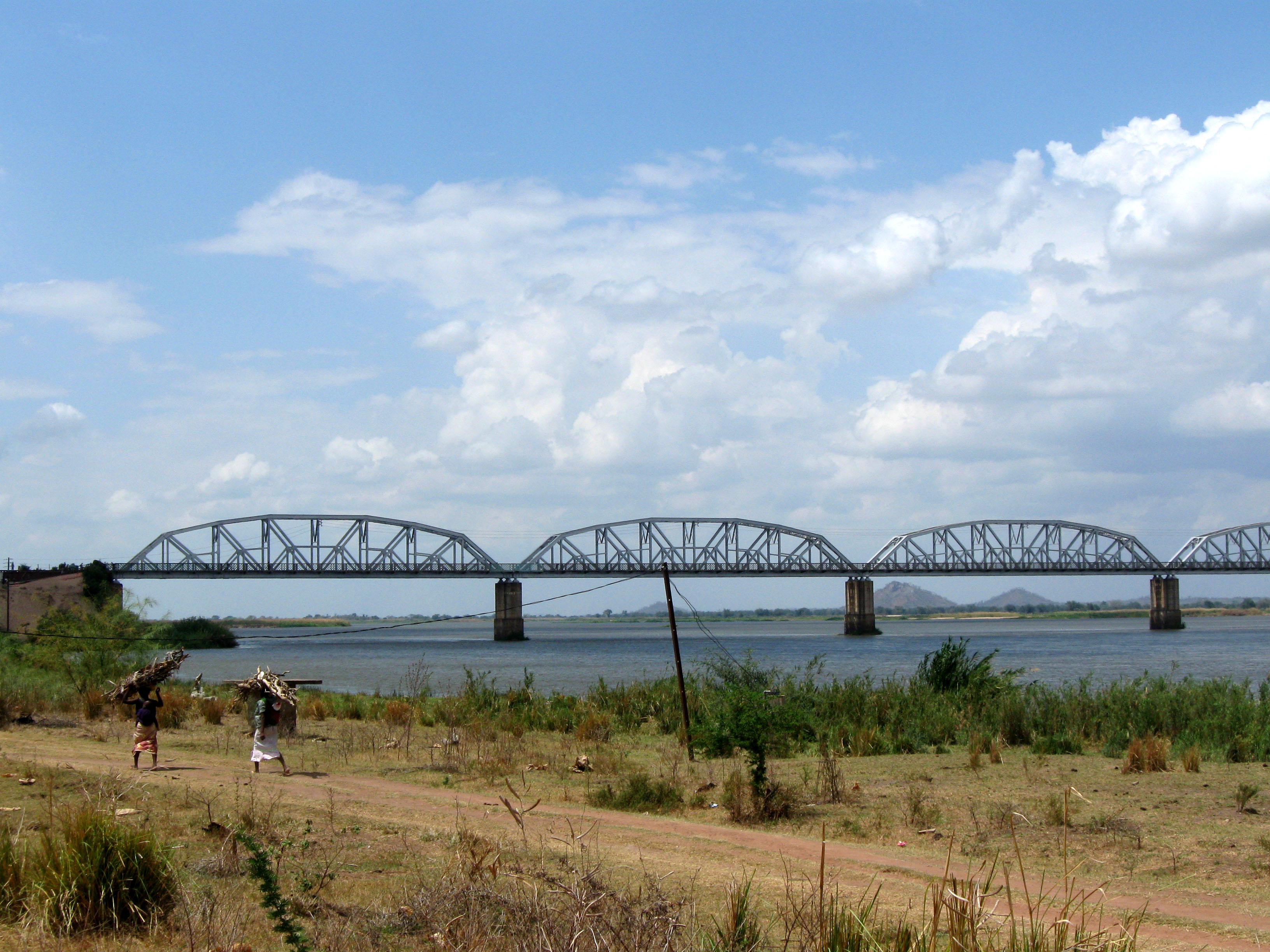
Dona Ana Bridge
Three thousand people cross it on foot every day. The Dona Ana Bridge, 3.67 kilometers of steel and concrete spanning the lower Zambezi River, was never designed for pedestrians. It was built as a railway bridge in 1934, converted to a single-lane road bridge after civil war wrecked it, then reconverted to rail again in 2009. Through every transformation, people kept walking across it -- because when you need to cross the Zambezi in central Mozambique, you take whatever bridge exists.
The Missing Link
The story begins with a gap in a railway line. By 1914, the British South Africa Company had completed the Central African Railway from Nsanje in Nyasaland (now Malawi) to Chindio on the north bank of the Zambezi. From the south bank, another railway ran to the port of Beira. Between them: the river, and a ferry that was maddeningly unreliable. During the dry season, the water ran too shallow. During the wet season, floods washed sections of track away. Moving goods from Blantyre to Beira took two to three weeks, involved three transhipments, and exposed cargo to constant water damage. In 1922, the Trans-Zambezia Railway Company closed most of the gap by extending rail to Murracca, opposite Chindio, but the ferry crossing remained the weak link. In 1927, the British government commissioned a study to solve the problem permanently.
An Empire's Span
The Hammond Report recommended a bridge at Mutarara, 25 miles upriver of Chindio, where the river was narrower but the crossing still formidable. The estimated cost was 1.06 million pounds. The final bill came to 1.74 million -- and the bridge never generated enough traffic to pay even the interest on the loans raised to build it. None of that diminished the engineering achievement. Completed in 1934 under Portuguese colonial rule, the Dona Ana Bridge comprised 33 spans of 80 meters and 7 spans of 50 meters, stretching 3.67 kilometers between Vila de Sena on the south bank and Mutarara on the north. It was the longest railway bridge in Africa at the time, and it remains the longest bridge of any kind across the entire Zambezi River. The bridge did not just link two towns; it linked Malawi and the Moatize coal fields to the Indian Ocean port of Beira, effectively stitching together the two halves of Mozambique.
War, Ruin, and Reinvention
The Mozambican Civil War, which raged from 1977 to 1992, rendered the bridge unusable. By the time the fighting stopped, the Dona Ana Bridge was a wreck -- its rail infrastructure destroyed, its approaches damaged. USAID assisted with repairs, but rather than rebuild it as a railway, engineers converted it to a single-lane road bridge. The decision was practical: Mozambique desperately needed road crossings of the Zambezi, and the only alternatives were the bridge at Tete, far upstream, and a road ferry at Caia that frequently broke down. For years, the Dona Ana Bridge served as an unlikely highway, carrying vehicles single-file across a structure that Portuguese railway engineers had never imagined would bear truck traffic.
Back on the Rails
In October 2006, the bridge was closed to vehicles for rehabilitation and reconversion to its original purpose. The Armando Emilio Guebuza Bridge, completed downstream in 2009, finally gave Mozambique a proper road crossing at Caia, freeing the Dona Ana to return to rail service. It reopened as a railway bridge in 2009, restoring the link between the Moatize coal fields and the port of Beira that had been its reason for existing since the 1930s. In 2017, the bridge underwent further renovation, with particular attention to its pedestrian lane. That lane had never been a formal design feature, but three thousand people used it daily regardless -- walking between communities separated by one of Africa's great rivers, on a bridge built by one empire, wrecked by civil war, patched by foreign aid, and still standing after nearly a century.
From the Air
Located at 17.44S, 35.05E, spanning the lower Zambezi River between Vila de Sena and Mutarara in central Mozambique. The bridge is a striking linear feature from altitude -- 3.67 kilometers of steel truss spans crossing the broad, braided Zambezi floodplain. It is the longest bridge across the Zambezi River. The nearest significant airfield is at Beira (FQBR), approximately 200 km to the southeast. The Zambezi itself is a major visual navigation landmark, flowing generally east toward the Indian Ocean.