Double Bluff Beach
Mammoth teeth wash out of the bluffs here. Not metaphorically. The 300-foot cliffs at Double Bluff Beach on southern Whidbey Island are eroding their way through 200,000 years of geological history, and occasionally that history includes the remains of animals that roamed the Puget Sound lowlands during the ice ages. The beach itself stretches roughly two miles along the shore of Admiralty Inlet, a sweep of sand, driftwood, peat slabs, and glacial erratic boulders that feels more like a natural museum than a day-use park.
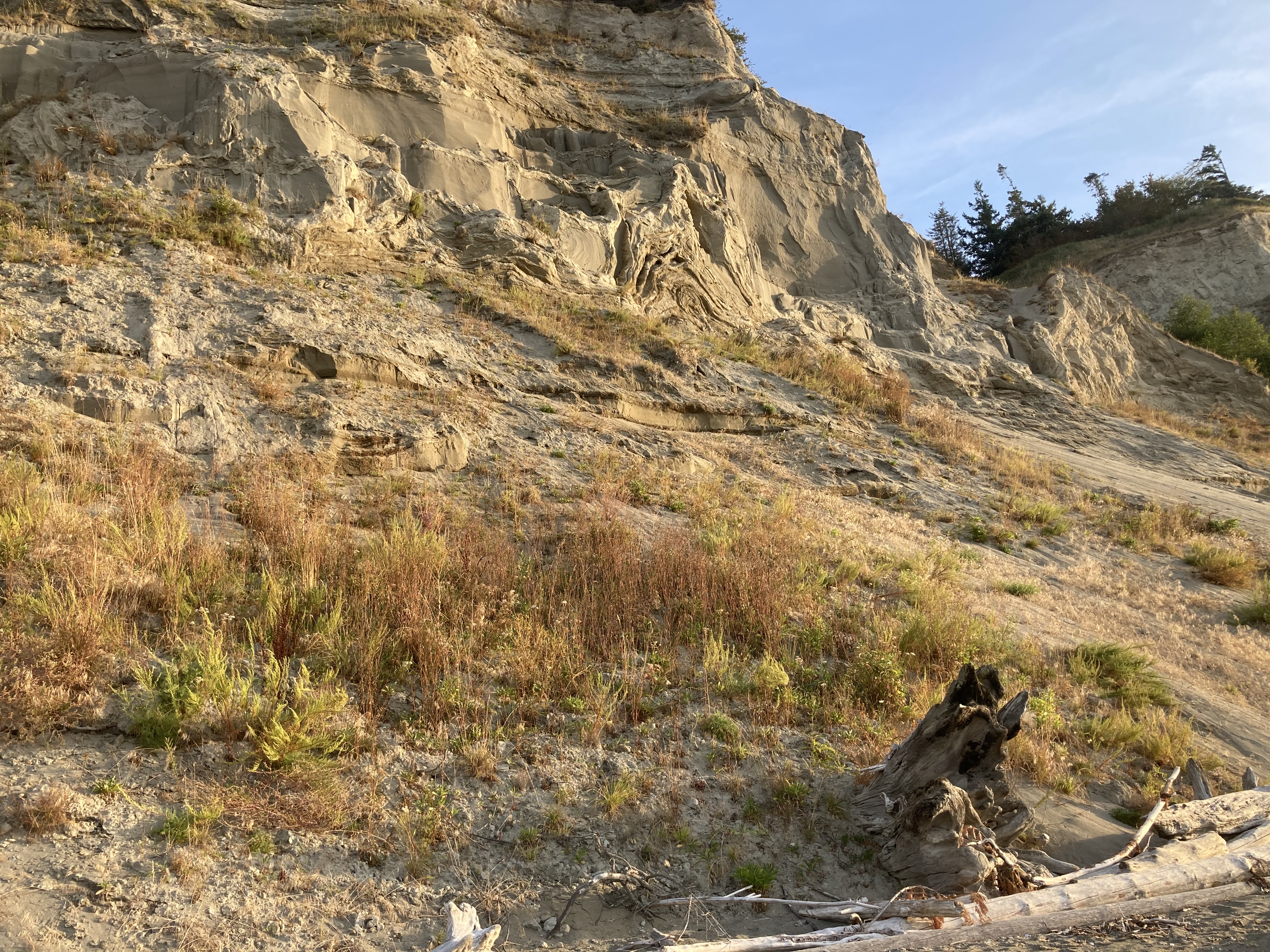
Deep Time Exposed
The bluffs at Double Bluff are a geological layer cake sliced open by wind, rain, tides, and the tectonic grinding of the South Whidbey Island Fault. The oldest visible layer dates to the Double Bluff Glaciation, between 150,000 and 200,000 years ago, when massive ice sheets advanced across the Puget Sound lowlands. At the very top sits drift from the Possession Glaciation, roughly 70,000 years old. Between these two ice age bookends lies the Whidbey Formation, an interglacial layer of silt, clay, sand, and compressed peat deposited by lakes and rivers that filled the basin before the Pacific Ocean flooded it. The formation makes up most of the visible bluff face, a crumbling record of a world between glaciers. Poorly sorted sediments tumble down the cliff in ongoing erosion, sometimes carrying fragments of the Pleistocene with them.
Where the Tide Walks Away
At the southern end of Double Bluff Beach, the shore faces Useless Bay, a body of water whose name understates its beauty. Fed by sand from the bluffs at both ends, the bay has an extraordinarily shallow, sandy slope. At low tide, the water retreats so far that the horizontal distance between the high and low tide lines can exceed 2,500 feet, nearly half a mile of wet sand and tidal flats. You can walk out into what was ocean an hour ago and find yourself surrounded by a flat expanse that feels more like a desert than a seashore. To the south, across Puget Sound, the skyline of Seattle rises 30 miles away, dwarfed by Mount Rainier looming another 70 miles beyond. To the west, Useless Bay opens into Admiralty Inlet and the Olympic Mountains fill the horizon.
Raptors and Tidepools
The beach and bluffs support a rich corridor of wildlife that takes advantage of the collision between land, sea, and sky. Bald eagles nest in the old trees atop the bluffs and hunt along the shoreline. Peregrine falcons, the fastest animals on earth, patrol the cliffs. Great blue herons stand motionless at the water's edge, waiting for fish to make mistakes. Osprey dive from altitude into the shallows. At lower tide, the beach reveals a different ecosystem entirely: sea anemones grip rocks in the tidal pools, several species of crab scuttle across exposed sand, and sea urchins and barnacles cluster on every hard surface the water abandons. River otters work the transition zone between fresh and salt water, slipping between kelp beds and driftwood logs.
Driftwood Architecture
Double Bluff Beach is one of those rare public spaces where visitors have quietly invented their own traditions. The beach is famous for its driftwood shelters, improvised huts and lean-tos built by generations of beachgoers from the abundant logs that wash ashore. Some are crude windbreaks. Others are elaborate constructions with walls, benches, and doorways, temporary architecture that survives until the next winter storm rearranges the shoreline. The beach is also one of Whidbey Island's most popular off-leash dog areas, and on any given afternoon the sand is dotted with retrievers chasing sticks into the surf and small dogs investigating crab shells with intense suspicion. Two miles from the retail core of Freeland, the beach feels worlds away from anything commercial, a place where the primary activities are walking, watching birds, exploring tidepools, and building things that the sea will eventually reclaim.
From the Air
Located at approximately 48.00°N, 122.51°W on the southern shore of Whidbey Island. The beach runs along the north side of Useless Bay, with the distinctive white-faced bluffs visible from altitude. At low tide, the massive tidal flats of Useless Bay are dramatically visible. Best viewed from 2,000-4,000 ft AGL. Nearest airports: W10 (Whidbey Airpark, 8 nm N), KPAE (Paine Field, 20 nm SE), 2W1 (Langley Airport, 5 nm NE).