Dover Castle
Somewhere beneath the white cliffs of Dover, in a tunnel carved fifteen metres into the chalk, Admiral Sir Bertram Ramsay sat at his desk in May 1940 and directed the rescue of an army. Operation Dynamo -- the evacuation of 338,000 Allied soldiers from the beaches of Dunkirk -- was planned and coordinated from these underground passages, originally dug during the Napoleonic Wars to house troops defending the English coast. That a Roman lighthouse, a medieval fortress, and a Second World War command centre could all occupy the same clifftop is Dover Castle's essential story: this has been the most strategically important point in England for two thousand years, and every generation has added its own layer of defiance.
The Oldest Light in England
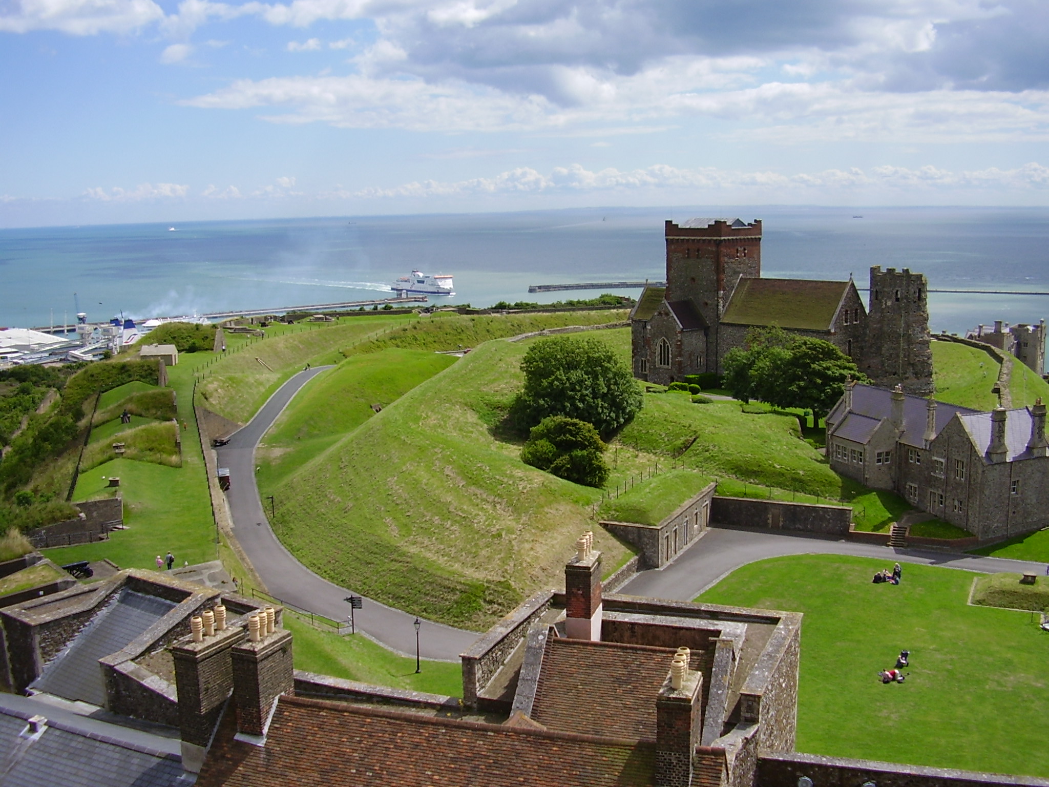
Dover Castle contains one of only three surviving Roman-era lighthouses in the world, and it is the tallest and most complete standing Roman structure in England. Built in the early 2nd century, the five-level octagonal tower was constructed from layers of tufa, Kentish ragstone, and red brick. Some historians argue it is Britain's oldest standing building. Its partner once stood across the English Channel at Boulogne-sur-Mer -- the Tour d'Ordre, built around AD 39, possibly by order of the Emperor Caligula in preparation for an invasion of Britain that never materialized. The Roman historian Suetonius described the Boulogne lighthouse as 'a tall lighthouse, not unlike the one at Pharos, in which fires were to be kept going all night as a guide to ships.' Coastal erosion toppled the French tower into the sea in 1644, but the Dover pharos endures, standing beside the Saxon church of St Mary in Castro within the castle walls.
The Norman Keep
After the Battle of Hastings in October 1066, William the Conqueror marched to Dover before continuing to London for his coronation. He recognized what the Romans had known: whoever held Dover controlled the shortest crossing to the Continent. The castle began to take its current form under Henry II, who between 1179 and 1188 spent over 6,500 pounds on construction -- an extraordinary sum when the entire royal annual revenue was likely around 10,000 pounds. The great keep, built by Maurice the Engineer, became the castle's dominant feature. In 1216, during the First Barons' War, rebel barons invited the future Louis VIII of France to take the English crown. French forces breached the northern gate but could not capture the castle. The defenders tunnelled outward and counterattacked. After the siege, the vulnerable north gate was converted into an underground forward-defence complex, and new gates were built into the outer curtain walls -- lessons in resilience literally carved into stone.
Tunnels Beneath the Chalk
The Napoleonic Wars transformed Dover from a medieval fortress into a modern military installation. William Twiss, the Commanding Engineer of the Southern District, remodelled the outer defences by adding massive bastions for artillery, strengthened the northern spur with a raised gun platform, and -- most consequentially -- carved a network of barracks tunnels into the cliffs. The first troops were accommodated in these underground passages in 1803, making Dover the only castle in Britain with subterranean barracks. When the Second World War broke out in 1939, the tunnels were repurposed first as an air-raid shelter, then as a military command centre and underground hospital. It was from these chalk corridors that Ramsay orchestrated the Dunkirk evacuation, coordinating a flotilla of destroyers, merchant vessels, and civilian boats across the Channel while German forces closed in on the beaches.
The Key That Never Turned
Dover Castle has been called the 'Key to England' since at least the medieval period, and the title endures because the lock has never been picked. The castle withstood French siege in 1216, survived the English Civil War by the narrowest of margins -- in 1642, a local merchant named Richard Dawkes and ten men scaled the cliffs at night, overpowered the porter, and seized the castle for Parliament without a single shot -- and served as a potential nuclear shelter during the Cold War, designated as a Regional Seat of Government. After the war, the tunnels were prepared to shelter civilian officials in the event of atomic attack. Between 2007 and 2009, English Heritage spent 2.45 million pounds recreating the castle's interior for visitors. Today, some 368,000 people visit annually, climbing the same steep path that Norman knights, Tudor soldiers, and Napoleonic gunners once walked. The Roman lighthouse still stands. The chalk tunnels remain. The Lord Warden of the Cinque Ports serves as the castle's official head, a title that stretches back to the days when Dover guarded England against every threat that crossed the Channel.
From the Air
Located at 51.13N, 1.32E on the white cliffs above Dover, Kent. The castle is prominently visible from the air, particularly the massive Norman keep and the surrounding fortifications on the clifftop above the port. The Roman lighthouse is visible within the castle walls. Dover Harbour and the ferry terminal are immediately below to the southwest. Nearest airport: Lydd (EGMD), approximately 15 nm to the southwest. The French coast is visible on clear days, approximately 21 nm across the Channel. Best viewed at 2,000-3,000 ft AGL.