Dovrefjell-Sunndalsfjella National Park
The musk oxen arrived in 1947, ten calves shipped from Greenland to a mountain plateau where their kind had been extinct for thousands of years. It was an audacious experiment: reintroduce an Ice Age species to a landscape that still looked like the Ice Age. Nearly eight decades later, the experiment has succeeded almost too well. The shaggy, short-tempered animals now number in the hundreds across the Dovrefjell-Sunndalsfjella National Park, and they have become both the park's most iconic residents and its most dangerous. They do not flee from hikers. They form defensive circles. They charge. The 200-meter minimum distance rule is not a suggestion.
An Alpine Ark
Established in 2002 to replace and greatly expand the original Dovrefjell National Park of 1974, Dovrefjell-Sunndalsfjella encompasses 1,693 square kilometers across three Norwegian counties: Innlandet, Trondelag, and More og Romsdal. When the surrounding landscape-protected and biotope-protected areas are included, the total protected zone reaches 4,366 square kilometers -- one of the largest contiguous conservation areas in northern Europe. The park was created with a straightforward purpose: preserve an intact alpine ecosystem with its indigenous wildlife. That ecosystem includes the wild Fennoscandian reindeer of possible Beringia origin -- genetically distinct from domesticated herds -- as well as wolverines, golden eagles, gyrfalcons, and the musk oxen. Arctic foxes, once common, went extinct in the area around 1990, but a reintroduction program launched in 2010 has so far proven successful. Some of the park's plant species predate the last ice age.
Snohetta's Domain
The park's highest point is Snohetta, at 2,286 meters the dominant summit of the Dovrefjell range and once believed to be Norway's tallest mountain. That title eventually went to Galdhopiggen in Jotunheimen, but Snohetta remains one of the most challenging and rewarding climbs in the country. The terrain around it is stark: long distances between mostly unstaffed mountain huts, large areas without any trails at all, and weather that can turn from clear skies to driving snow within an hour. The park is explicitly recommended for experienced and well-equipped hikers only. For those who accept the challenge, the reward is a landscape of extreme solitude -- ridgelines where you can walk for hours without seeing another person, valleys where the only sound is wind and the occasional distant call of a golden eagle.
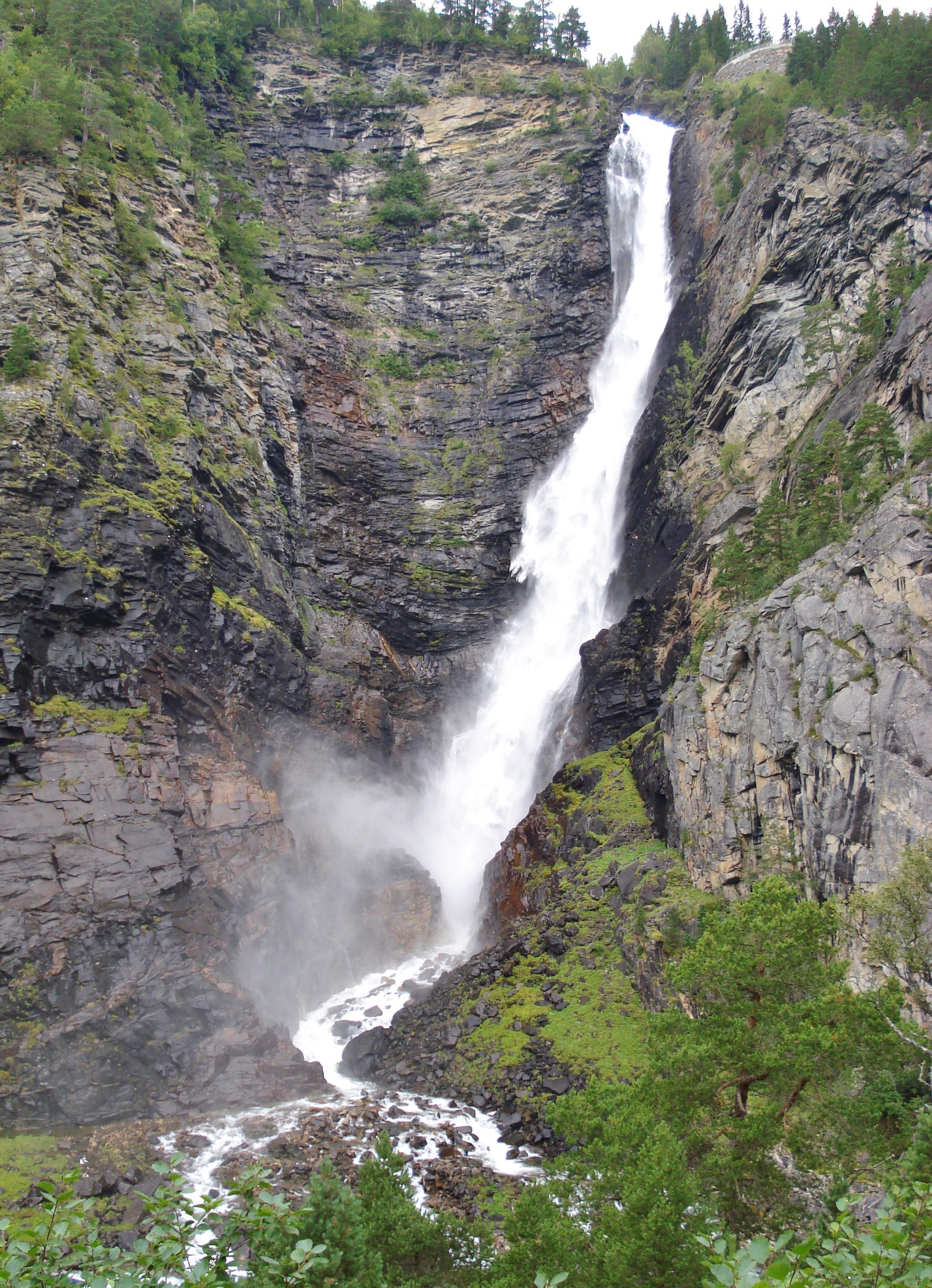
The Waterfall at Amotan
At the park's northern edge, where Road 70 runs between Oppdal and Sunndalsora, the landscape delivers a spectacle that breaks from the plateau's usual restraint. The waterfall at Amotan plunges 156 meters into a canyon -- one of the most powerful single drops in Norway. It sits at the border of the Amotan-Grovudalen Landscape Protected Area, accessible from the road but wild enough to feel like a discovery. The park's geography is divided by the E6 highway and the Dovre Line railway, which run parallel through the range, splitting it into a larger western section and a smaller eastern portion. This transportation corridor has been the primary route between Oslo and Trondheim for centuries, and the contrast is vivid: modern trains and trucks passing through a landscape that is managed, deliberately, to remain as close to its prehistoric state as possible.
Managed by Mayors
Dovrefjell-Sunndalsfjella has an unusual governance model. The National Park Board consists of political representatives -- typically the mayors -- from the eight municipalities and four counties that the park spans. They are nominated locally and appointed by the Ministry for the Environment, giving the park a distinctly democratic management structure. This model, formalized in 2011 after years of trial arrangements, reflects a Norwegian principle: the people who live closest to a landscape should have the strongest voice in how it is managed. The board coordinates not only the national park itself but also the five adjacent landscape-protection areas and two biotope-protected zones. Day-to-day management follows the European Charter for Sustainable Tourism, balancing access with conservation. The result is a park where hikers are welcome but infrastructure is deliberately minimal, where the goal is not to make the wilderness convenient but to keep it wild.
From the Air
Located at 62.40N, 9.17E spanning three Norwegian counties. Snohetta (2,286 m) is the park's dominant peak, visible from considerable distance. The E6 highway and Dovre Line railway bisect the park, running the historic Oslo-Trondheim corridor. The 156 m Amotan waterfall is at the northern edge near Road 70. Nearest airports: Trondheim Airport Vaernes (ENVA) approximately 80 nm north, Molde Airport Aro (ENML) approximately 60 nm northwest. The park's vast treeless plateau is unmistakable from altitude -- look for the contrast between bare alpine terrain and the forested valleys that border it. Musk oxen herds are occasionally visible as dark clusters on the open plateau.