Drysdale River National Park
There is no road in. No rangers patrol its gorges. No fuel station, no food, no mobile signal. To reach Drysdale River National Park, you need permission from the Kalumburu Aboriginal Corporation, a reliable four-wheel drive, and a particular tolerance for the kind of silence that accumulates over millennia. This is the largest park in the Kimberley — and also the least visited, a fact that has preserved it in a state of extraordinary wildness.
A Landscape Without Concessions
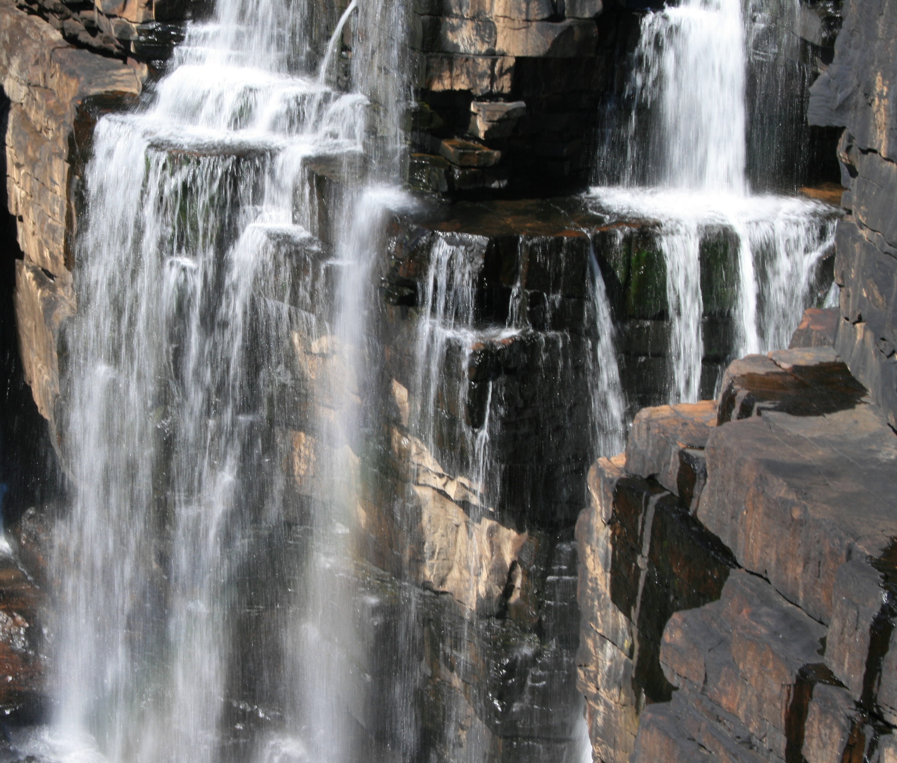
Drysdale River National Park covers a vast stretch of northern Western Australia, sitting roughly 100 kilometres south of Kalumburu and 150 kilometres west of Wyndham. The park has no marked walking trails, no visitor facilities, and no services of any kind at the nearby Carson River Station either. Getting there requires taking the track from Carson River Station off the Kalumburu Road — itself a long, rough passage through some of Australia's most remote terrain. What greets those who make the effort is a landscape that has refused to be tamed: open woodland giving way to deep gorges and vertical cliffs, the Drysdale River threading through it all in a chain of permanent pools, waterfalls, and rocky creeks. Morgan Falls and Solea Falls are the largest of the cascades, but dozens of smaller falls tumble along the river's course during the wet season, when the northern sky opens up and the land drinks deep.
A World of Living Things
The park's ecological richness is staggering for a place so rarely visited. Scientists have catalogued nearly 600 species of plants within its boundaries — around 30 of them aquatic varieties that live in the permanent pools along the Drysdale and Carson Rivers. About 25 species of fern thrive here, two of which exist nowhere else on Earth. Fan palms, kalumburu gums, and paperbarks line the watercourses in dense corridors of green. The fauna list runs just as deep: more than 100 species of birds, sugar gliders, bats, wallabies, and the ever-present saltwater crocodiles that claim the deeper pools. The tropical savanna climate — a short, fierce wet season from November to mid-April, then a long dry from mid-April to October — drives the rhythms of this ecosystem. Temperatures swing from extremes, recorded as high as 44 degrees Celsius and as low as 1.6 degrees, ensuring only the adaptable survive.
The Peoples Who Have Always Been Here
Long before European surveyors arrived, the Ngarinjin, Miwa, and Wilawila peoples held these lands. They are the traditional owners of the country the Drysdale River flows through, and their connection to it stretches back far beyond the 1886 arrival of C. A. Burrowes — a surveyor for a squatting company who was the first European to record visiting the area. Brockman and Crossland each returned in separate expeditions in 1901. The first vehicular track wasn't pushed through until 1954, connecting Gibb River Station to Kalumburu. The park was formally gazetted in September 1974, following boundaries originally recommended by an Australian Academy of Science committee nearly two decades earlier in 1955. The fact that even today it requires permission from the Kalumburu Aboriginal Corporation to enter speaks to a continued, living relationship between the land and its traditional custodians.
The Weight of Remoteness
What makes Drysdale River National Park worth knowing about — even if you'll never visit — is what its inaccessibility has preserved. In a continent where the largest parks often become synonymous with infrastructure and visitor management, Drysdale remains stubbornly itself. No crowds gather at the waterfalls. No interpretive signs explain the ferns. The crocodiles in the permanent pools have not become accustomed to people. The park exists on its own terms: as a working example of what the Kimberley looked like before roads arrived, a benchmark of ecological wholeness in a region that has seen a great deal of change. For those who do reach it, crossing the threshold requires something more than planning — it requires a willingness to enter a landscape that has not been adjusted to accommodate you.
From the Air
Located at 15.16°S, 126.78°E in the Kimberley region of northern Western Australia. Viewing altitude of 3,000–8,000 feet reveals the gorge system and river corridors clearly. The Drysdale River's course is visible as a dark green thread through open red-and-ochre savanna. Nearby reference point: Kalumburu, approximately 100 km to the north. Closest airstrip is at Kalumburu (YKBU). Weather is clearest during the dry season (May–October); the wet season brings cloud cover but dramatically transforms the landscape.