Dyea Ghost Town
In 1897, Dyea didn't exist. In 1898, it had 10,000 residents, dozens of hotels, saloons, and businesses, and was one of the most important towns in Alaska. By 1900, it was dead. Dyea was the starting point of the Chilkoot Trail, the brutal 33-mile route to the Klondike goldfields that required stampeders to carry a year's worth of supplies over a 3,500-foot pass in winter. For one frantic year, the town thrived on outfitting, housing, and fleecing the thousands who poured through on their way to the gold. Then the competing town of Skagway completed a railroad over a different pass, and Dyea's reason for existing vanished overnight. Buildings were dismantled and shipped to Skagway. The population left. Today, almost nothing remains - a few foundations, some rusting equipment, and the starting trailhead for the Chilkoot.
The Boom
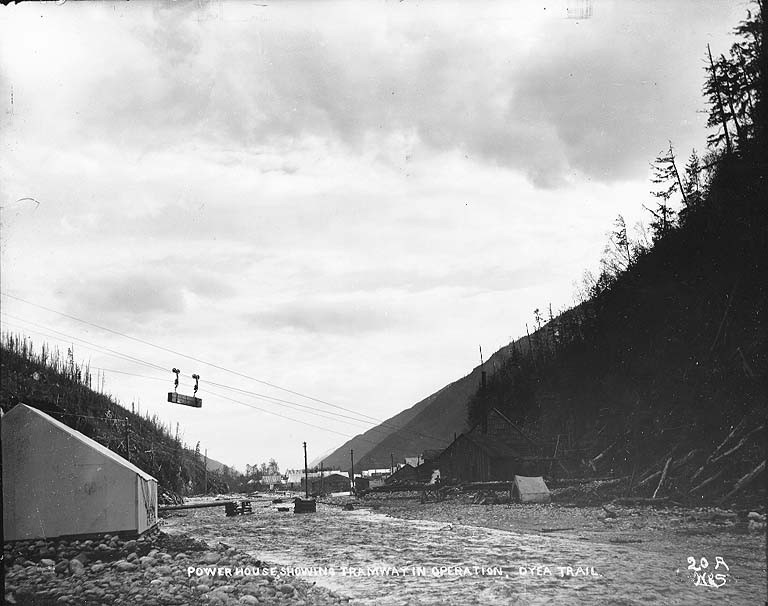
The Klondike Gold Rush exploded in 1897 when ships arrived in Seattle and San Francisco with literal tons of gold. Within months, 100,000 people headed for the Yukon. The quickest route started in Southeast Alaska, crossed the coastal mountains, and followed rivers to Dawson City. Dyea sat at tidewater, the end of the ocean voyage and the beginning of the Chilkoot Trail. Entrepreneurs rushed to serve the stampeders. Hotels, restaurants, outfitters, saloons, and brothels materialized from nothing. Tlingit packers, Chilkat people who had used the trail for centuries, found themselves in sudden demand. Dyea became a metropolis of tents and hastily built wooden structures.
The Trail
The Chilkoot Trail was 33 miles of misery. From Dyea, stampeders climbed through rainforest, then subalpine terrain, to the notorious 'Golden Stairs' - 1,500 steps carved in snow and ice, climbing 1,000 feet in less than a mile. At the summit, Canadian Mounties required each person to have a year's supply of goods (about a ton per person) before entering Canada. This meant most stampeders made 30-40 trips, carrying 50-pound loads up and down the pass throughout the winter. At the bottom, Dyea processed this human torrent - selling supplies, housing exhausted travelers, and taking their money by whatever means available.
The Collapse
Skagway, 6 miles south, competed with Dyea from the start. Its harbor was slightly better; its pass - the White Pass - was slightly lower. In 1898, construction began on the White Pass & Yukon Railway, which would eliminate the need for stampeders to carry their own supplies. The railroad reached the summit in 1899 and the lakes beyond in 1900. Overnight, the Chilkoot Trail became obsolete. Why carry a ton of supplies over a mountain when you could ship them by rail? Dyea's population fled to Skagway or continued to the goldfields. Buildings were dismantled for lumber. By 1902, the town was effectively abandoned.
The Ghost Town
Today, Dyea is part of Klondike Gold Rush National Historical Park. Almost nothing survives above ground. The forest has reclaimed the townsite; you can walk past foundations without noticing them. A few scattered ruins remain: the false-front facade of a building, rusting wagon wheels, the outline of the old wharf. The slide cemetery, where victims of the April 1898 avalanche that killed 70 people on the Chilkoot Trail were buried, is maintained. The National Park Service has stabilized some ruins and marked historical locations. But nature has largely erased Dyea - a complete metropolis returned to wilderness in a century.
Visiting Dyea
Dyea is located 9 miles northwest of Skagway, Alaska, accessible via Dyea Road (which can be rough). The area is undeveloped - there are no facilities at the townsite. The Chilkoot Trail trailhead is here; the trail itself is a 33-mile backcountry route requiring permits and preparation. The slide cemetery and scattered ruins can be explored on short walks. Rangers occasionally lead guided walks from Skagway. The Alaska State Ferry and cruise ships serve Skagway. Juneau, 80 air miles south, has the nearest commercial airport. The best way to understand Dyea is to stand at the empty townsite, look up at the Chilkoot Pass looming to the north, and imagine 10,000 people where only forest stands now.
From the Air
Located at 59.50°N, 135.35°W at the head of the Taiya Inlet in Southeast Alaska. From altitude, Dyea appears as a river delta at the head of a fjord, surrounded by dense forest with the Chilkoot Pass visible to the northeast. No structures are visible; the townsite has returned entirely to forest. Skagway is visible 6 miles to the south along the inlet. The Chilkoot Trail is a barely visible trace climbing through the forest toward the pass. Juneau, the capital, is 80 air miles to the south. The terrain is dramatic coastal Alaska - steep mountains, fjords, and temperate rainforest.