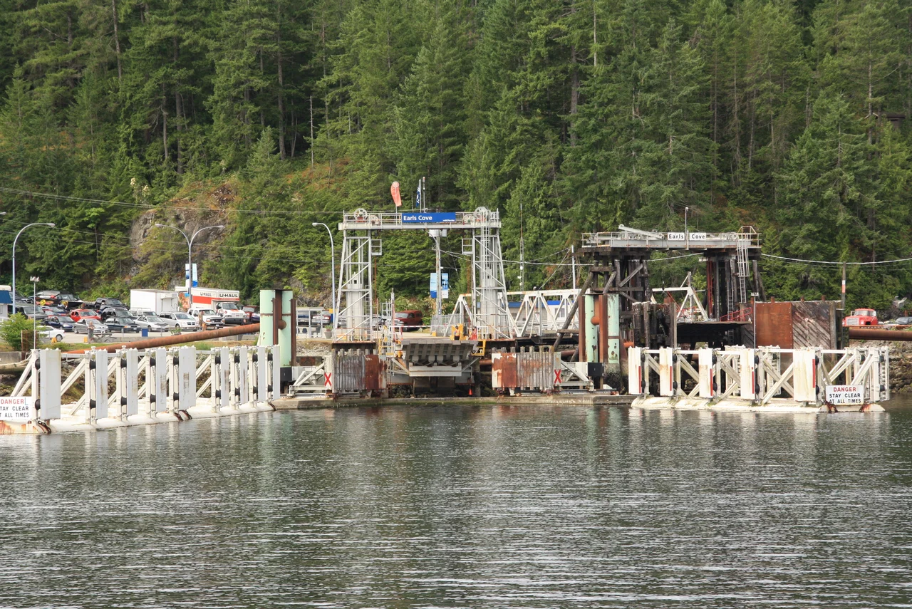

Earls Cove, British Columbia
The apostrophe was removed on purpose. When the name of this small settlement at the north end of the Sechelt Peninsula was made official, the community asked that it be spelled Earls Cove rather than Earl's Cove - not because anyone was uncertain about the pioneer named Earl who inspired it, but because there were several Earl families in the area and singling out one of them seemed unfair. It is a very small correction. It is also a fairly precise portrait of the place: a settlement of a few dozen buildings where everyone knows whose name is on what.
The Highway That Keeps Getting Interrupted
British Columbia's Sunshine Coast is mainland, but you cannot drive to it. Mountains and fjords block the way, so the road network arrives by boat. From the Lower Mainland, BC Ferries runs from Horseshoe Bay to Langdale, where Highway 101 picks up and runs northwest toward the coast's far end at Lund. Roughly midway along that stretch, the highway simply stops at Earls Cove, and passengers roll onto a ship for the crossing to Saltery Bay before the pavement resumes. Vancouver is 136 kilometres away - about 85 miles - which on any ordinary highway would be ninety minutes and a coffee stop. Here it is a sequence of sailings, and the schedule is a fact of life that shapes dinner plans, medical appointments, and the local sense of time.
Fifty Minutes Across the Mouth
The Earls Cove terminal has two berths and a single job: linking Highway 101 across the mouth of Jervis Inlet to Saltery Bay on the far shore, joining the Lower Sunshine Coast to the Upper. The route is about 9.5 nautical miles and takes around fifty minutes, worked by the MV Malaspina Sky. It is, by a comfortable margin, one of the most scenic commutes in Canada. Steep forested walls drop straight into deep green water on both sides, with Nelson Island filling the view across Agamemnon Channel to the west. Captain George Vancouver explored this inlet in 1792, and from the deck of the ferry the shoreline he charted looks very much as he would have found it - the timbered slopes, the rock, the low cloud catching in the trees.
Two Thousand Feet of Water
Jervis Inlet is the deepest fjord on the British Columbia coast, reaching about 670 metres - some 2,200 feet - of water. That number is hard to hold in your head while looking at a channel that from the surface seems merely narrow. Glaciers gouged it, the sea filled it, and the result is a trench bending inland for dozens of kilometres toward Princess Louisa Inlet. The naming on the chart comes from the Royal Navy: in 1860 Captain George Henry Richards of HMS Plumper named Agamemnon Channel for the sixty-four-gun ship that was Horatio Nelson's first ship of the line, and gave Nelson's own name to the island beside it. Two centuries later those names sit on a working ferry route, printed on schedules and repeated over the public address system.
Lakes, Lagoon, and Trail
Behind the cove the land opens into freshwater country. Sakinaw and Ruby lakes both hold trout in season and are quiet enough for canoes and kayaks to have the surface mostly to themselves. Ruby Lake Lagoon supports more than eighty bird species along with painted turtles, beavers, otters, elk, deer, and bears - a concentrated piece of coastal habitat that rewards sitting still. Just east of Earls Cove, at Klein Lake, is the northern terminus of the Suncoaster Trail, a 33-kilometre route popular with hikers and mountain bikers. Provincial parks are scattered through the area, including Musket Island Marine Park offshore, and the Ambrose Lake Ecological Reserve protects a small coastal lake with its adjoining bog and forest, open for walking and watching but nothing more intrusive than that.
Why People Stay
The Sunshine Coast mostly earns its name. Winters here are mild and wet, summers noticeably drier than the rest of this coastline, with average temperatures running from about 4°C in January to 18°C in July. Annual rainfall is around 100 centimetres and snowfall is light enough that it counts as an event rather than a season. That combination has drawn retirees and seasonal residents for decades, people who wanted salt water, forest, and a climate that does not demand much of them. The trade-off is the ferry, always the ferry - and for the people who choose to live here, that is generally considered a feature rather than a defect.
From the Air
Earls Cove lies at 49.7519°N, 124.0092°W, at the northern tip of the Sechelt Peninsula on British Columbia's Sunshine Coast. From the air the site reads clearly: Jervis Inlet drives inland to the northeast as a long, straight, steep-walled fjord, Agamemnon Channel runs southeast between the peninsula and Nelson Island, and the ferry terminal sits on the east side of the inlet mouth with Highway 101 ending at its ramps. Saltery Bay is visible across the water to the northwest. Recommended viewing altitude is 4,000-6,000 ft MSL to trace the fjord walls and channel geometry, or 10,000 ft and above to see Jervis Inlet reach back toward the Coast Mountains and Princess Louisa Inlet. Powell River Airport (CYPW) is roughly 20 nm northwest, Sechelt Aerodrome about 20 nm southeast, and Vancouver International (CYVR) approximately 45 nm south. Fjord walls generate mechanical turbulence and funnelled winds in this terrain, and low cloud commonly fills the inlet in winter; summer mornings are typically the clearest.
Nearby Stories
- Powell River, British Columbia 5.1 km away
- Halfmoon Bay, British Columbia 6 km away
- Malibu Hydro 6.2 km away
- Hornby Island 16 km away
- Desolation Sound Marine Provincial Park 17 km away
- Bowen Island 21 km away
- Sea to Sky Gondola 26 km away
- Whistler 31 km away