East Point Lighthouse
It took shipwrecks to build it. Recommendations for a lighthouse at the eastern tip of Prince Edward Island date to 1851, but bureaucracy and budgets delayed the project for more than fifteen years while vessels continued to founder on the shoals. By the time William MacDonald finally raised the octagonal wooden tower in 1867, the year of Canadian Confederation, the need had been proven in hull timber and lost cargo. The coincidence of its construction date earned the lighthouse a nickname that has outlasted every keeper who tended its flame: Canada's Confederation Lighthouse.
A Light That Moved
The East Point Lighthouse has not always stood where it stands today. In 1882, the wreck of HMS Phoenix revealed that the navigational charts of the time were wrong -- the light was in the wrong place, or rather the charts had placed the point in the wrong place, and the light was dutifully leading mariners into danger rather than away from it. The solution, carried out in 1885, was blunt and physical: the entire lighthouse was moved roughly 490 metres from its original position on the south side to the actual point itself. It was moved again in 1908, this time to accommodate a separate building for the fog horn. The land the lighthouse was originally built on no longer exists. The sea has taken it.
The Keepers' Centuries
For 122 years, a human being climbed the 67 steps of the East Point Lighthouse to tend its light. The roster of keepers reads like a genealogy of the island's Scottish and Irish families: Alexander R. Beaton served two separate terms spanning three decades, from 1867 to 1897. The MacDonald family held the post for another stretch. Angus C. MacIntyre took over in 1912 and passed the duty to his son Wilbert Stewart MacIntyre, who kept the light for 37 years until 1963. Harry James Harris was the last keeper, serving from 1963 until automation claimed the position in 1989. Each man lived in the keeper's dwelling beside the tower, watching the Gulf of St. Lawrence in all its moods -- the summer calms when the water turned turquoise, the autumn gales that built seas large enough to shake the windows, the winter ice that locked the coast in silence.
Where Two Tides Collide
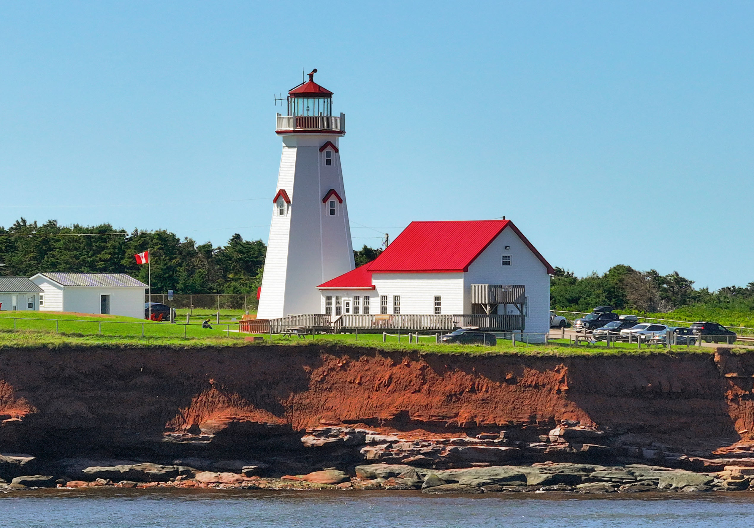
East Point is where the Northumberland Strait and the Gulf of St. Lawrence meet, and the collision of their tidal currents creates a visible turbulence off the point that mariners have respected for centuries. The 19.5-metre tower stands at the absolute easternmost tip of Prince Edward Island, the end of the island in every sense. The octagonal wooden structure is shingled on the outside, its lantern platform supported by decorative fascia and surrounded by a wooden railing. Each window is topped by a triangular pediment -- small architectural flourishes on a building designed primarily to be seen from miles at sea. The tower's light, automated since 1989, still operates, its beam sweeping across waters where fishing boats work the same grounds their predecessors did when the first keeper lit the lamp in 1867.
Guarding the Edge
Since 2002, the Friends of Elmira have operated the lighthouse as a heritage site, opening the tower to visitors who climb the 67 steps for panoramic views of the island's end. The landscape here is wilder and less populated than the tourist beaches of the north shore. Red cliffs drop to rocky shores where the water churns white over submerged sandstone ledges. On clear days, the view from the lantern platform stretches to the distant smudge of Cape Breton Island to the east and the Magdalen Islands to the north. The lighthouse is part of a broader constellation of lights around the island -- PEI has more lighthouses per kilometre of coastline than almost anywhere in Canada -- but East Point's position at the island's far tip, where the land simply runs out, gives it a finality the others lack. It marks not just a hazard but an ending.
From the Air
Located at 46.45N, 61.97W at the extreme eastern tip of Prince Edward Island. The lighthouse is easily spotted from the air as a white octagonal tower on the narrow point where the island ends and the Northumberland Strait meets the Gulf of St. Lawrence. Visible tidal rips off the point are often apparent from low altitude. Nearest airport: Charlottetown (CYYG), approximately 80 km west-southwest. East Point makes an excellent visual waypoint when approaching PEI from the east or navigating the Northumberland Strait. Best viewed at 1,500-2,500 feet AGL.