East Texas Oil Field
Eight thousand people stood in a muddy East Texas pasture on October 3, 1930, watching a rickety wooden derrick shudder over a hole that everyone -- geologists, investors, neighbors -- said would produce nothing. Then oil gushed over the top. The Daisy Bradford No. 3, named after the widow who owned the farm, had just tapped into the largest oil reservoir ever discovered in the contiguous United States. Within months, the quiet piney woods of Rusk, Gregg, Upshur, Smith, and Cherokee counties would be transformed into a forest of steel derricks, and downtown Kilgore would pack over 1,000 active oil wells into a few city blocks -- the densest oil development the world had ever seen.
Dad Joiner's Stubborn Gamble
Columbus Marion Joiner -- known to everyone as "Dad" -- was an Alabama-born wildcatter with more persistence than geology credentials. Earlier attempts to find oil in the area had begun as far back as 1911 with the Millville Oil Company, but drilling technology could not reach the depths required. Most early ventures ended in broken drill bits, dry holes, and bankruptcy. Joiner was different only in his refusal to quit. His first well, drilled in February 1928, was abandoned. His second, spudded in March 1929, also failed, though it did show traces of gas. Undaunted, Joiner hired driller Ed Laster and started a third well in May 1929, barely a stone's throw from the previous two. On July 20, 1930, a core sample at depth revealed oil sand. By September, a drill stem test confirmed oil and gas. On October 5, the well came in at a thunderous 6,800 barrels per day, and the East Texas oil boom was born.
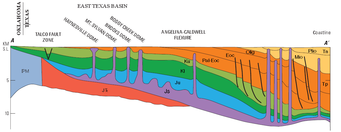
A Sea Buried in Stone
What Dad Joiner had punctured was the Woodbine Formation, a sandstone layer deposited roughly 100 million years ago when East Texas lay beneath a shallow Cretaceous sea. Over geological time, the Sabine Uplift raised the formation, erosion sculpted it, and then the sea returned, depositing an impermeable cap of Austin Chalk on top. This created a massive stratigraphic trap -- a geological arrangement where oil, being lighter than water, migrates upward until it can go no further and pools. The source rock feeding all that petroleum was the overlying Eagle Ford Shale. Water pressure from deep within the Woodbine pushed oil toward the producing wells; a 1932 study found that wells stopped flowing when pressure dropped below 800 pounds per square inch. The field itself sprawls across parts of five counties, stretching roughly 45 miles on its north-south axis and between 5 and 12 miles across.
Fortunes Made at the Baker Hotel
The discovery set off one of the great scrambles in American capitalism. H.L. Hunt, an independent oilman who had already struck it rich in the El Dorado and Smackover fields of Arkansas, arrived quickly. When Dad Joiner found himself tangled in legal disputes over his discovery, Hunt met him at the Baker Hotel in Dallas in November 1930 and bought the Daisy Bradford No. 3 well and 5,580 acres for $1.34 million. By December, Hunt's Panola Pipeline Company was pumping crude to a Missouri Pacific Railroad spur, which shipped it onward to Sinclair Oil Corporation's Houston refinery. By the summer of 1931, roughly 1,200 Rusk County wells alone were producing a staggering 900,000 barrels per day. The purchase gave Hunt the financial foundation to establish Hunt Oil Company in 1934, building one of the great American petroleum dynasties.
Slant Holes and Texas Rangers
Not everyone played fair. The frenzy of drilling attracted unscrupulous operators who drilled slanted holes from their own leases into the productive Woodbine zones beneath their neighbors' land. It was theft on a geological scale, invisible from the surface. Inspectors eventually identified 380 deviated wells, and the Texas Rangers were called in to shut them down. An estimated $100 million worth of oil was stolen over several decades from legal lease holders. The chaos of overproduction also cratered oil prices, prompting Texas Governor Ross Sterling to declare martial law in 1931 and send the National Guard to enforce production limits. The crisis ultimately led to the Texas Railroad Commission gaining authority to regulate oil output -- a power that shaped the global oil market for decades.
The Field That Changed Texas
Since its discovery, the East Texas Oil Field has produced over 5 billion barrels of oil, and originally contained more than 7 billion barrels. At modern prices, the cumulative output represents hundreds of billions of dollars in value. The field transformed sleepy farming communities into boomtowns almost overnight. Kilgore, Overton, and Gladewater -- small towns along Interstate 20 -- became household names across the oil industry. The producing sands were relatively shallow, and the oil they contained was high gravity, low in sulfur, and yielded an exceptional 37 percent gasoline. Today, the East Texas Oil Museum at Kilgore College preserves the story of the boom, and the Haynesville Shale beneath the region has drawn a new generation of gas exploration. The derricks are mostly gone now, but the wells -- over 30,000 of them historically drilled -- dot the piney woods landscape as quiet monuments to the day Dad Joiner proved everyone wrong.
From the Air
The East Texas Oil Field is centered near 32.39°N, 94.87°W, spanning parts of Gregg, Rusk, Upshur, Smith, and Cherokee counties. From the air, the field stretches roughly 45 miles north to south and is crossed east-west by Interstate 20. Look for the towns of Kilgore, Overton, and Gladewater clustered along the interstate. East Texas Regional Airport (KGGG) near Longview is the closest commercial airport. Tyler Pounds Regional Airport (KTYR) is approximately 37 nm to the west. The terrain is gently rolling piney woods with scattered oil pumpjacks visible from lower altitudes.