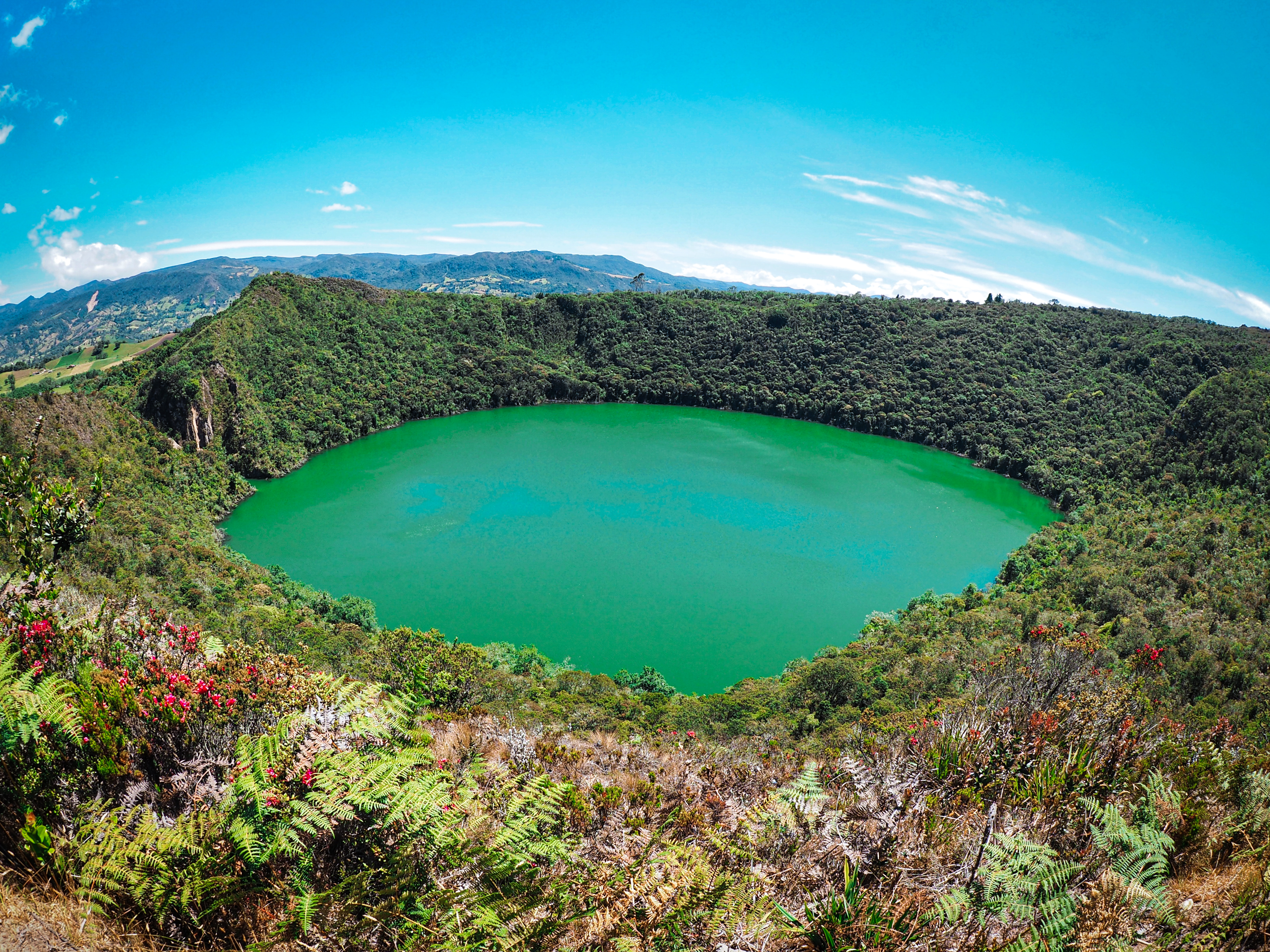
El Dorado
A new chief stands on a raft at the center of Lake Guatavita. His body is coated in gold dust. Around him, priests arrange offerings -- golden figurines, emeralds, ceramic vessels -- while thousands watch from the crater rim above. At the signal, the chief dives into the water, the gold dissolving from his skin into the dark lake. The offerings follow. This Muisca coronation ceremony, performed on a volcanic lake high in the Colombian Andes, was real. What happened next -- the century of obsession it unleashed across an entire continent -- reads like a fever dream that cost thousands of lives and reshaped the map of South America.
The Golden One
The Muisca inhabited a plateau in the Andean highlands of present-day Colombia. They were an agricultural people, organized not as a unified empire but as a loose confederation of chiefdoms. The two most powerful rulers, the zipa in the south and the zaque in the north, presided over a culture with no gold mines of its own. The Muisca acquired their gold through trade, exchanging salt and cotton blankets for raw metal that their skilled artisans worked into elaborate objects -- most of them actually tumbaga, a gold-copper alloy. Gold held deep religious significance. It decorated temples, accompanied the dead, and took the form of small anthropomorphic figures called tunjos, left as offerings in sacred lakes and caves. When the Spanish first heard about a king who covered himself in gold dust, they called him El Dorado -- the Golden One. The name would soon outgrow the man and attach itself to an entire imaginary city.
Bankers, Governors, and the Road From Coro
The search began from an unlikely place: Coro, a small coastal settlement in Venezuela governed not by Spanish nobles but by employees of the Welser banking family of Augsburg. Emperor Charles V had mortgaged Venezuela to the Welsers in exchange for loans, and their agents were eager to find a route to the Pacific -- or, failing that, gold. In 1529, Governor Ambrosius Dalfinger led the first expedition inland to Lake Maracaibo. His men looted golden trinkets from local populations and heard tales of a wealthy mountain tribe. When Dalfinger died in 1533, his deputy Nikolaus Federmann launched his own unauthorized foray south into the llanos, while Georg Hohermuth von Speyer took over as governor and led a separate expedition. All chased rumors. None found what they sought. But collectively, they mapped vast stretches of territory that Europeans had never seen.
Three Armies on One Plateau
In 1537, Gonzalo Jimenez de Quesada accomplished what the Coro expeditions could not. Leading roughly 800 men up the Magdalena River from Santa Marta on the Caribbean coast, he reached the Muisca plateau after a brutal nine-month march that killed most of his force. The survivors found a prosperous civilization -- and plundered it. Quesada marched on the zipa's palace at Bacata, modern-day Funza, but the ruler fled with his treasure. Turning north, Quesada found emerald mines at Somondoco and looted the zaque's palace at Hunza. Then, in early 1539, something extraordinary happened. Two other European armies arrived on the same plateau, almost simultaneously: Sebastian de Belalcazar marching north from Quito, and Federmann arriving from the east. Three conquistadors, three separate expeditions launched from three different directions, all converging on the same highland. Rather than fight, they agreed to sail to Spain and let the crown arbitrate their competing claims.
Down the Amazon, Across the Orinoco
The search for El Dorado did not end with the conquest of the Muisca. It metastasized. In 1541, Gonzalo Pizarro led an expedition east from Quito into the Amazon basin, searching for the golden king. When his force began starving, he sent Francisco Orellana downriver to find food. Orellana never returned to Pizarro -- instead, he became the first European to navigate the entire length of the Amazon River, emerging at the Atlantic months later. Pizarro, abandoned, staggered back to Quito with a fraction of his men. Decades later, Antonio de Berrio inherited the quest through his father-in-law's will, which stipulated that the successor must continue searching "most insistently" for El Dorado. Berrio dutifully spent years exploring the llanos and the Orinoco basin, becoming convinced the golden city lay in the highlands of Guiana. His obsession attracted the attention of Sir Walter Raleigh, who captured Berrio in Trinidad in 1595 and extracted his intelligence before launching his own expedition up the Orinoco.
The Legend That Outlived Its Origins
Raleigh never found El Dorado. Neither did anyone else, because the city never existed. The Muisca coronation ceremony was real, and gold objects recovered from Lake Guatavita -- including the famous Muisca raft, now displayed at the Gold Museum in Bogota -- confirm the ritual's historical basis. But the leap from ceremony to golden city was a European invention, fed by greed and sustained by a continent so vast it took generations to explore. What is beyond dispute is the consequence: the search drove exploration across the Andes, through the Amazon basin, up the Orinoco, and into the Guiana highlands. It cost countless Indigenous lives and reshaped South America's political geography. The legend persists today not as a place on a map but as a metaphor -- for wealth just out of reach, for the human tendency to believe that paradise lies somewhere over the next mountain.
From the Air
The article's coordinates place El Dorado at 11.39N, 69.67W, near Coro, Venezuela, reflecting the city's role as the launching point for early expeditions seeking the legendary golden city. The actual Muisca homeland and Lake Guatavita are located far to the southwest, near Bogota, Colombia (approximately 4.97N, 73.77W). From the air above Coro, look south and imagine the conquistadors' route across the Venezuelan llanos toward the Andes. Nearest airport: Jose Leonardo Chirino Airport (SVJC). The Caribbean coast and the island of Curacao are visible to the north. Recommended viewing altitude: 10,000+ feet AGL to appreciate the vast distances the expeditions covered.