El Paraiso, Peru
In 2013, a construction company sent bulldozers to flatten one of the pyramids at El Paraiso. They knocked down a structure with a 2,500-square-meter footprint, six meters high, then set the rubble on fire. Police arrived in time to save the other eleven pyramids. The companies responsible -- Alisol and Provelanz -- faced criminal charges, but the destroyed pyramid was gone, its stones scattered after standing for nearly five thousand years. That a developer could demolish part of one of the oldest monumental complexes in the Western Hemisphere speaks to a central tension at El Paraiso: it sits just a few kilometers north of Lima, swallowed by the expanding edges of a capital city of ten million people.
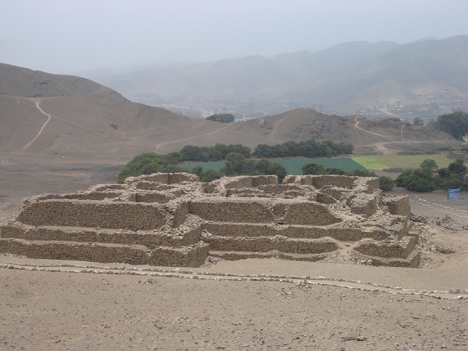
Stone Without Clay
El Paraiso dates to the Late Preceramic period, roughly 3500 to 1800 BC, making it contemporary with the early pyramids of Egypt. The name "Preceramic" is the point -- this is monumental architecture built by a society that did not yet use pottery. Frederic Engel, who first excavated the site in 1965, called the era the "Cotton Preceramic," recognizing that cotton cultivation, not ceramics, defined the period. Sprawling across 58 hectares in the Chillon River valley, the site comprises at least twelve major stone structures. Their U-shaped arrangement creates a seven-hectare central plaza, a layout that would be echoed by later Ceramic Period sites throughout the Chillon, Rimac, and Lurin valleys. The walls are built of rough-trimmed stone quarried from nearby hillsides, assembled with coarse fill and mortar, then covered in plaster. Despite its scale, El Paraiso shows no evidence of being a residential complex -- no substantial midden deposits, no cemeteries, no domestic refuse. Something else was happening here.
Children of the Humboldt Current
More than ninety percent of the protein consumed by the people of El Paraiso came from the sea. Anchovies dominated the fish remains; mussels were the most common mollusks. Terrestrial animal bones are almost entirely absent from the archaeological record. The Humboldt Current, sweeping cold, nutrient-rich water north along the Peruvian coast, created one of the most productive marine environments on Earth, and the people of El Paraiso built their society on that abundance. Cotton and bottle gourd -- cultivated not for food but for fishing nets and containers -- were among the earliest crops, dating to around 2500 BC. Agriculture served industry before it served the stomach. This maritime foundation is central to archaeologist Michael Moseley's influential theory that rich coastal fisheries, not farming, drove the early development of social complexity along the Peruvian coast.
The Lady of El Paraiso
In 2016, archaeologist Dayanna Carbonel discovered a funerary bundle in Unit IV containing the remains of a woman approximately 3,700 years old. Dubbed Eva Lucia, the Lady of El Paraiso, she appeared to be of high social status based on the context of her burial. The same excavation season produced a 4,000-year-old cactus, possibly a San Pedro specimen -- the hallucinogenic species Echinopsis pachanoi -- preserved in remarkable condition at about 30 centimeters long. These discoveries hint at dimensions of El Paraiso's culture that the architecture alone cannot tell: ritual practice, social hierarchy, and connections to the Kotosh Religious Tradition of the Central Highlands. Textile fragments found at the site reveal sophisticated craft as well -- cotton yarns in natural shades from white to dark brown, others dyed in deep reds and two distinct shades of blue. Two objects bore inlays of dark blue stone resembling lapis lazuli.
A Paradise Under Pressure
El Paraiso sits on the Rio Chillon floodplain, surrounded by over 90 hectares of arable land and 150 hectares of lowlands once capable of sustaining irrigated agriculture. It is one of six Preceramic sites in the Ancon-Chillon Valley, alongside Pampa de los Perros and Buena Vista. But unlike the remote Norte Chico sites of Aspero and Caral to the north, El Paraiso developed in relative isolation from that early civilization network. Today, its isolation has reversed into the opposite problem: engulfment. Lima's San Martin de Porres District presses against the site on all sides. The 2013 destruction of one pyramid was the most dramatic threat, but the steady encroachment of urban development continues. What remains is still extraordinary -- stone structures that represent a chiefdom-level society capable of organizing large-scale construction without centralized political authority, built by people who looked to the Pacific, not the fields, for sustenance.
From the Air
Located at 11.95S, 77.12W in the Chillon River valley, just north of central Lima, Peru, in the San Martin de Porres District. The site is approximately two kilometers inland from the coast. Nearest major airport is Jorge Chavez International (SPJC/LIM), roughly 8 km to the southwest. From altitude, the site is difficult to distinguish from surrounding urban development, but the Chillon River valley is identifiable as a green corridor cutting through Lima's northern suburbs toward the Pacific. Best viewed at 2,000-4,000 feet AGL. The Pacific coastline and the Andes foothills to the east provide orientation.