El Penon de Guatape
On the western face of the rock, a giant white "G" and what looks like an "I" are painted in letters visible from kilometers away. The "I" was supposed to be a "U" -- the beginning of "GUATAPE" -- but a mob from the neighboring town of El Penol arrived before the second stroke could be completed. That unfinished act of civic vandalism, frozen on the stone since the 1960s, captures something essential about El Penon de Guatape: this is a rock that people have been fighting over, worshipping, climbing, and claiming for centuries, and nobody has ever quite settled the question of who it belongs to.
Sixty-Five Million Years of Silence
The Tahami people, who inhabited this region of Antioquia before Spanish colonization, called the monolith Mojarra -- simply "rock" or "stone" in their language. Geologists date it to approximately 65 million years ago, making it a contemporary of the asteroid impact that ended the age of dinosaurs. The rock is an inselberg, a geological term for an isolated hill rising abruptly from the surrounding terrain, composed of quartz, feldspar, and granite. It stands 285 meters long and 110 meters wide, with its highest point reaching 2,135 meters above sea level on the southeast side. At an average temperature of 18 degrees Celsius, the summit sits in a permanent mild chill above the warmer valley floor. A mural at the entrance to La Plazoleta shows the rock floating through space alongside an astronaut, with the words: "They are leaving us behind!" Locals once believed the stone came from aliens.
The Five-Day Climb
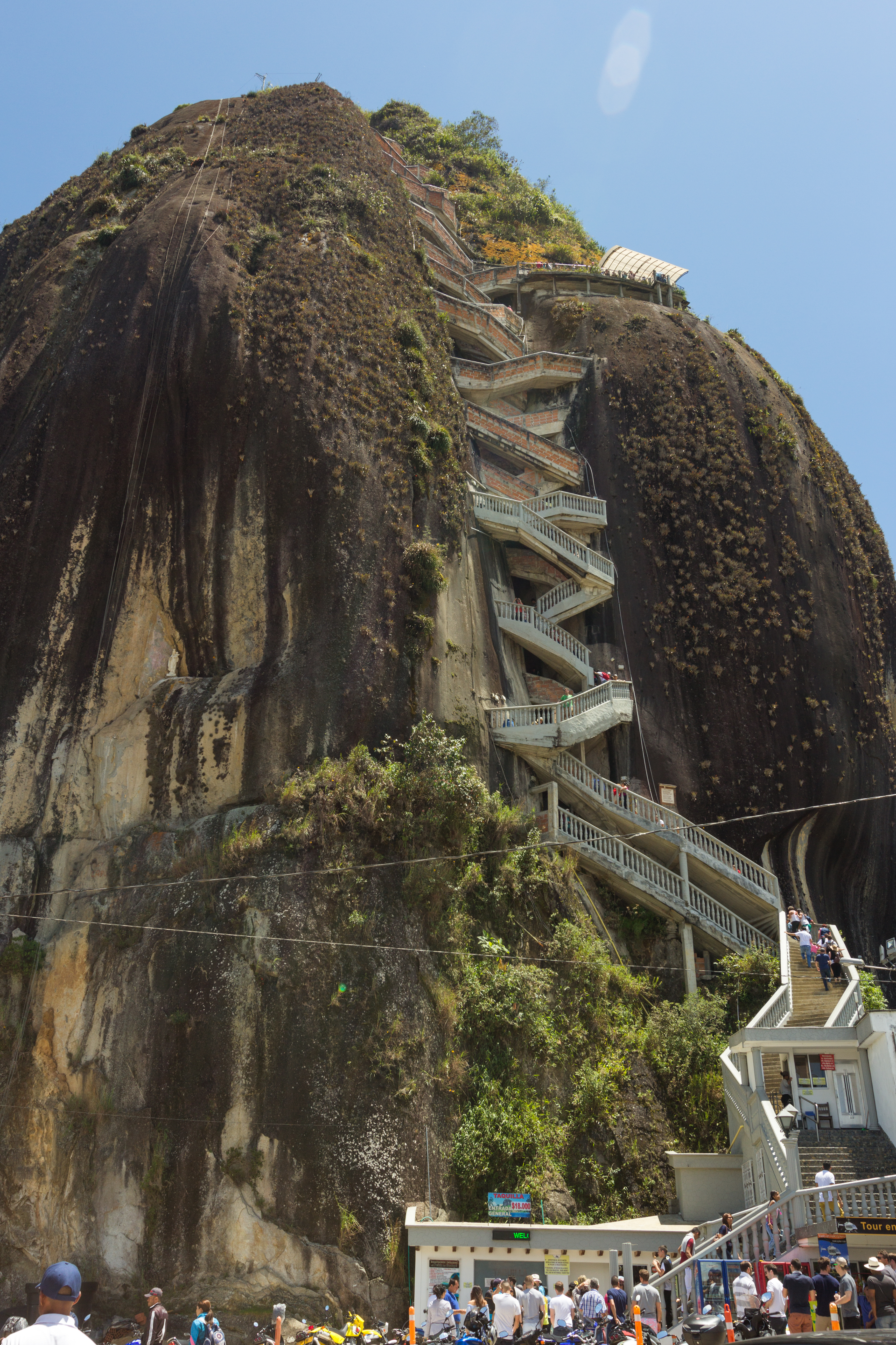
For centuries, the sheer granite walls kept humans off the summit. That changed on July 16, 1954, when Luis Eduardo Villegas Lopez, Pedro Nel Ramirez, and Ramon Diaz began a five-day ascent, wedging wooden planks into a natural fissure in the rock face and working their way upward. They were the first people known to have reached the top in historical times. Villegas saw commercial potential where local farmers saw useless land, and he purchased the rock from its owners. He built a handmade wooden staircase into the crack, later replaced by concrete steps, and began charging admission. The Villegas family continues to earn income from his investment. Today, 740 steps zigzag up the fissure, their progress marked by yellow numbers painted on each one, a countdown -- or a count-up -- that turns the geological into the personal.
Two Towns and One Rock
The rivalry between Guatape and El Penol over ownership of the monolith is the kind of dispute that defines small-town Colombia. Both municipalities claim the rock sits within their borders. In the 1960s, residents of Guatape decided to settle the matter permanently by painting their town's name in enormous white letters on the western face. They managed the "G" and the first stroke of the "U" before El Penol's citizens discovered the scheme and rushed to the site to stop it. The confrontation ended the painting but not the argument. The Colombian government sidestepped the issue in the 1940s by declaring the rock a national monument, which effectively made it belong to everyone and no one. The giant letters, incomplete and weathered, remain the most visible evidence of a territorial dispute that paint could not resolve.
The View from 740 Steps Up
From the summit, the landscape unrolls in every direction: the vast reservoir of the Penol-Guatape hydroelectric dam, with its 500-kilometer shoreline cutting a fractal pattern through green hills. The dam flooded much of the original valley in the 1970s, submerging the old town of El Penol entirely and creating the labyrinth of peninsulas and islands visible today. A small viewing platform at the top sells handicrafts, postcards, fresh fruit, and cold drinks. On clear days, the panorama extends to distant ridgelines of the Andes. In March 2024, contestants on The Amazing Race sprinted up the staircase searching for a clue hidden at the summit, introducing millions of television viewers to the breathless experience of climbing a monolith at altitude. Most visitors take it slower, pausing on the steps to catch their breath and look back at the water and hills growing wider below them.
From the Air
Located at 6.2195N, 75.1792W in the Antioquia highlands at 2,135 meters elevation. The monolith is unmistakable from the air -- a massive rounded granite boulder rising sharply from the surrounding green terrain beside the sprawling Penol-Guatape reservoir. The reservoir's complex shoreline provides excellent visual navigation reference. Nearest airport: Jose Maria Cordova International Airport (SKRG, approximately 45 km west). Best viewed at 4,000-6,000 feet AGL. The reservoir and rock combination create one of Colombia's most photogenic aerial scenes.