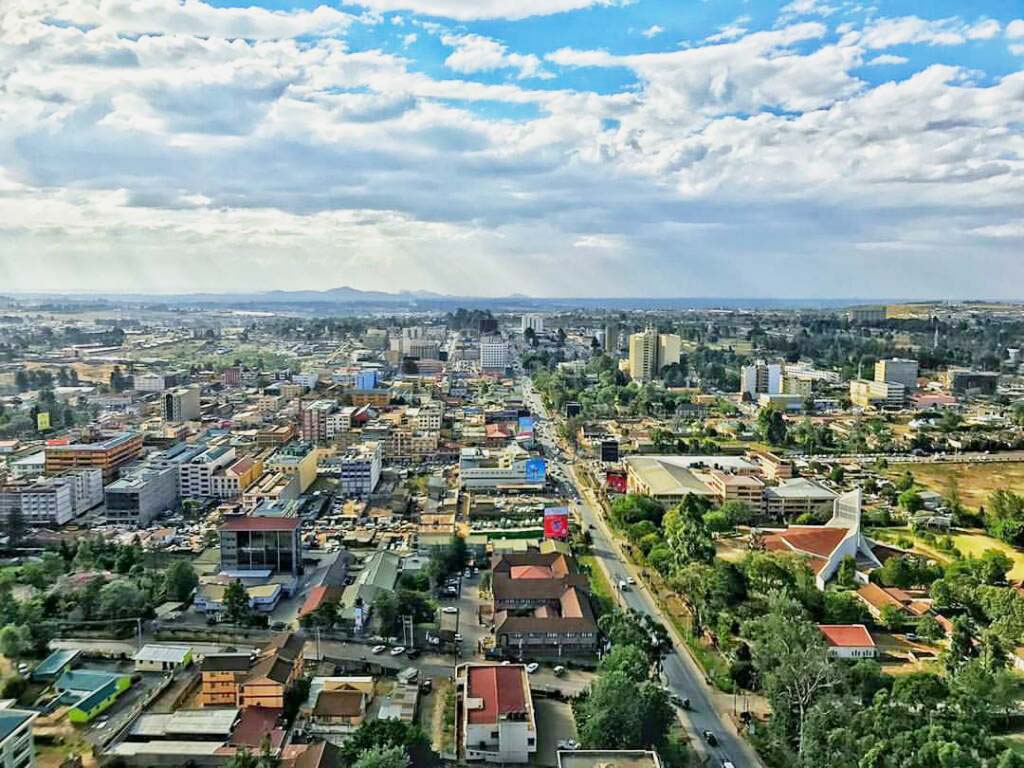
Eldoret
Before it was Eldoret, it was Sisibo. Before that, it was Farm 64 -- named for the 64 miles that separated a cluster of Afrikaner homesteads from the Londiani railhead on the Uganda Railway. The name stuck in local parlance, mutating through vernacular influence into 'Sisibo' before colonial authorities officially christened the settlement Eldoret in 1912. Today, with a population of 475,716 and city status conferred in August 2024, Eldoret is Kenya's fifth-largest urban area. But numbers alone do not capture what makes this highland city distinctive. At an elevation above 2,100 metres, surrounded by the wheat fields and dairy farms of the Uasin Gishu Plateau, Eldoret has become the epicenter of distance running -- a place where the thin air, the altitude, and a culture of competitive excellence have produced a concentration of world-class athletes that defies statistical probability.
Layers Beneath the Plateau
Long before Afrikaner settlers ploughed the Uasin Gishu Plateau, the Sirikwa people farmed and herded cattle across these highlands. Archaeologists associate them with a distinctive Late Iron Age culture spanning roughly AD 1200 to 1600, marked by circular earthwork enclosures called Sirikwa holes, irrigation channels, and tumuli concentrated in the modern counties of Trans Nzoia, Uasin Gishu, and Elgeyo Marakwet. Oral traditions among the Pokot and Nandi recall the Sirikwa sharing the plateau with other communities before their dispersal in the mid-19th century, driven by the movements of the Ateker confederacy. The Uasin Gishu Maasai occupied the plateau next, lending it their name, before being defeated by the Nandi in the late 1800s. When 58 Afrikaner families arrived in October 1908, led by Jan van Rensburg, the land had already passed through centuries of contest and transformation.
From Farm 64 to Fifth City
The Afrikaners settled around Sergoit Hill, acquired leaseholds, and began cultivating wheat, maize, and vegetables with ox-drawn ploughs. A post office was established at Sisibo in 1910. The Uganda Railway extension reached Eldoret in 1924, piped water arrived from the Sosiani River in 1928, and electricity followed in 1933. After independence, President Daniel arap Moi, born in neighboring Baringo District, channeled investment toward the town. Moi University -- Kenya's second public university -- opened in 1984, and Eldoret International Airport enhanced connectivity further. The Afrikaner community that had shaped early Eldoret gradually vanished; many families repatriated to South Africa during the independence transition and the Mau Mau era, and by 1987 only a handful remained. The town continued to grow as a trading center for large-scale grain farming, dairy, and horticulture, its economy anchored by manufacturers including Ken Knit, East Africa's first fully integrated textile company.
The Factory That Makes Champions
Eldoret's global identity is inseparable from running. The city sits at the edge of an altitude training zone that extends northeast to Iten, a small town at 2,400 metres where the IAAF High Altitude Training Centre draws elite athletes from around the world. Eliud Kipchoge, Kipchoge Keino, and Moses Kiptanui are among the luminaries with roots here. Mo Farah trained at altitude in the region before winning gold in the 5,000 and 10,000 metres at the 2012 London Olympics. The Champions Monument at the intersection of Kaptagat and Nairobi roads -- a bronze sculpture of four athletes running around a globe, one carrying an Olympic torch -- captures the city's identity in metal. At the Eldoret Arboretum, next to Kipchoge Keino Stadium, a Wall of Fame records the names of Olympians, World Champions, World Cross Country champions, and marathon greats. The runners have changed the city's economy too, investing their race winnings in real estate and small businesses throughout the town.
A Scar in the Rift Valley
Eldoret's story is not only one of triumph. Following Kenya's disputed 2007 presidential election, the city and surrounding Rift Valley became flashpoints for inter-ethnic violence. The most widely reported atrocity occurred near Burnt Forest, where a fire at a church sheltering displaced people killed dozens. The 2007-2008 post-election crisis left deep scars on the community -- displacement, loss of life, and a fracturing of trust between neighbors who had lived side by side for years. The violence did not define the city, but it became part of its history, a reminder that Kenya's ethnic and political tensions run through even its most celebrated places. Eldoret remains politically significant: it is the birthplace of William Ruto, Kenya's current president, who represented Eldoret North in Parliament before his election.
The View from Iten
Northeast of Eldoret, the road climbs to the escarpment town of Iten, where the Iten Viewpoint offers what is said to be the widest panorama of the Great Rift Valley visible from any single point in Africa. Below stretch the Kerio Valley, the Tugen Hills, Lake Kamnarok, and the Cherangani Hills -- the geological framework within which the plateau's human history has unfolded. In the Kerio Valley, paragliders chase thermal currents that have produced world-record flights. At the nearby Chepkiit Waterfalls, the Sosiani River plunges 100 metres over a granite escarpment. The name translates loosely as 'view from above,' and the site features four viewpoints popular for picnics and birdwatching. The altitude that makes these highlands beautiful is the same altitude that makes them ideal for distance running. In Eldoret, geography and human ambition are inseparable.
From the Air
Located at 0.52N, 35.28E on the Uasin Gishu Plateau. Eldoret International Airport (HKEL) sits at 6,941 ft elevation with a 3,475m asphalt runway, offering daily flights to Nairobi and international cargo service by Emirates and Etihad. The Eldoret Boma Airstrip within the city is at 7,050 ft with a 1,130m runway. From the air, the city appears as an urban area surrounded by large-scale wheat and dairy farms. The Nandi Escarpment is visible to the west, the Cherangani Hills to the north. Best viewed at 3,000-5,000 ft AGL to see the contrast between plateau farmland and the Rift Valley escarpment.