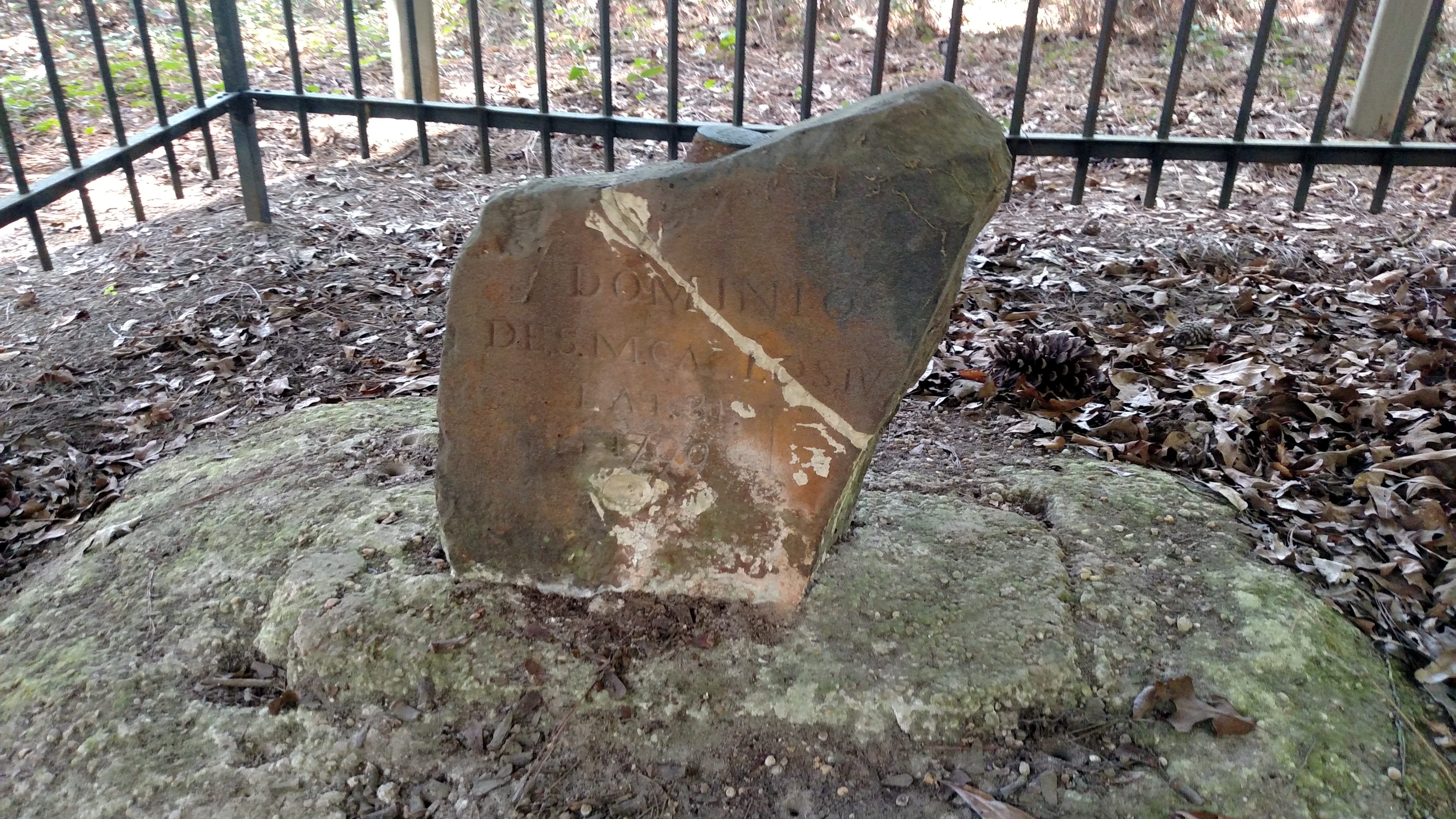
Ellicott's Stone
Read one side and you are standing in America. Read the other and you are in the dominion of King Charles IV of Spain. Ellicott's Stone sits near the west bank of the Mobile River in northern Mobile County, Alabama -- a block of ferruginous sandstone roughly two feet high and eight inches thick, inscribed on April 10, 1799, by a joint U.S.-Spanish survey party. The northern face reads 'U.S. Lat. 31, 1799.' The southern face declares 'Dominio De S.M. Carlos IV, Lat. 31, 1799.' Two nations carved their claims into opposite sides of the same rock, and that rock still stands. According to the American Society of Civil Engineers, Andrew Ellicott -- working with only the stars and rudimentary period instruments -- placed the stone within 500 feet of the true 31st parallel. That margin of error, measured by modern satellite, is an astonishing feat of 18th-century precision.
The Treaty That Drew the Line
The stone exists because of a treaty and a surveyor stubborn enough to enforce it. In 1795, the United States and the Kingdom of Spain signed the Treaty of San Lorenzo -- better known as Pinckney's Treaty -- which fixed the boundary between American territory and Spanish West Florida at the 31st parallel of northern latitude. The agreement also guaranteed American citizens free navigation of the Mississippi River through Spanish lands, a concession that opened the interior of the continent to commerce. But a line on a diplomatic document means nothing without a line on the ground. In 1796, President George Washington commissioned Andrew Ellicott, already famous for surveying the boundaries of the District of Columbia, to travel south and establish the physical border. Ellicott was paired with Spanish appointee Stephen Minor, known as 'Don Esteban,' and Irish-born surveyor Thomas Freeman. The expedition would take four grueling years.
Stars Over the Mobile River
Ellicott and his crew set out into territory that fought them at every step. They hacked through nearly impenetrable swamps, navigated hostile terrain, managed dissident laborers, and faced the threat of attacks from Native American groups whose land the border bisected without their consent. Ellicott established an observatory on a bluff above the Mobile River, where he spent nights taking celestial observations to fix the latitude. Without GPS, without electrical instruments, without anything more sophisticated than a zenith sector and a good chronometer, he calculated the position of the 31st parallel and marked it with the sandstone block that bears his name. The stone became the initial point for all United States Public Land surveys in the southern regions of Alabama and Mississippi -- a reference marker from which property lines, county boundaries, and state borders would radiate outward for generations. Ellicott later published The Journal of Andrew Ellicott in 1803, documenting the flora, fauna, people, and political tensions he encountered throughout the expedition.
Two Empires in Sandstone
The stone's dual inscription captures a moment of geopolitical tension frozen in rock. In 1799, Spain still controlled the vast territory of West Florida stretching from the Mississippi River to the Apalachicola. The United States was barely two decades old, still uncertain of its southern reach. The 31st parallel was not just a geographic line but an assertion -- that the young republic's territory extended to a specific latitude and that Spain recognized it. King Charles IV's name on the south face of the stone was the Spanish crown's acknowledgment of that boundary. Within two decades, the entire region would change hands. Spain ceded West Florida, the Adams-Onis Treaty of 1819 finalized American sovereignty, and Alabama achieved statehood the same year. The inscription on the southern face became a historical artifact almost overnight, a relic of a Spanish dominion that evaporated. Yet the stone endured, because the American side remained relevant -- the 31st parallel still defines the Alabama-Florida state line.
A Landmark Nearly Forgotten
For much of the 19th and 20th centuries, Ellicott's Stone sat in obscurity near the riverbank, overshadowed by the industrial landscape that grew up around it. Today the stone is near the James M. Barry Electric Generating Plant, west of the Mobile River -- hardly a scenic setting for a monument to Enlightenment-era science. A park was established at the site in 1917, but the location remains little visited compared to Alabama's more prominent landmarks. Recognition came slowly: the American Society of Civil Engineers designated it a Historic Civil Engineering Landmark in 1968, and it was added to the National Register of Historic Places on April 11, 1973. The stone's importance is less about what you see than what it represents -- the precise moment when two empires agreed on where one ended and the other began, measured by a man watching stars from a river bluff with instruments that fit in a wooden case. Every property deed in southern Alabama and Mississippi traces its legal origin back to this unassuming sandstone marker.
From the Air
Located at 31.998N, 88.023W on the west bank of the Mobile River in northern Mobile County, Alabama. The stone is near the James M. Barry Electric Generating Plant, which is visible from altitude as a large industrial facility along the river. Nearest airport: Mobile Regional Airport (KMOB), approximately 20nm south-southwest. From 2,000-3,000 feet AGL, follow the Mobile River north from the I-65 bridge; the generating plant and surrounding park area are on the west bank. The stone itself is not visible from the air, but the river bend and plant serve as reliable landmarks.