Enchanted Rock
After sundown, when the Hill Country air cools and the last hikers have descended, Enchanted Rock begins to speak. The massive pink granite dome groans and creaks as it contracts from the day's heat, sounds so unsettling that the Tonkawa people, who inhabited the area in the 16th century, believed ghost fires flickered at the summit. The Comanche and Apache ascribed magical and spiritual powers to the formation. Spanish explorers heard the legends and the name stuck: Enchanted Rock. The first European to visit was probably Alvar Nunez Cabeza de Vaca in 1536. Nearly five centuries later, the rock still draws people with the same pull -- something ancient, enormous, and not quite explainable rising from the rolling grasslands of Gillespie and Llano counties, north of Fredericksburg, Texas.
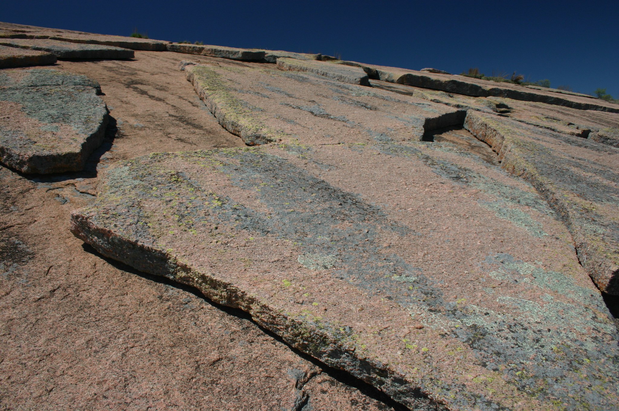
A Billion Years of Granite
What visitors see is only the tip. Enchanted Rock is the surface expression of a vast igneous batholith called the Town Mountain Granite, middle Precambrian material that intruded into older metamorphic schist -- the Packsaddle Schist -- over a billion years ago. Geologists classify the weathered dome as a monadnock: a remnant of harder rock standing above the eroded plain of the Llano Uplift. It is the largest pink granite monadnock in the United States. The dome covers roughly 640 acres and rises approximately 425 feet above the surrounding terrain to an elevation of 1,825 feet above sea level. The rock's surface exfoliates in great sheets, a process visible in the curving slabs that peel away like layers of an onion. Designated a National Natural Landmark by the National Park Service in 1971, the geological story here is measured not in centuries but in eons.
11,000 Years of Footsteps
Archaeological evidence places human presence at Enchanted Rock stretching back at least 11,000 years. Paleo-Indian projectile points dating to 11,000-12,000 years ago have been found upstream and downstream of the rock. The oldest authenticated artifact within the present-day park boundaries is a Plainview point, roughly 10,000 years old. These early hunter-gatherers used flint-tipped spears and fire, and they carried stories. The Tonkawa, Comanche, and Apache all left their mark on the rock's mythology. Native peoples used the upper tiers of the formation as a hiding place, invisible from the ground below. In 1864, German-Texan artist Hermann Lungkwitz painted the dome at least six times, captivated by its shifting colors. A monumental nine-panel mural by Thomas Evans, Hill of the Medicine Man, depicting an aerial view of Enchanted Rock, hangs above the ticketing counters at Austin-Bergstrom International Airport.
Where Fairy Shrimp Meet Dark Skies
The rock's ecosystem is a study in resilience. More than 500 plant species from four distinct communities -- open oak woodland, mesquite grassland, floodplain, and granite rock community -- inhabit the park. Vernal pools that form in depressions on the granite surface harbor fragile fairy shrimp, invertebrates that exist in these temporary puddles and nowhere else nearby. White-tailed deer, ringtail cats, nine-banded armadillos, and the Texas horned lizard share the landscape. Birdwatchers come for the painted buntings, vermilion flycatchers, scissor-tailed flycatchers, and canyon wrens. Enchanted Rock is also a certified International Dark Sky Park. On new moon nights, the park achieves Bortle 3 darkness: the Milky Way stretches in full luminous detail, meteors streak freely, and the naked eye can resolve more than 6,000 stars. Star parties and nighttime events draw astronomers from across Texas.
A Park Nearly Tripled
Enchanted Rock State Natural Area drew 307,686 visitors in 2022 and was rated the best campsite in Texas in a 2017 fifty-state survey. The popularity created pressure. In August 2024, the Texas Parks and Wildlife Department approved the purchase of 630 acres adjacent to the park, expanding its size by almost 40 percent. Then, in January 2025, an additional 3,073 acres of adjacent land was acquired, nearly tripling the park's total acreage. Funding came from the $1 billion Centennial Parks Conservation Fund, created during the 88th Texas Legislature in 2023. A quieter expansion had already occurred in May 2022, when 41 acres were added to the south. The Granite Gripper, an annual rock climbing competition, serves as a fundraiser for park conservation through the Friends of Enchanted Rock. Pets are not allowed on the Summit Trail, the most popular hiking path, and visitors are asked to leave plants, animals, and artifacts undisturbed.
The Rock That Groans
The legends persist. A Native American princess is said to haunt the summit after throwing herself from the rock in grief. Footprint indentations mark a chief condemned to walk the dome forever. A white woman's screams echo from the night she took refuge on the rock after escaping captivity. The plaque that once stood near the summit, now displayed in a kiosk below, recounts these stories alongside the tale of a Spanish soldier named Don Jesus Navarro who rescued a native maiden from Comanche captors on the rock's slopes. Geologists have their own explanation for the nighttime sounds: thermal contraction of sun-heated granite. But standing on the summit at dusk, watching the Hill Country darken while the rock shifts beneath your feet, the scientific explanation feels thin. The Tonkawa called what they heard ghost fires. After 11,000 years of human visitors, Enchanted Rock still has not run out of stories to tell.
From the Air
Located at 30.507N, 98.819W in the Texas Hill Country, straddling the Gillespie-Llano county line. The massive pink granite dome rises to 1,825 feet MSL and is unmistakable from altitude -- a pale, bald dome surrounded by dark oak-covered hills in the Llano Uplift basin. Gillespie County Airport (T82) at Fredericksburg is approximately 18 miles south. Llano Municipal Airport (AQO) lies about 18 miles northeast. The dome is visible from considerable distance at cruise altitude. Best viewed at 3,000-5,000 feet AGL approaching from the south along Ranch Road 965. Austin-Bergstrom International (KAUS) is roughly 85 miles east-southeast.