Enggano Island
Its name means "mistake" in Portuguese, though nobody recorded which mistake, exactly, the Portuguese sailors had in mind. Perhaps they expected mainland Sumatra and found instead this low, forested island sitting alone in the Indian Ocean, 114 kilometers off the southwest coast. Enggano Island has been confounding arrivals ever since. When the Dutch navigator Cornelis de Houtman sailed past on June 5, 1596, he could not even manage to land a boat. Nearly two centuries later, the Englishman Charles Miller succeeded in going ashore, only to be rushed by armed warriors in canoes. The island that rebuffed outsiders for centuries now faces a quieter kind of transformation, as immigrants from Java and Sumatra steadily outnumber the indigenous Engganese people whose ancestors once had the place entirely to themselves.
A Low Island in Open Water
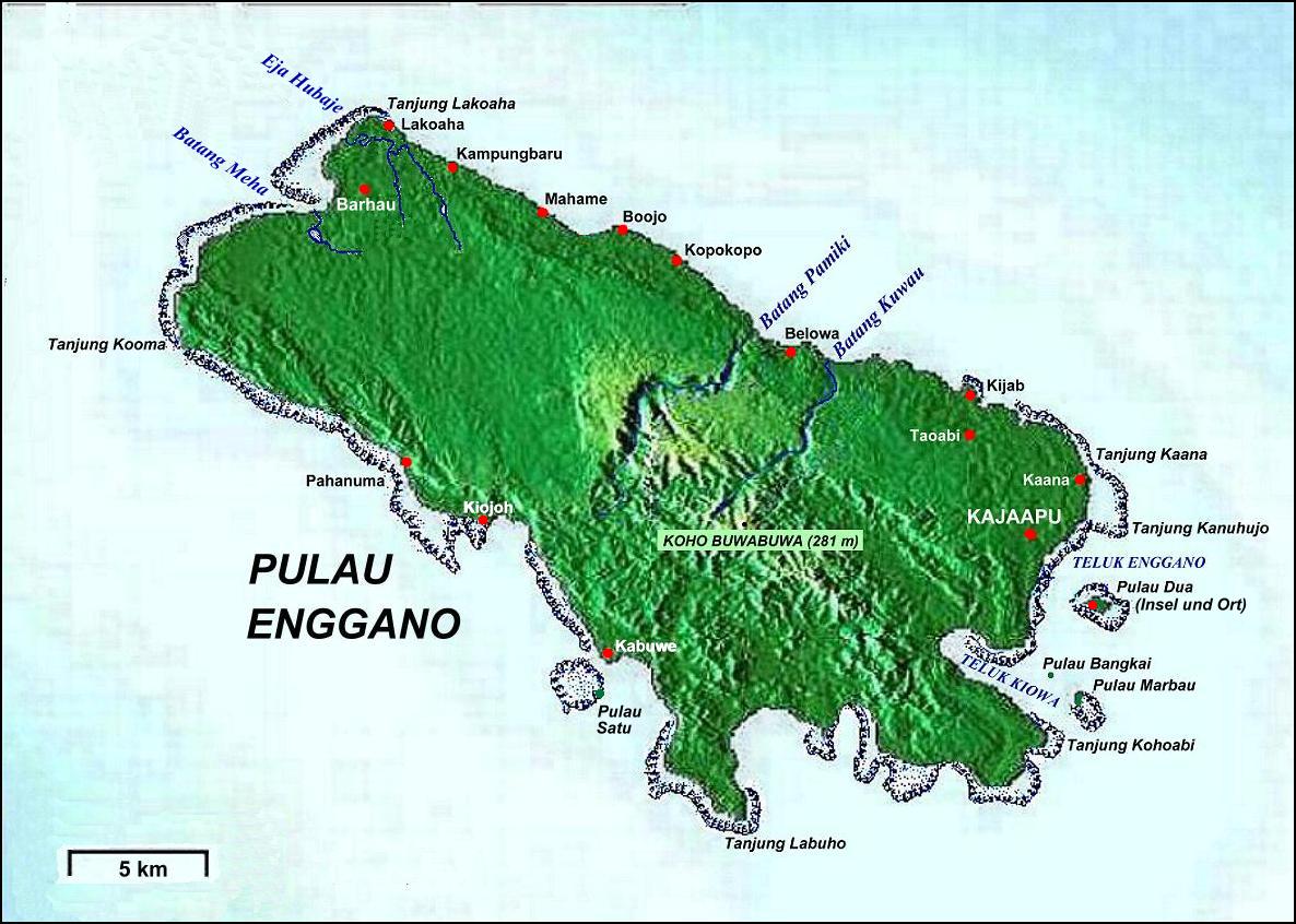
Enggano stretches roughly 29 kilometers from east to west and 14 kilometers north to south, covering about 400 square kilometers. It rises gently from the ocean, never exceeding 281 meters at its highest point, with an average elevation of around 100 meters. Four small satellite islands cluster around its coast: Pulau Merbau, Pulau Dua, and tiny Pulau Banggai off the east side, and Pulau Satu to the south. The island qualifies as one of Indonesia's 92 officially listed outlying islands, a designation that speaks to its geographic isolation. Six villages line a single main road tracing the northeast coast: Kayaapu, Kaana, Malakoni, Apoho, Meok, and Banjarsari. Ferries connect Kahayapu and Malakoni to the city of Bengkulu on the Sumatran mainland, but the crossing is long enough to keep casual visitors away.
The Shore That Fought Back
Charles Miller's 1771 account of attempting to land on Enggano reads like an adventure novel. After beating along the southwest coast without finding a safe anchorage, losing two anchors, and nearly wrecking his vessel, he discovered a harbor at the southeast end. When his small boat rounded the point of an offshore island, he found the beach "covered with naked savages" armed with lances and clubs, while twelve canoes full of warriors rushed out from concealment. With only one European, four Black soldiers, and four lascars rowing, Miller turned for the cover of his ship's guns. Eventually, he did make contact, and his observations revealed a matriarchal society that, by his account, practiced no religion the Europeans recognized. The encounter marked one of the earliest documented meetings between the Engganese and the outside world, a world that would not treat them kindly in the centuries to come.
A People in Decline
Beginning in the 1870s, the Engganese population went into severe decline, likely from diseases introduced through increasing outside contact. The Dutch colonial government sent medical officers to investigate, but the trajectory was grim. Then came 1883. When Krakatoa erupted with catastrophic force, the resulting tsunami swept across the Indian Ocean. Enggano, low-lying and unprotected, with no point higher than 281 meters, would have been devastated by both the wave and the massive volcanic debris that followed. The indigenous population never recovered. By the early 1960s, only about 400 Engganese people remained. Immigration from Java and Sumatra has since reshaped the island's demographics: the 2020 census counted 4,035 inhabitants, but the original Engganese are now substantially outnumbered by newcomers. As recently as 1994, 64 percent of the island's 1,635 residents still claimed Engganese descent. That proportion has been falling ever since.
A Language Like No Other
Linguists remain unsettled about where Enggano's indigenous language belongs. The Enggano language, also called Engganese, may be a member of the Austronesian family, specifically the Malayo-Polynesian branch, but if so, it is a deeply divergent one, sharing little recognizable vocabulary with its supposed relatives. The alternative hypothesis is more dramatic: that Enggano is a language isolate, a tongue with no confirmed relatives anywhere, that has simply absorbed some Austronesian vocabulary through contact over the centuries. Either answer is remarkable. If Austronesian, the language's extreme divergence suggests the Engganese arrived on the island very early and then lived in near-total isolation for millennia. If a true isolate, it represents a linguistic lineage that survived when all its neighbors were absorbed or replaced by the Austronesian expansion.
An Island of Endemics
Enggano's isolation has produced more than a unique language. The island harbors a suite of endemic species found nowhere else on Earth. Five bird species carry the island's name: the Enggano scops owl, the Enggano imperial pigeon, the Enggano thrush, the Enggano hill myna, and the Enggano white-eye. BirdLife International has designated Enggano an Important Bird Area in recognition of this avian distinctiveness. The forests that sustain these species are under pressure from immigration and development, though a 2011 environmental impact study focused on surveying avian populations hinted at growing awareness of what could be lost. For now, the island remains what it has always been: a place apart, separated from the Sumatran mainland by enough open water to develop its own species, its own language, and its own way of life.
From the Air
Located at 5.39S, 102.24E in the Indian Ocean, approximately 114 km southwest of the Sumatran coast. The island is clearly visible as a distinct, low-lying landmass surrounded by deep blue ocean. Fatmawati Soekarno Airport (WIPL) at Bengkulu on the Sumatran mainland is the nearest significant airfield, roughly 115 km to the northeast. A small airstrip exists on Enggano itself. Best viewed at 5,000-10,000 ft AGL, where the island's elongated east-west shape and its four small satellite islands are visible. The open water between Enggano and Sumatra is striking from altitude.