Enon Formation
When Gondwana broke apart, it left debris. The Enon Formation is that debris made permanent: coarse, poorly sorted conglomerate deposits scattered in patches across the Eastern and Western Cape provinces of South Africa, recording a period of violent erosion as the Cape Fold Belt mountains crumbled during the supercontinent's disintegration. Dating from the Late Jurassic to Early Cretaceous, roughly 160 to 100 million years ago, these reddish rocks are the oldest onshore post-Karoo Mesozoic deposits in South Africa, a geological ground floor for everything that came after.
A Supercontinent Leaves Its Calling Card
The Enon Formation formed along South Africa's southern coast as Gondwana rifted apart and the Cape Fold Belt underwent massive erosion. Rivers carried the debris of collapsing mountains southward, depositing thick beds of cobbles and pebbles in the basins that opened between separating landmasses. The result is a distinctive rock: thickly-bedded conglomerate with clasts of pale or white quartzite set in a gypsiferous sandy clay matrix, often stained reddish by iron oxide. In its type locality, the Algoa Basin near Port Elizabeth, the formation reaches a maximum thickness of 480 metres. Additional outcrops, once continuous but now fragmented by subsequent erosion, appear in the Worcester-Pletmos and Oudtshoorn-Gamtoos Basins, as well as in several smaller isolated basins near Bredasdorp. The formation is the lowermost of four units within the Uitenhage Group, underlying the softer Kirkwood and Sundays River Formations.
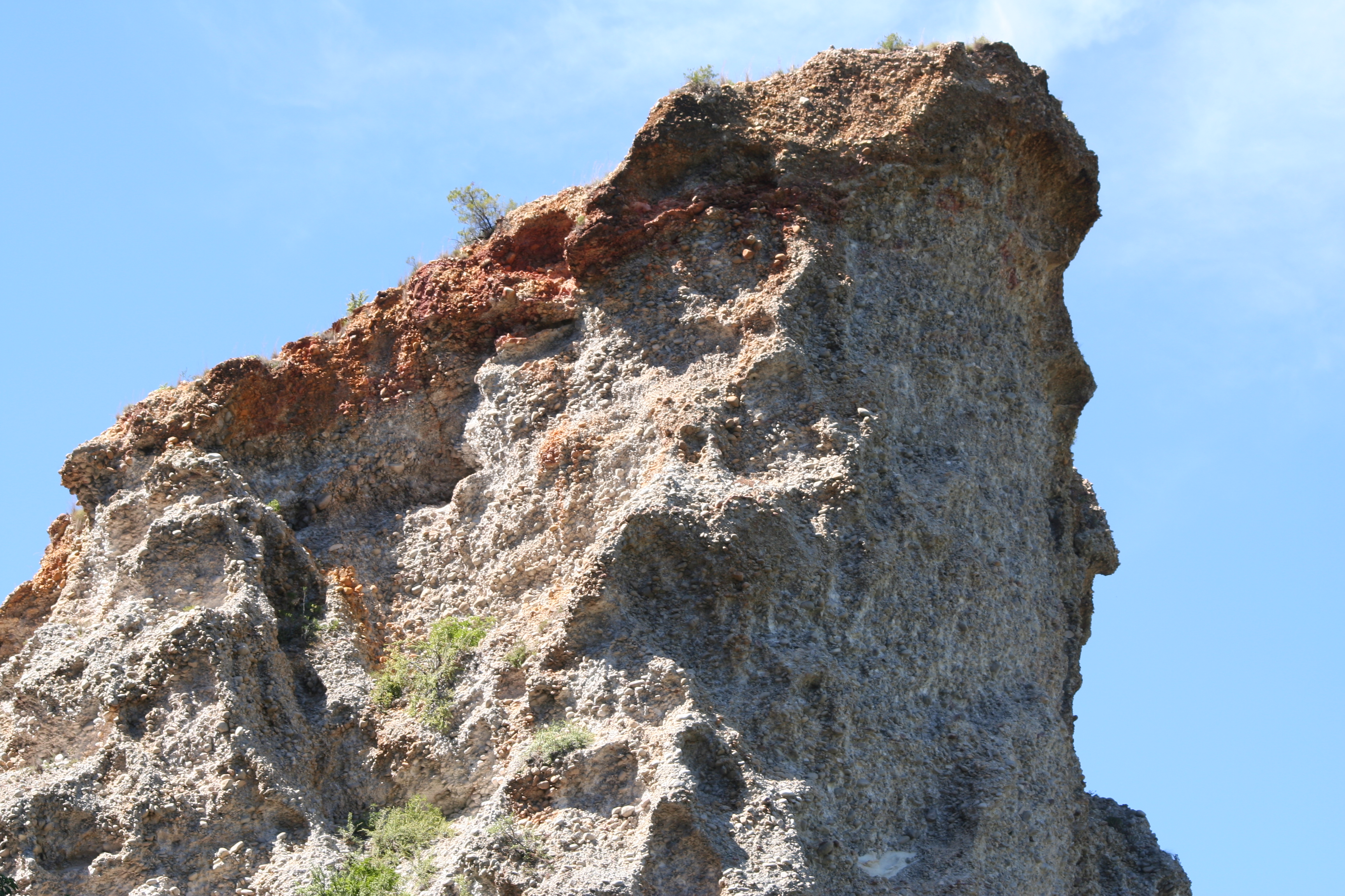
Reading the Rocks
Each outcrop of the Enon Formation tells a slightly different story about its source material. At Worcester, the clasts are partially-rounded grit and Witteberg sandstone cemented in reddish argillaceous sandstone. Near Ashton, clasts of Dwyka tillite and fine greenish shale pebbles appear alongside the sandstone. At Swellendam, Bokkeveld shale and micaceous Witteberg sandstone clasts sit in a reddish-green sandy clay matrix. The variation reflects local geology: each outcrop preserves debris eroded from whatever mountains stood nearby during the Mesozoic. At some sites, water-sorted clasts of similar size occur in neat layers separated by sandstone lenses, evidence of organized river deposition. Elsewhere, clasts of wildly different sizes are jumbled together with sandy matrix, suggesting more chaotic deposition from flash floods or debris flows. Much of the formation tends toward smaller clasts in an iron-rich matrix, giving the rock its characteristic reddish colour.
A Map of Fragments
Though the Enon Formation was once continuous, it now survives as a patchwork of outcrops scattered across the southern Cape. Along the Worcester-Pletmos Basin, remnants cling to the southern flanks of the Langeberg Mountains from Worcester to Mossel Bay. In the Breede River valley, the beds are tilted southward and occur in three main outcrops. South of the Swartberg range, outcrops dot the landscape around Oudtshoorn and extend eastward through the Oudtshoorn-Gamtoos Basin. A large but heavily eroded patch survives in the Soutpansvlakte Basin northeast of Bredasdorp. Smaller, isolated outcrops appear at Jubilee and Haasvlakte, where pale red and grey conglomerates support occasional silcrete caps. At the Oudtshoorn theropod site, dinosaur remains have been recovered from the Enon Formation, though fossil preservation in the coarse conglomerate is extremely poor.
Gondwana's Ghost in the Karoo
The Enon Formation matters to geologists because it captures a specific moment in Earth's history: the transition from the stable supercontinent era to the fragmented world of separate continents. The rocks record the erosion of the Cape Fold Belt during Gondwana's breakup, providing data on how the landscape changed as tectonic forces tore southern Gondwana apart. The Kirkwood Formation's softer sandstones and mudstones, which overlie the Enon, record the quieter period that followed, when rivers replaced torrents and fine sediments replaced rubble. At their lateral boundaries, the Enon's conglomerate beds often interfinger or transition gradually into these softer deposits, a geological record of a violent era giving way to calmer conditions. The formation's unconformities, where it meets older Cape Fold Belt rocks below, mark gaps in the geological record where millions of years of history are simply missing, eroded away or never deposited.
From the Air
Coordinates: 33.60S, 22.20E. Enon Formation outcrops are scattered across the southern Cape between Worcester (roughly 33.7S, 19.4E) and Port Elizabeth (roughly 33.8S, 25.6E). The formation is not a single visible feature but appears as reddish rock exposures along valley flanks and road cuttings, particularly south of the Swartberg range near Oudtshoorn. Nearest airports: George Airport (FAGG) approximately 60 km south; Oudtshoorn Airfield nearby. Cape Town International (FACT) approximately 430 km west.