Erhai Lake
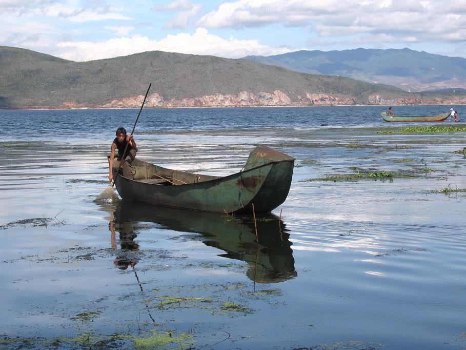
On Erhai Lake, a Bai fisherman stands in a narrow wooden boat and loosens the ring around his cormorant's throat. The bird plunges, surfaces with a fish too large to swallow past the ring, and delivers it to the man's waiting hand. This partnership between human and bird has played out on these waters for generations, one of the most ancient fishing techniques still practiced anywhere. Erhai itself sits at 1,972 meters above sea level in Yunnan province, 40 kilometers long and 7 kilometers wide, sandwiched between the soaring Cang Mountains to the west and the rooftops of Dali to the east. Its name has wandered through centuries of linguistic evolution, from the Bai word for "lower water" through a series of Chinese character substitutions to the modern name that has stuck.
A Lake Between Kingdoms
Erhai has been central to the civilizations that rose and fell along its shores. During the Tang dynasty, the Nanzhao Kingdom used the lake as a royal deer ranch, an expanse of water so valued that it served dual purposes as both food source and aristocratic preserve. The lake was known in ancient times as Yeyuze and Kunming Lake, the latter name deriving from the Kunming Yi, an ethnic group that inhabited the surrounding region from the Han dynasty through the Tang. The Bai people, who remain the dominant culture around Dali today, have built their identity around the lake for centuries. With a circumference of 116 kilometers and an average depth of 11 meters, Erhai holds a total storage capacity of 2.5 billion cubic meters, making it the second-largest highland lake in China after Dianchi Lake.
The Geography of a Sandwich
Dali Town occupies one of the more dramatic settings in China: pressed between the Cang Mountains rising sharply to the west and Erhai Lake stretching to the east, the city exists in a narrow corridor where mountain meets water. The lake receives its water from the Miju and Mici Rivers flowing in from the north, the Bolou River entering from the east, and countless smaller streams cascading down from the Cang peaks. Its outlet, the Yangbi River, drains south and eventually joins the Lancang, which becomes the Mekong. From the lake's northern tip at Shangguan Town to its southern point at Xiaguan, the entire 40-kilometer span is framed by this mountain-lake geometry that has shaped settlement patterns, agriculture, and trade routes for millennia.
Vanishing Fish
Erhai once harbored extraordinary aquatic biodiversity. Of 23 fish species and subspecies recorded in the lake, 8 were found nowhere else on earth. The roster of endemics reads like a quiet roll call of loss: Cyprinus daliensis, Cyprinus megalophthalmus, Paracobitis erhaiensis, and others, species that evolved in this single body of water over thousands of years. Of the eight endemics, only two, Cyprinus barbatus and Cyprinus longipectoralis, have been recorded since the year 2000. The remaining six have not been seen in decades and are likely extinct. Meanwhile, more than 10 introduced fish species now inhabit the lake, occupying niches that once belonged to creatures found nowhere else. Native water plants have also disappeared. Erhai is one of three major Yunnan lakes recognized for high endemism, alongside Fuxian Lake and Dianchi, but that distinction increasingly commemorates what was rather than what is.
Islands and Butterfly Springs
Scattered across Erhai's surface are islands that have drawn visitors for centuries. Guanyin Ge, Jinsuo Island, Nanzhao Folklore Island, and tiny Xiaoputuo Island each offer a different perspective on the lake and its cultural layers. On the western bank, Butterfly Springs draws its name from the seasonal congregations of butterflies that once gathered there in vast numbers. Erhai Park provides a shoreline vantage point where the full scale of the lake-and-mountain panorama becomes apparent. The 116-kilometer shoreline can be explored on foot, a circuit that takes hikers through farming villages, past temple complexes, and along stretches of undeveloped lakeshore where the Cang Mountains dominate the western sky. For the Bai people, these are not scenic attractions but the fabric of daily life, the landscape that defines home.
From the Air
Located at 25.76N, 100.19E in Dali Prefecture, Yunnan province, China. The lake is a prominent visual feature: 40 km long and 7 km wide, oriented north-south, at an elevation of 1,972 meters. The Cang Mountains (peaks to approximately 4,122 meters) rise immediately to the west. Dali Airport (DLU) lies near the southern end of the lake at Xiaguan. Lijiang Sanyi International Airport (LJG) is approximately 150 km to the north. The lake's elongated shape and the adjacent mountain range make it unmistakable from cruising altitude in clear conditions.