Eshowe
Four Zulu kings called this place home. Shaka, the military genius who forged the Zulu nation. Mpande, who ruled the longest. Cetshwayo, who led his people into the war that would define British-Zulu relations forever. And Dinizulu, who inherited a kingdom already in decline. Eshowe's connection to Zulu royalty runs deeper than any colonial fort or mission station, though it has those too. Set on an elevation in the rolling green hills of KwaZulu-Natal, this small town of 15,000 people is wrapped in the Dlinza Forest, one of only five remaining coastal scarp forests in the province. Mist gathers in the canopy during the wet season, and the town claims to have one of the highest rainfalls in South Africa. It has won the country's most picturesque town award, and a drive through its suburbs explains why.
The Siege on the Hill
In January 1879, Colonel Charles Pearson led a British column across the Tugela River and into Zululand. His objective was a disused Norwegian mission station on a hill near Eshowe, which he intended to fortify as an advance base. The Reverend Hans Schroeder of the Norwegian Mission Society had established the station in 1861, with King Mpande's permission, but war had emptied it. Pearson occupied the site and began building defenses. Then the Zulu army cut his supply lines. For roughly ten weeks, over 1,300 British troops and their native auxiliaries held out under siege, battling not just the Zulu forces surrounding them but disease, dwindling rations, and the humid KwaZulu-Natal climate. On 3 April, a relief column of nearly 5,700 men under Lord Chelmsford broke through. The siege was lifted, but the mission station was eventually razed. Today, little remains of the fort near the town of Gezinsila, a reminder that the land has its own way of reclaiming what armies leave behind.
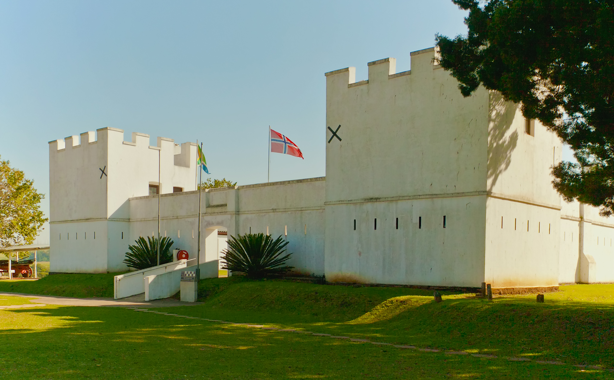
Fort Nongqayi and the Architecture of Control
The British built Fort Nongqayi in 1883, four years after the Anglo-Zulu War ended. The fort served as barracks for the Nongqayi, a native police force recruited from Zulu ranks to maintain order in the newly conquered territory. Eshowe became the administrative headquarters of Zululand, a role that required imposing buildings and the appearance of permanence. The fort's thick walls and defensive layout speak to a period when the British were consolidating control over a people who had very nearly defeated them. Today, Fort Nongqayi houses the Zululand Historical Museum and the Vukani Zulu Cultural Museum, where traditional beadwork, carvings, and artifacts document a culture that colonialism could administer but never erase. The fort complex also includes a small chapel and community projects, a transformation from military installation to cultural repository that mirrors the broader trajectory of post-apartheid South Africa.
A Forest Inside a Town
The Dlinza Forest does not surround Eshowe; it runs through it. This 250-hectare tract of indigenous coastal scarp forest is enmeshed with the town's fabric, its canopy pressing against suburban boundaries. An aerial boardwalk lifts visitors into the treetops, where rare bird species move through the branches and the endangered Spotted Ground Thrush forages in the leaf litter below. Blue duiker, bushpig, and several species of monkey inhabit the forest floor. Butterflies drift between shafts of light that penetrate the canopy. For a town built on a history of warfare and colonial administration, the forest offers something different entirely: silence, shade, and the smell of damp earth. KwaZulu-Natal once had extensive coastal scarp forests, but development and agriculture have reduced them to a handful of remnants. That one of the largest survivors wraps itself around a town center, rather than existing in some distant reserve, makes Eshowe's relationship with its forest unusually intimate.
The Green Hills Beyond
Eshowe's elevation sets it apart from the coastal lowlands. Cooler than Durban in summer and often shrouded in mist during the rains, it feels more like a highland retreat than a subtropical town. The surrounding countryside rolls with sugar cane fields and traditional Zulu homesteads, a landscape where round thatched huts still dot the hillsides alongside modern houses. The nearby Shakaland cultural village offers visitors a curated experience of Zulu life, built on the site where the television series 'Shaka Zulu' was filmed in the 1980s. Beyond the cultural attractions, the region serves as a gateway to some of KwaZulu-Natal's great wilderness areas: the iSimangaliso Wetland Park to the north, the Hluhluwe-Umfolozi Park with its critical rhino populations, and 42 kilometers of unspoiled coastline in the Siyaya Coastal Park. Eshowe sits at the junction of culture and nature, history and wildness, in a province that has more of all four than most.
From the Air
Coordinates: 28.89S, 31.45E. Eshowe sits on elevated terrain inland from the KwaZulu-Natal coast, roughly 150 km northeast of Durban. The Dlinza Forest is visible from the air as a dark green patch surrounding the town center. The town is accessed from the N2 via Route 66. The terrain is hilly with sugar cane fields and indigenous forest patches. In the wet season, low cloud and mist are common, reducing visibility. Nearest major airport: King Shaka International (FALE, Durban), approximately 130 km south. Richards Bay Airport (FARB) is closer at approximately 80 km northeast. Recommended viewing altitude: 3,000-5,000 ft AGL, weather permitting.