A Century Behind the Gate
For roughly a century, no one walked this coastline who did not work the ranch. The Bottarini family and their successors ran cattle across 547 acres of rolling grassland and coastal bluff overlooking the mouth of the Estero Americano, a tidal estuary where Sonoma and Marin Counties meet. The Pacific crashed against the cliffs below, migrating birds swept along the flyway overhead, and the public drove past on Highway 1 without ever setting foot on the property. Then, in 2015, The Wildlands Conservancy purchased the ranch for $3.8 million. A decade of trail building, habitat restoration, and permitting followed. When the preserve finally opened in late 2025, visitors discovered a landscape that had been hiding in plain sight - wildflower-covered bluffs dropping to an undeveloped beach, panoramic views stretching from Bodega Head to Point Reyes, and an estuary teeming with life.
Where Salt Meets Fresh
The Estero Americano - Spanish for American Estuary - is a narrow tidal inlet that snakes inland from the Pacific for several miles, its mouth opening and closing with the seasons. In winter, storm waves can breach the sandbar and flood the lower estuary with saltwater. In summer, the bar builds back up and the estuary calms into a brackish lagoon. This dynamic mixing of salt and fresh water creates an unusually productive ecosystem. Tidal marshes, eelgrass beds, and mudflats line the estuary's edges, providing nursery habitat for fish and forage for shorebirds. The estuary falls within the Greater Farallones National Marine Sanctuary, one of the most biologically productive marine regions on the entire West Coast - a designation that reflects not just the ocean beyond but the critical estuarine habitat where land and sea negotiate their boundary.
The Smallest Residents
Three federally listed species anchor the preserve's conservation significance. Central California Coast steelhead run the estuary's channels, following ancient routes between ocean and freshwater spawning grounds. The tidewater goby, a tiny fish rarely longer than two inches, inhabits the brackish shallows - so specialized in its habitat requirements that it serves as an indicator species for the health of coastal lagoons up and down California. And the California red-legged frog, the largest native frog in the western United States and the species Mark Twain immortalized in his jumping frog tale, breeds in the wetlands that fringe the estuary. These three species, each threatened by habitat loss elsewhere along the coast, find refuge in the Estero Americano's relatively undisturbed waters. The ranch's long closure to the public may have been its greatest gift to them.
Prairie in Bloom
Above the estuary, the preserve's uplands are coastal prairie - a grassland ecosystem that once covered much of California's coast but has been largely lost to development and invasive species. In spring, the bluffs erupt with wildflowers: iris, blackberry blossoms, and lupine spreading across the rolling terrain in a display that draws hikers and photographers alike. Badgers dig their burrows in the open grassland. Bobcats hunt the edges where prairie meets scrub. Hawks and kestrels ride the thermals that rise off the sun-warmed bluffs, scanning for ground squirrels below. The preserve sits along the Pacific Flyway, one of the four major migratory bird routes in the Americas, and during spring and fall migration the skies above the estuary fill with ducks, geese, and shorebirds pausing to rest and feed before continuing their journeys.
From Ranch to Refuge
The purchase of Bottarini Ranch required a coalition that reflected how complicated conservation has become in coastal California. The Wildlands Conservancy led the acquisition, but funding came from the California State Coastal Conservancy, the Gordon and Betty Moore Foundation, the Sonoma County Agricultural Preservation and Open Space District, the Sonoma Land Trust, and individual donors. The $3.8 million price tag was only the beginning. Trail construction, signage, restroom facilities, kayak access points, and the renovation of an old ranch house for a caretaker all required additional investment. In September 2025, the Coastal Conservancy awarded another $240,200 for public access improvements. Grazing continues on the property as a rangeland management tool, keeping invasive grasses in check and maintaining the open character of the coastal prairie.
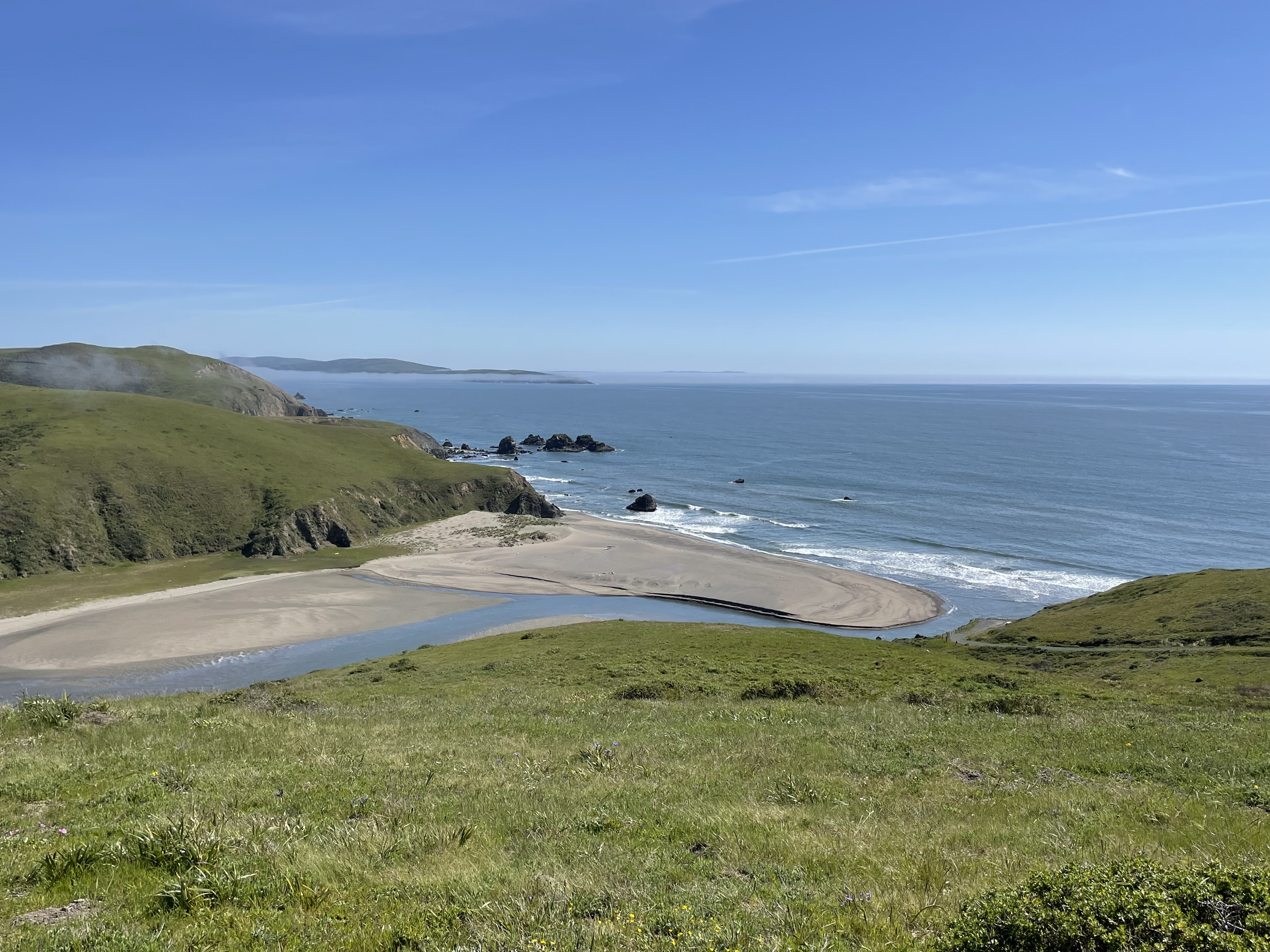
Five Miles to the Edge
The preserve now offers roughly five miles of hiking trails that connect the blufftop terraces to the estuary shoreline and the beach at the estuary's mouth. The trail system links a long-established coastal access corridor to a new network of interior paths, creating a loop that takes walkers from high grassland views down to tidal mud and back. On clear days, the panorama from the upper bluffs takes in Bodega Bay and Bodega Head to the north, the Pacific horizon to the west, and the distant silhouette of Point Reyes to the south. A kayak pull-out allows paddlers to explore the estuary from the water. The beach at the mouth is broad and undeveloped - no lifeguards, no concessions, no parking lot nearby. Portions may be inaccessible during winter breaching events, but for most of the year it remains one of the quietest stretches of sand on the Sonoma coast.
From the Air
Located at 38.30N, 123.01W on the Sonoma coast where Sonoma and Marin Counties meet. The preserve is visible from the air as a section of coastal bluff and rolling grassland at the mouth of the Estero Americano, a narrow tidal estuary running inland from the Pacific. Look for the estuary mouth where a sandbar separates the inlet from the ocean - the bar opens and closes seasonally. Bodega Bay and Bodega Head are visible to the north; Point Reyes peninsula to the south. The coastline here is rugged with steep bluffs dropping to rocky shore and scattered pocket beaches. Nearest airport: Sonoma County Airport (KSTS) approximately 25 nm east. Recommended viewing altitude: 2,000-3,000 feet AGL for coastline detail. Coastal fog is common, especially in summer mornings.