Estevan Point Lighthouse
On the evening of June 20, 1942, the crew at Estevan Point Lighthouse watched something surface in the water offshore. Moments later, shells began falling around the station -- 25 to 30 rounds from the deck gun of Japanese submarine I-26. Every one of them missed. The lighthouse, a tall octagonal concrete tower on the remote west coast of Vancouver Island, survived without a scratch. But the attack marked the first time enemy fire had struck Canadian soil since the Fenian raids of 1866 and 1871, and it sent a shockwave through a nation that had considered its Pacific coast safely beyond the reach of war.
Punta San Esteban
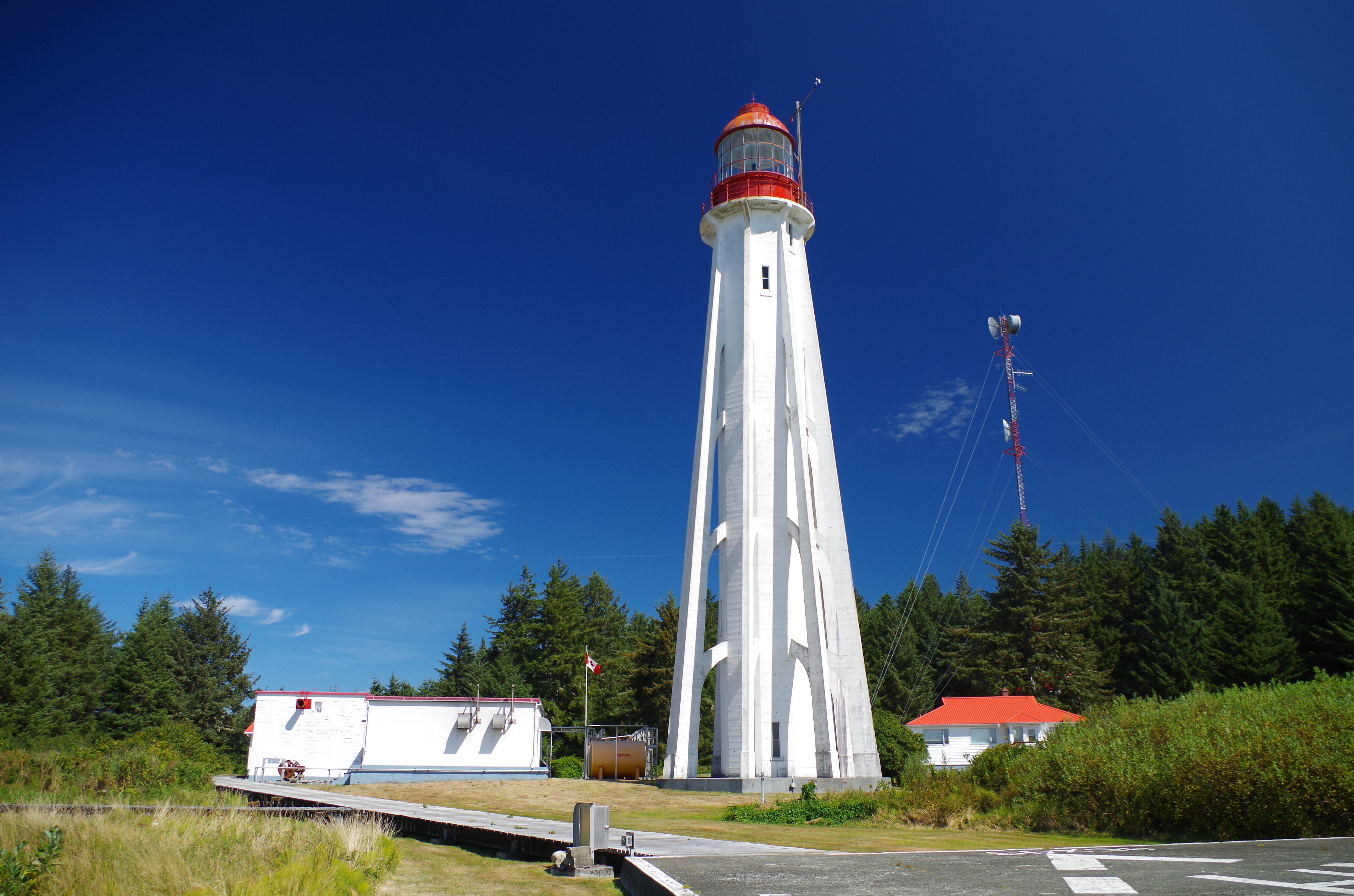
Europeans first named this headland in 1774, when Spanish explorer Juan Jose Perez Hernandez -- a native of Mallorca -- sailed along Vancouver Island's west coast and traded with the Nuu-chah-nulth people living in the region. He called the point Punta San Esteban. Four years later, James Cook's expedition arrived at nearby Nootka Sound, establishing a British presence that would eventually eclipse Spain's. The headland kept its Spanish name through the centuries, even as the world around it changed. The lighthouse was established in 1909, one in a series of buttressed concrete towers designed by engineer William P. Anderson. Its octagonal form, supported by flying buttresses, gave it a distinctive silhouette against the Pacific horizon. A first-order Fresnel lens manufactured by Chance Brothers of England focused the beam, guiding mariners along one of the most treacherous stretches of the British Columbia coast.
Thirty Shells and a Mystery
I-26 was one of several Japanese submarines prowling the Pacific coast in the summer of 1942. While I-26 shelled Estevan Point, another submarine attacked Fort Stevens at the mouth of the Columbia River in Oregon. The coordinated strikes were designed to spread fear along the western seaboard, and in that they succeeded, even though both attacks caused negligible damage. At Estevan Point, every shell either overshot or fell short. Five Royal Canadian Navy patrol vessels and a Supermarine Stranraer flying boat from the Royal Canadian Air Force scrambled to find I-26, but the submarine fled north and eventually returned to Japan without being located. One 5.5-inch shell was recovered by a naval shore patrol after the attack; additional fragments turned up as late as 1973. The mystery deepened in 1995, when a CBC Television episode of The Fifth Estate reported contradictions in eyewitness accounts and speculated the attack might have been a false flag operation by Allied vessels, intended to bolster support for Prime Minister Mackenzie King's conscription policies.
Concrete Against the Pacific
Anderson's design has proven remarkably durable. The concrete buttresses that seemed like architectural ambition in 1909 turned out to be practical engineering: they have withstood over a century of Pacific storms, salt spray, and the occasional earthquake. The original Fresnel lens and lantern were dismantled during the 1980s and donated to a regional museum in 2004, but the tower itself continues to serve. The Canadian Coast Guard still maintains Estevan Point as an active light, its light visible to vessels navigating the exposed waters off the Hesquiat Peninsula. The lighthouse sits within Hesquiat Peninsula Provincial Park, accessible only by boat or floatplane -- a remoteness that has protected it from development and preserved the wild character of the headland that Perez Hernandez first sighted over 250 years ago.
Where War Reached the Rainforest
Estevan Point occupies an unusual place in Canadian memory: a site where the vastness of the Pacific suddenly shrank, where a war fought across oceans materialized on a headland surrounded by temperate rainforest. The lighthouse keeper and radio-direction-finding station operators who huddled during the shelling experienced something no Canadian civilian had faced in over seventy years -- direct enemy fire on home soil. The oceanic climate here is mild and wet, with November bringing the heaviest rain and August the warmest temperatures. It is a landscape of mist and endurance, where the concrete tower rises above the fog line like a monument to the idea that some lights, no matter what falls around them, do not go out.
From the Air
Estevan Point Lighthouse is located at 49.38N, 126.54W on the western tip of the Hesquiat Peninsula, west coast of Vancouver Island. The lighthouse is a prominent visual landmark from the air -- a white concrete octagonal tower on an exposed headland. The nearest airport is Tofino/Long Beach Airport (CYAZ), approximately 60 km southeast. Hot Springs Cove and Hesquiat Peninsula Provincial Park surround the area. Expect frequent low cloud and marine fog along this stretch of coast.