Evergreen Point Floating Bridge (1963)
Thirty-five cents. That was the price of crossing Lake Washington when the Evergreen Point Floating Bridge opened on August 28, 1963, connecting the Montlake neighborhood of Seattle to the small town of Medina on the Eastside. The toll seemed modest, but the bridge's effect was seismic. Redmond's population leapt from fewer than 1,500 people in 1960 to 11,000 by 1970. Bellevue and Kirkland grew in tandem. A body of water that had separated Seattle from its eastern neighbors since the city's founding suddenly became a commute instead of a barrier. For more than half a century, the bridge's 7,578-foot floating section was the longest in the world -- a distinction it held until its own replacement surpassed it by 130 feet in April 2016.
Concrete on Water
The concept of a floating bridge sounds precarious, and in some ways it was. The Evergreen Point Bridge was the second pontoon bridge to span Lake Washington -- the first, the Lacey V. Murrow Bridge on what became Interstate 90, had opened in 1940. Both relied on the same principle: massive hollow concrete pontoons anchored to the lake bed, supporting a road deck that rode the surface like a very long, very heavy boat. The total length of the Evergreen Point Bridge stretched approximately 15,580 feet. It was built as a four-lane toll road without emergency shoulders or bicycle crossings, which meant any breakdown or accident brought traffic to a grinding halt across all lanes. At the bridge's center, a drawspan could be raised to let tall vessels pass -- two 100-foot steel grids lifted about seven feet while an adjacent pontoon slid beneath them. The system worked until it didn't: in 1989, an electrical fault caused the drawspan to open during rush hour, killing one person and injuring five. The incident prompted the state to install 88 safety ladders along the bridge's length.
A Governor's Name, a Region's Identity
The bridge took its informal name from Evergreen Point, the westernmost of three small peninsulas -- alongside Hunts Point and Yarrow Point -- that State Route 520 crosses on the Eastside. On August 28, 1988, exactly 25 years after the bridge opened, it was officially renamed the Governor Albert D. Rosellini Bridge, honoring Washington's 15th governor, who had championed its construction. By then, the bridge had become central to the identity of the entire Eastside. At the time of the renaming ceremony, 109,000 vehicles crossed it on an average day, and an estimated 529 million vehicles had used it since opening. The toll had been retired years earlier -- on June 22, 1979, after the $35 million construction bond was paid off 20 years ahead of schedule. More than 213 million vehicles had generated $59.6 million in revenue. One of the decommissioned tollbooths found a second life as a drive-through espresso stand in Juanita.
Living on Borrowed Time
Even five years after the bridge opened, planners knew it would not be enough. A state-commissioned study evaluated tunnel and bridge alternatives both north and south of the crossing. Decades of debate followed, but the bridge's deterioration eventually forced the issue. In 1997, WSDOT's chief bridge engineer Myint Lwin estimated that even with repairs, the structure could last only about twenty more years. It had been built before modern earthquake standards existed, and its hollow pontoons would likely have failed in a major seismic event. Windstorms were another hazard -- WSDOT regularly closed the bridge to traffic during high winds, and storm surges threatened the anchor cables and drawspan. Years of reinforcements had added so much weight that the road deck sat about a foot lower over the water than originally designed. A seismic retrofit in 1999 helped but could not fully solve the problem. The bridge was aging, sinking, and vulnerable -- and the region that depended on it was growing faster than ever.
The Difficult Goodbye
Tolls returned to the bridge on December 29, 2011, this time collected electronically via cameras and the state's Good to Go pass system. Traffic dropped 60 percent on the first day. Construction on the replacement bridge began in 2012, with 21 massive pontoons -- each 360 feet long and 75 feet wide -- built in Aberdeen by Kiewit Construction. The process was troubled: auditors documented incorrectly sized rebar, concrete poured in poor weather, and cracking in finished pontoons. One construction inspector called the new bridge a disaster waiting to happen. Despite the controversy, the replacement opened to westbound traffic on April 11, 2016, and to eastbound traffic on April 25. The old bridge carried its last vehicles at 11 p.m. on April 22, 2016, and was disassembled over the following months. The total cost of all SR-520 improvements between I-5 and I-405, including the new bridge, was forecast at $4.65 billion -- a long way from the $21 million the original had cost in 1961 dollars.
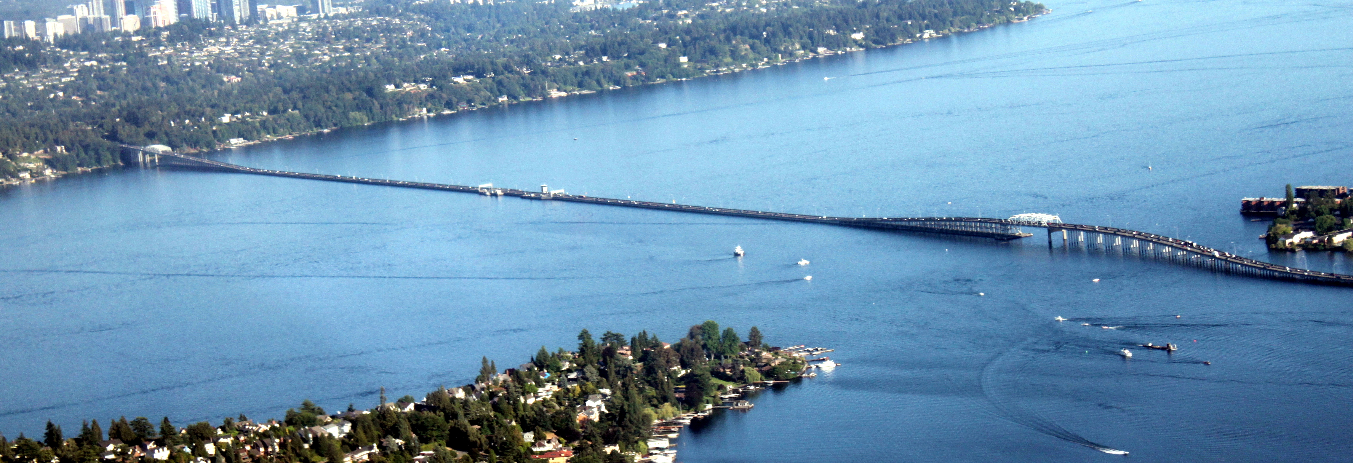
From the Air
The original 1963 bridge has been demolished, but its 2016 replacement occupies the same corridor at 47.641N, 122.260W, crossing Lake Washington between the Montlake neighborhood of Seattle and Medina. From the air, the floating bridge is unmistakable -- a long ribbon of road surface sitting directly on the water, connecting the University of Washington campus area on the west shore to the Eastside communities. The parallel I-90 floating bridges (Lacey V. Murrow and Homer Hadley) are visible approximately 3 miles to the south. Nearest airports: Renton Municipal (KRNT) 10nm south, Boeing Field (KBFI) 10nm southwest, Kenmore Air Harbor (S60) 6nm north. Best viewed at 2,000-4,000 feet on approach from the north or south, where the full length of the floating section is visible against the lake.