Fair Oaks Bridge
The real estate pitch was shameless. Fair Oaks sat in the "heart of California," its promoters declared, the "crown of the Sacramento Valley." Freezes had devastated citrus groves in Florida and Southern California, and a syndicate of Chicago businessmen smelled opportunity in the warm Sacramento foothills. They needed settlers, they needed orchards, and above all, they needed a bridge. Without a crossing over the American River, the fruit would rot before it ever reached the markets in Sacramento. The bridge that eventually rose over those lower banks in 1901 did more than carry wagons of oranges. It carried the fortunes of an entire community.
Sunset Colonies and Broken Promises
In 1895, Brevet Brigadier General Charles Henry Howard and James W. Wilson acquired land rights from California Senator Frederick K. Cox and businessman Crawford W. Clarke. Their Howard-Wilson Publishing Company marketed Fair Oaks as one of their "Sunset Colonies," targeting professionals and businessmen who could afford five-, ten-, and twenty-acre tracts at an average of thirty dollars per acre. By 1897, three hundred permanent settlers had arrived, most of them bankers, engineers, and other city professionals with little farming experience but plenty of optimism. The company promised a bridge over the American River and railroad service from Sacramento, the infrastructure that would connect their orchards to paying customers. Then the investment dried up. Howard-Wilson withdrew from the colony, and with it went the bridge and the railroad. The settlers were stranded on the wrong side of the river with fruit trees that needed a market.
The Bridge That Saved the Colony
Rescue came from local boosters with skin in the game. Valentine S. McClatchy, co-owner of the Sacramento Bee, incorporated the Fair Oaks Development Company in 1900. Chicago investors with land in the colony formed the Chicago-Fair Oaks Club. Together, these two groups lobbied Sacramento County, and in 1901, the first Fair Oaks Bridge opened, along with a new railroad spur. The effect was immediate: Fair Oaks grew rapidly, its citrus production now able to reach Sacramento and beyond. The bridge had turned a failing speculation into a functioning agricultural community. But the American River had its own plans. In March 1907, flooding washed the first bridge away entirely. An 850-foot steel cable was borrowed from the Folsom Development Company to rig a ferry crossing while the county authorized a temporary replacement. The community survived on improvisation while it waited for something permanent.
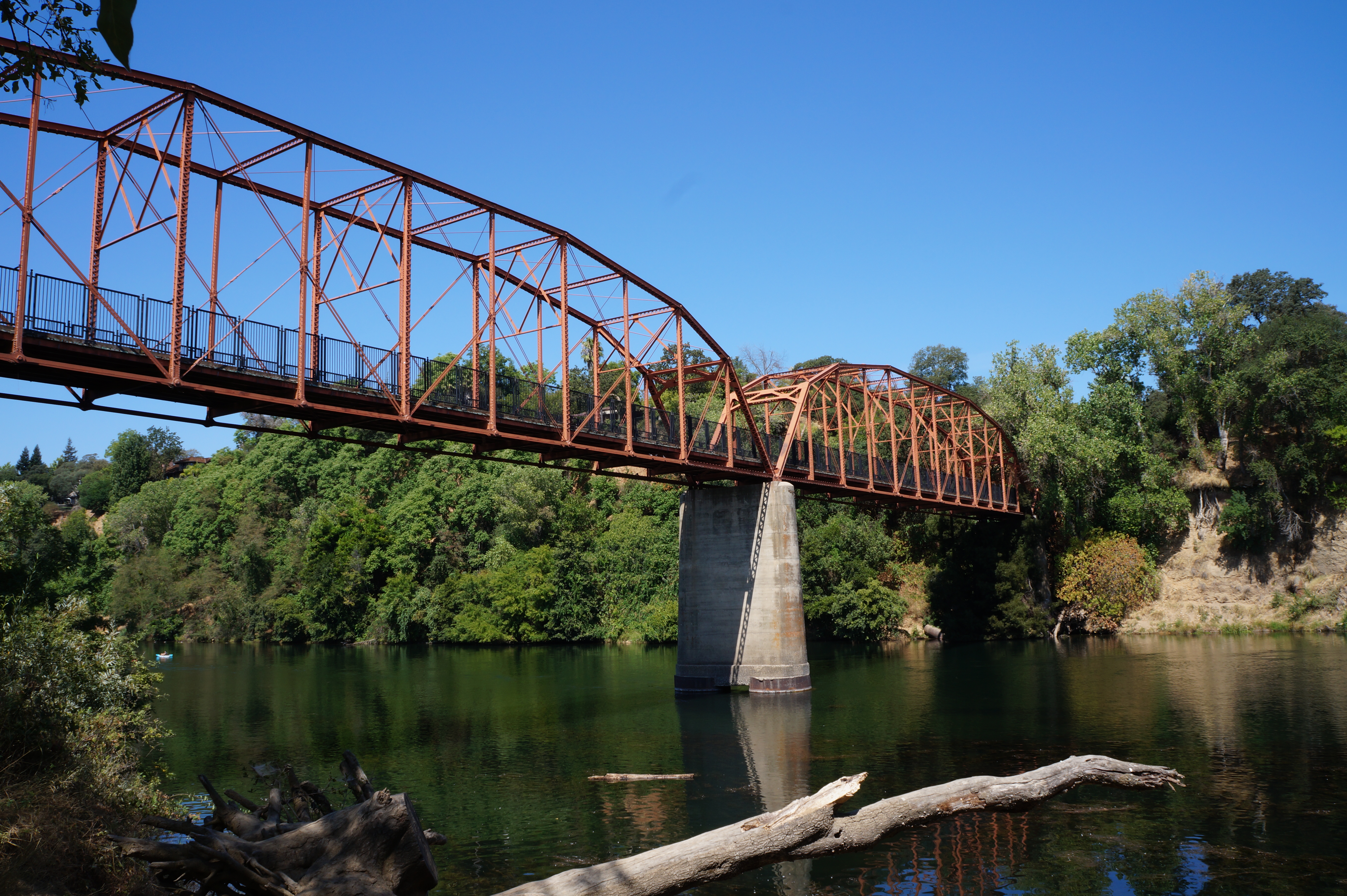
Steel and Triangles
By the end of 1907, the Western Bridge and Construction Company of Omaha, Nebraska, began work on a double Pratt truss bridge, a design that represented the state of the art in early twentieth-century engineering. The Pratt truss form, invented by Thomas and Caleb Pratt in 1844, uses a pattern of triangulated members where diagonal elements carry tension and vertical members carry compression. The Fair Oaks Bridge employed a through-truss configuration, with the deck carried on the lower chord and overhead lateral supports connecting the top chords. Construction cost $63,000 and was completed by 1909. The result was a structure built to last, and it did. More than a century later, the same steel trusses still span the American River, their riveted connections holding firm against the forces that destroyed the first bridge. In September 2006, the bridge was listed on the National Register of Historic Places under both Criterion A, for its associative history, and Criterion C, for its architectural significance.
Bypassed but Not Forgotten
For more than fifty years, the Fair Oaks Bridge served as the primary crossing over the lower American River. The citrus colony it helped build gradually transformed into a bedroom community of Sacramento, the orchards giving way to subdivisions as the twentieth century progressed. Then newer, wider bridges appeared: Watt Avenue in 1959, Hazel Avenue in 1967, and a widened Sunrise Bridge less than half a mile to the west in 1968. The Fair Oaks Bridge, no longer adequate for modern traffic volumes, was closed to automobiles in 1967. Sacramento County Parks and Recreation took ownership, re-decked and painted the structure in 1973, and reopened it as a pedestrian and bicycle crossing. Today the bridge connects to the American River Parkway Trail, a network of paths running along the lower banks of the river. Joggers, cyclists, and dog walkers cross the old steel trusses where wagons once hauled crates of oranges to market.
Iron Bones Over Moving Water
Stand on the Fair Oaks Bridge today and you are standing on layered history. Below your feet, the American River flows southwest toward its confluence with the Sacramento River, the same current that washed away the first bridge in 1907. The Pratt truss members rise on either side, forming the triangulated walls that have resisted wind, flood, and time for more than a century. Upstream, the Sierra Nevada foothills roll toward the Central Valley. Downstream, suburban Sacramento sprawls to the horizon. The bridge occupies a threshold between eras: the agricultural colony that planted orange groves on the bluffs above the river, the suburban expansion that replaced them, and the recreational corridor that now defines the river's banks. The steel is showing its age, the paint weathering in the valley heat, but the geometry holds. Thomas Pratt's 1844 insight about how triangles distribute stress continues to do its work, indifferent to the fact that no one drives across anymore.
From the Air
Located at 38.636N, 121.265W spanning the American River between Fair Oaks and the greater Sacramento area. The truss bridge is a distinctive linear structure visible from lower altitudes, best spotted by following the American River corridor. Sacramento Executive Airport (KSAC) is approximately 14 nm southwest, and Sacramento Mather Airport (KMHR) is approximately 8 nm south. The American River Parkway trail system is visible along both banks. Best viewed at 1,500-3,000 ft AGL to distinguish the historic truss structure from the nearby Sunrise Boulevard bridge less than half a mile to the west.