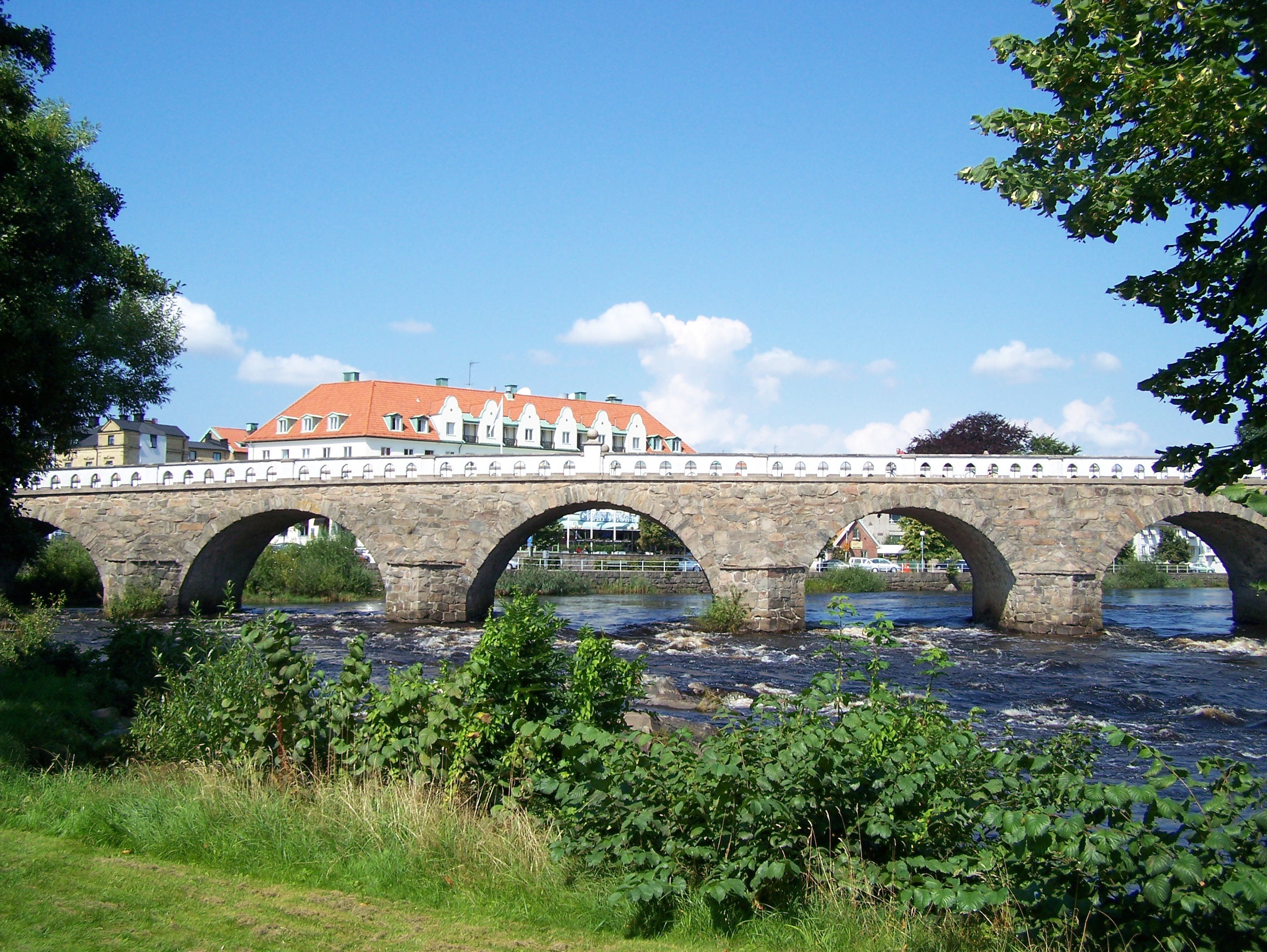
Falkenberg Bridge
King Gustav V rarely involved himself in municipal infrastructure debates. But when Falkenberg's city council voted three times to widen the elegant stone bridge over the Atran River, the monarch made his opinion known: 'It would be a pity to broaden that bridge.' The Tullbron, as locals call it, still carries 3,800 vehicles daily across its five graceful arches, unchanged in width since Swedish soldiers finished laying its stones in 1761.
Soldiers and Architects
County Governor Hans Hummelheim saw the problem clearly: the Atran River needed a permanent crossing. The architect Carl Harleman drew plans for a four-arch stone bridge in 1752, but when he died the following year, Carl Cronstedt took over and added a fifth arch. Construction foreman Fridrich August Rex chose a different location than originally planned, where the river was wider but the bedrock more solid. Soldiers from the Alvsborg and Vastgota-Dal regiments did the heavy lifting. Stone came from Kallstorp in Sloinge, timber from Fagered. When the work finished in 1761, the total cost stood at 34,258 Swedish riksdaler. Rex kept a personal journal of the construction, later published as part of a book on the bridge's history.
The Price of Passage
The bridge earned its Swedish name, Tullbron, from the toll collected for 175 years. A toll house stood beside the crossing, rented out in six-year contracts. The operator paid a fee to the state, maintained the bridge, and kept whatever travelers paid. The arrangement came with a pub on the premises. Travelers heading north paid full price; residents of Arstad and Fauras Hundreds paid half. The toll finally ended in 1914 when Falkenberg took ownership, first exempting townspeople, then everyone. The toll house survived until 1933, having served various purposes including housing the printing press of Falkenbergs Tidning during the newspaper's early years.
A Bridge Worth Fighting Over
By 1939, Falkenberg had grown south of the river, and the beach at Skrea strand drew summer crowds. The city council voted to widen the bridge to accommodate modern traffic. What followed became known as the 'bridge broadening dispute.' Ernst Wigforss and Fredrik Strom led the opposition, eventually recruiting King Gustav V to their cause. The battle raged through local and national authorities for fifteen years. The city council voted three times for widening. Finally, in December 1954, the national government ruled that the bridge's cultural value prohibited major alterations. A temporary footbridge for pedestrians, built in 1955, freed more road space for vehicles. The compromise held until 1962, when a new bridge for the E6 highway relieved traffic pressure entirely.
Echoes of Older Crossings
The Tullbron stands on ground rich with history. Remains of a medieval predecessor lie visible in the streambed near Nybyhemmet, part of the vanished town of Ny-Falkenberg. Another bridge once stood near the current clinic, its foundation boulders still visible. In 1565, one of these earlier bridges was destroyed during war, forcing the Danish army to ford the river upstream at Axtorna. The Swedish army was waiting. The resulting Battle of Axtorna shaped the region's history, a reminder that river crossings have always been contested ground. The ruined fort of Falkenberg still watches from the southern bank, close to where the five stone arches have carried traffic for more than two and a half centuries.
From the Air
Located at 56.90N, 12.49E in the town of Falkenberg on Sweden's west coast. The five-arch stone bridge spans the Atran River in the town center and is recognizable from the air as a distinctive curved structure. The river flows west to the Kattegat, with the popular Skrea strand beach visible at the coast about 2 nautical miles west. Nearest airports include Halmstad (ESMT) approximately 15 nautical miles south and Gothenburg Landvetter (ESGG) 45 nautical miles north. Best viewed at lower altitudes to appreciate the bridge's architecture and its relationship to the historic town center.