Faro Los Morrillos de Cabo Rojo
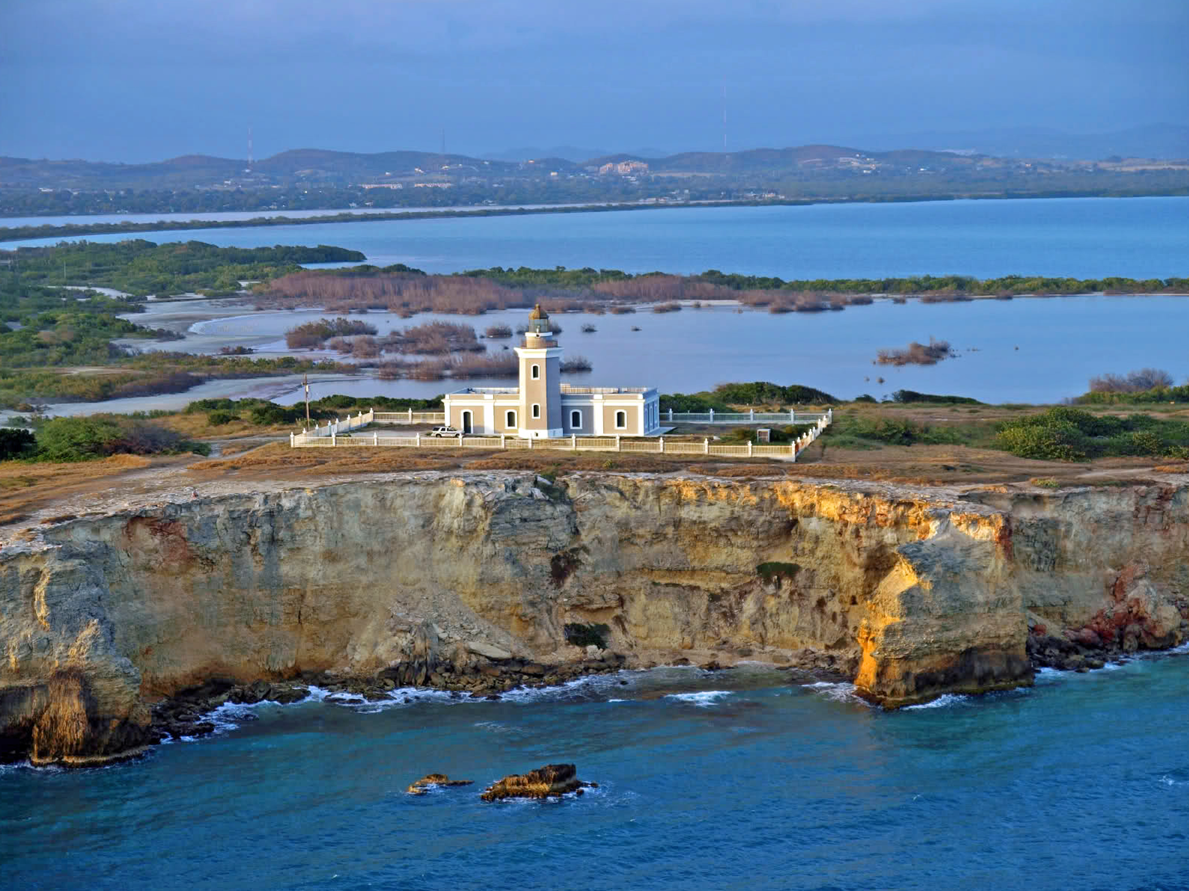
The cliffs drop straight down. Two hundred feet of white limestone fall into turquoise water at the southwestern tip of Puerto Rico, where the Caribbean Sea meets the Atlantic Ocean through the Mona Passage -- one of the most treacherous shipping channels in the region. At the edge of those cliffs, surrounded by salt lagoons and marshes, stands Faro Los Morrillos de Cabo Rojo, a lighthouse completed in 1882 to keep passing ships from joining the wrecks that already littered the passage floor. Its builders chose simplicity over ornament: clean lines, an unelaborated cornice, and a cast-iron, copper, and glass lantern housing a lenticular lens manufactured by the French firm Sautter, Lemonnier and Company.
Guarding the Passage
The Mona Passage runs between Puerto Rico and the Dominican Republic, connecting the Caribbean Sea to the Atlantic Ocean. Currents are strong, weather can shift without warning, and the passage has claimed ships for centuries. The Spanish colonial government built Faro Los Morrillos to mark the southeastern entrance to this corridor, placing the lighthouse where approaching vessels would spot its light from far out to sea. The location was strategic but remote -- the capes of Los Morrillos de Cabo Rojo extend into the water like a bony finger, far from the nearest town. Getting supplies to the construction site in the early 1880s required navigating the same difficult terrain the lighthouse was meant to protect against.
Families on the Cliff's Edge
Two lighthouse keepers and an engineer originally staffed the station, and they did not come alone. Their families lived on the grounds with them, creating a small, isolated community perched above the sea. Life at Los Morrillos meant salt wind, relentless sun, and the constant awareness of the ocean below. The keepers maintained the lantern, trimmed wicks, polished the French-made lens, and kept the light burning through storms that swept across the exposed headland. For decades, the rhythm of their days was dictated by the turning of the lens and the passage of ships below the cliffs. That human presence ended when the lighthouse was renovated and fully automated in 1967, and the keepers' families left the grounds for the last time.
Abandonment and the Fight to Preserve
After automation, the lighthouse structure itself fell into neglect. For decades it stood abandoned on the cliffs, its keeper's quarters slowly deteriorating while the automated light continued to function. Local civic groups, particularly Caborrrojenos Pro Salud y Ambiente, pushed for the old keeper's house to be converted into a museum. The effort gained momentum, and U.S. federal funds were assigned for the restoration. But the project was taken over by the municipal government, a move that caused the loss of those federal funds. The municipality proceeded with its own renovations, which critics say irrevocably damaged the historical significance of the building's interior structure. It is a familiar tension in historic preservation: the urgency to save a building sometimes collides with the expertise needed to save it correctly.
The View From the Edge
What draws visitors to Los Morrillos today is less the lighthouse itself than what surrounds it. The white limestone cliffs are among the most dramatic geological formations in Puerto Rico, their pale faces contrasting sharply with the deep blue and green of the water below. Salt flats and lagoons stretch behind the headland, part of the Cabo Rojo National Wildlife Refuge, creating a landscape that feels far removed from the rest of the island. Trails wind along the cliff tops to the lighthouse, offering views that extend across the Caribbean to the horizon. At sunset, the cliffs glow amber and pink, the lighthouse silhouetted against a sky that earned this corner of Puerto Rico its reputation as one of the most beautiful spots on the island. The light itself still operates, automated and solitary, marking the passage as it has for nearly a century and a half.
From the Air
Located at 17.934N, 67.192W at the extreme southwestern tip of Puerto Rico. The lighthouse sits on dramatic white limestone cliffs that are highly visible from the air, especially against the surrounding turquoise water. Best viewed at 1,500-3,000 feet AGL where the contrast between white cliffs, salt lagoons, and ocean is striking. The Cabo Rojo National Wildlife Refuge extends behind the headland. Nearest airport: Rafael Hernandez Airport (TJBQ/BQN) in Aguadilla, approximately 30 miles north. Mercedita Airport (TJPS/PSE) in Ponce is about 35 miles east. The Mona Passage is visible stretching west toward the Dominican Republic.