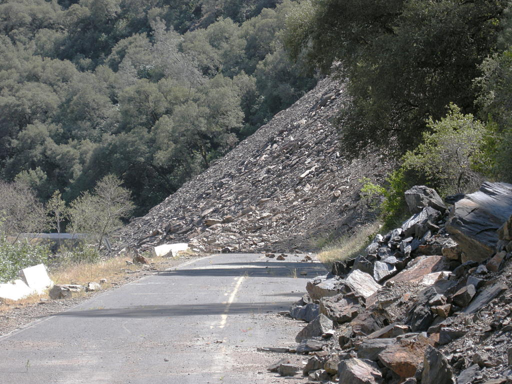
The Mountain That Won't Stop Moving
There is a mountain along the Merced River canyon in Mariposa County that refuses to stay put. In April 2006, a section of Ferguson Ridge detached and slid downhill, burying California State Route 140, one of the most traveled roads into Yosemite National Park. Engineers expected to clear it. The mountain had other plans. Nearly two decades later, the slide is still active, still dropping rock and debris onto the original roadbed, and the permanent fix, a $285 million rock shed, has yet to be built. In the meantime, motorists approaching Yosemite from the west navigate a one-lane detour across temporary bridges, controlled by traffic lights, routed along a road grade left behind by a railroad that ceased operations in 1945. It is the kind of infrastructure problem that sounds temporary until you realize it has lasted longer than most careers.
A Slow Catastrophe
The Ferguson Slide began on April 29, 2006, and at first it seemed manageable. The highway stayed open with monitoring and occasional closures while Caltrans assessed the situation. By May 28, the assessment was complete: the road was closed permanently. The impact was immediate and severe. Route 140 is the most direct path from the town of Mariposa to Yosemite Valley, and many park employees live in Mariposa. Overnight, their commute became a two-hour detour each way. The hospitality industry in the gateway communities, dependent on tourist traffic funneling toward the park, saw revenue collapse. Wages dropped, small businesses shuttered, and county government income from hotel occupancy taxes fell sharply. Mariposa County declared a State of Emergency in June 2006. The irony was difficult to miss: a county whose economy depends on one of America's most famous natural landscapes had been crippled by a natural process as old as the mountains themselves.
Bridges to Somewhere
Caltrans moved quickly to build a workaround. By August 2006, two temporary bridges spanned the Merced River, routing traffic around the slide on the canyon's north side. The detour used an old road grade that dated back to the Yosemite Valley Railroad, which had run through the canyon until 1945. But the bridges had limitations: vehicles over 28 feet could not use them, shutting out tour buses and large RVs during peak season. In June 2008, upgraded bridges capable of handling longer vehicles replaced the originals. Even so, the detour remained one-lane only, controlled by alternating traffic lights. During the height of summer, when thousands of visitors stream toward Yosemite daily, the waits at those lights could stretch long enough to test any traveler's patience. What was supposed to be a temporary fix has now functioned as the permanent reality for the better part of two decades.
The Salamander in the Room
Fixing the road permanently turned out to involve more than engineering. As the slide area stabilized into a new landscape of broken rock and exposed soil, an unexpected resident moved in: the Limestone Salamander, a species found nowhere else on Earth except a small range in the Merced River canyon. The salamander's presence in the slide zone triggered endangered species protections that put any highway repair on indefinite hold. The road could not be rebuilt without disturbing the salamander's habitat, and disturbing the habitat was illegal. In 2012, Assemblymember Kristin Olsen authored Assembly Bill 1973, which allowed the California Department of Fish and Game to relocate the salamanders to an Ecological Reserve, clearing the legal path for construction. Governor Jerry Brown signed the bill on July 13, 2012. It had taken six years just to get permission to move the animals standing between California and its road.
A Quarter-Billion-Dollar Umbrella
With the salamander issue resolved, Caltrans evaluated its options. A tunnel was considered and rejected. The chosen solution is a rock shed: a 675-foot reinforced structure built over the highway alignment that would allow debris to slide harmlessly over the top while traffic passes underneath. The project is split into two phases. Phase 1, which began in early 2021, involves removing approximately 320,000 tons of existing talus and installing cable drapery to reduce ongoing rockfall. Phase 2 is the construction of the shed itself, estimated at $285 million. Rock shed construction was expected to begin in summer 2025, with a five-year timeline. But the mountain continues to complicate matters: as of July 2024, fresh talus material keeps falling, requiring ongoing removal before the shed can be built. Ferguson Ridge is not done moving. The road, for now, waits.
From the Air
Located at 37.657N, 119.901W, in the Merced River canyon along Route 140 between Mariposa and Yosemite Valley. From the air, the slide area is visible as a large exposed rock face and debris field on the south side of the canyon, contrasting with the forested slopes around it. The temporary bridge detour can be seen crossing the Merced River below. Nearest airports: Mariposa-Yosemite Airport (KMPI, 12 nm southwest) and Pine Mountain Lake Airport (E45, 25 nm northwest). Best viewed at 3,000-5,000 feet AGL following the Merced River canyon eastward. Terrain is steep and rugged with limited emergency landing options.