Finke River
Most rivers flow. The Finke mostly waits. For the vast majority of any given year, this ancient watercourse in central Australia is a string of disconnected waterholes scattered along a sandy bed, still and silent under a desert sky. Then the rains come -- rare, unpredictable, sometimes tropical in intensity -- and the Finke becomes a raging torrent that tears through gorges and floods across plains before its water is swallowed by the Simpson Desert. It almost never reaches Lake Eyre, its theoretical terminus some 750 kilometers downstream. The Arrernte people call it Larapinta, and their relationship with this intermittent river stretches back tens of thousands of years.
Older Than the Mountains It Cuts Through
The Finke River is frequently cited as the oldest riverbed in the world, and the evidence is written in the landscape. In places like the James Range, the river flows through deeply incised meanders -- sinuous loops carved into bedrock that could only have formed when the terrain was flat. Because meanders require level ground, the river must have existed before the ranges were pushed up around it, during a mountain-building event called the Alice Springs Orogeny that peaked between 400 and 300 million years ago. The river predates its own gorges. It carved them as the land rose, maintaining its ancient course through sheer persistence, one of the clearest examples of an antecedent stream on Earth. Southern sections of the course are younger, since those areas lay beneath the sea during the Mesozoic Era, but the core of the Finke -- the MacDonnell Ranges section -- is genuinely ancient.
Salt River, Not Snake River
The name Larapinta carries a tangled history. Explorer Ernest Giles, camped at Charlotte Waters Telegraph Station in August 1872, was the first European to record the Arrernte name for the river. He concluded from conversations with Southern Arrernte people that it derived from a gigantic mythological serpent -- the Rainbow Serpent -- believed to have created the waterway, and that larapinta meant "snake." He was wrong. In 1876, Reverend Georg Heidenreich at the Finke River Mission Station at Hermannsburg confirmed the Western Arrernte name as "Lara Beinta," meaning "Salt River." The translation is now widely accepted; certain waterholes along the Finke are permanently salty, and one is called "Salt Hole" in English. Yet the serpent legend persists alongside the correct etymology, both stories coexisting in the telling of a river that predates the English language by hundreds of millions of years.
Six Hundred Kilometers Through the Centre
The Finke's source lies in the MacDonnell Ranges of the Northern Territory, where it begins at the confluence of Davenport and Ormiston Creeks just north of Mount Zeil, the territory's highest peak. From there it meanders roughly 600 kilometers southward to the western edge of the Simpson Desert in northern South Australia, passing through the West MacDonnell and Finke Gorge National Parks. Major tributaries include Ellery Creek and the Palmer and Hugh Rivers. In rare flood events, the water continues into the Macumba River and theoretically into Lake Eyre, completing a 750-kilometer journey from headwaters to salt lake. But the desert usually wins, absorbing the flow long before it reaches any terminal basin.
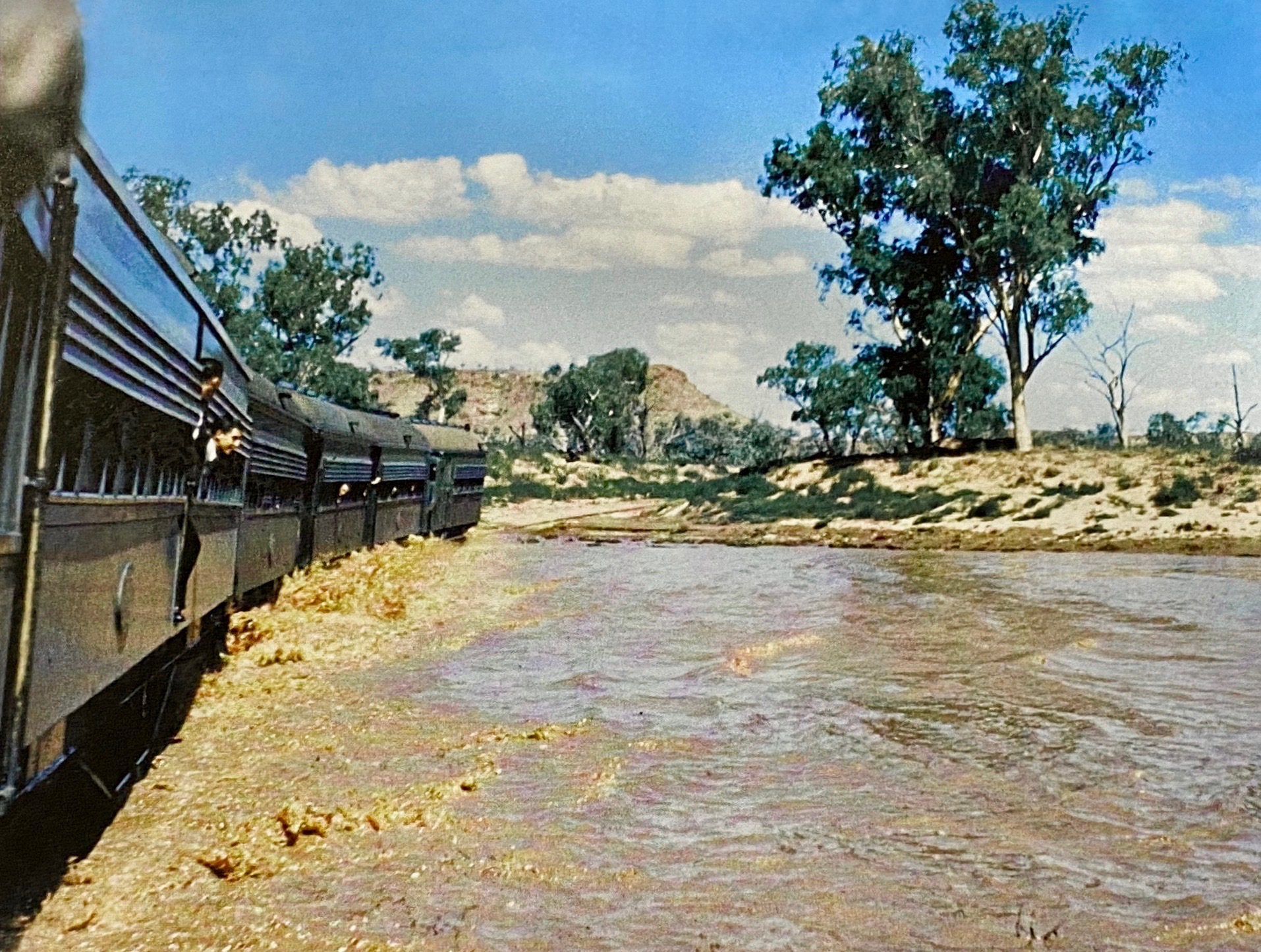
Rails Across the Riverbed
European settlement brought the Central Australia Railway, and the Finke brought the railway grief. Floods repeatedly washed away bridges crossing the riverbed, so engineers eventually laid rails directly on the river bottom -- a pragmatic surrender to hydrology. In February 1953, after two days of waiting at the township of Finke, the water dropped enough for The Ghan -- the legendary steam-hauled train connecting Adelaide to Alice Springs -- to creep slowly across the still-wet riverbed. The image of a locomotive inching through a river captures something essential about the Finke: it operates on its own schedule, and everything else, including infrastructure, must accommodate it.
A River That Tells Its Own Story
Explorer John McDouall Stuart named the river in 1860 after William Finke, an Adelaide businessman who helped finance the expedition. The European name stuck, but the original name has endured in the landscape: Larapinta Drive is the main road west from Alice Springs, an Alice Springs suburb carries the name, and the Larapinta Trail -- one of Australia's premier long-distance walking tracks -- follows the MacDonnell Ranges through country the river has shaped for eons. In 2023, a six-part documentary series called Larapinta, created by Arrernte and Luritja filmmaker Talia Liddle, brought together historians, scientists, and traditional owners to tell the river's story through both academic knowledge and Dreaming songlines. The Finke has always been more than a waterway. It is a thread connecting deep geological time to living Indigenous culture, a river that flows rarely but resonates constantly.
From the Air
The Finke River is located at approximately 24.14S, 132.87E, originating in the MacDonnell Ranges and flowing southward through the Northern Territory into South Australia. From the air, the river is visible as a sinuous, mostly dry sandy channel with scattered waterholes glinting in the sun. The deeply incised meanders through the James Range are particularly striking from altitude. Alice Springs Airport (YBAS) is the nearest major airfield, approximately 200 km to the northeast. The river passes through Finke Gorge National Park and near Hermannsburg. Best viewed at 3,000-6,000 ft AGL to appreciate the meander patterns.