Fire Temple of Isfahan: Where Sacred Flames Once Watched Over Persia
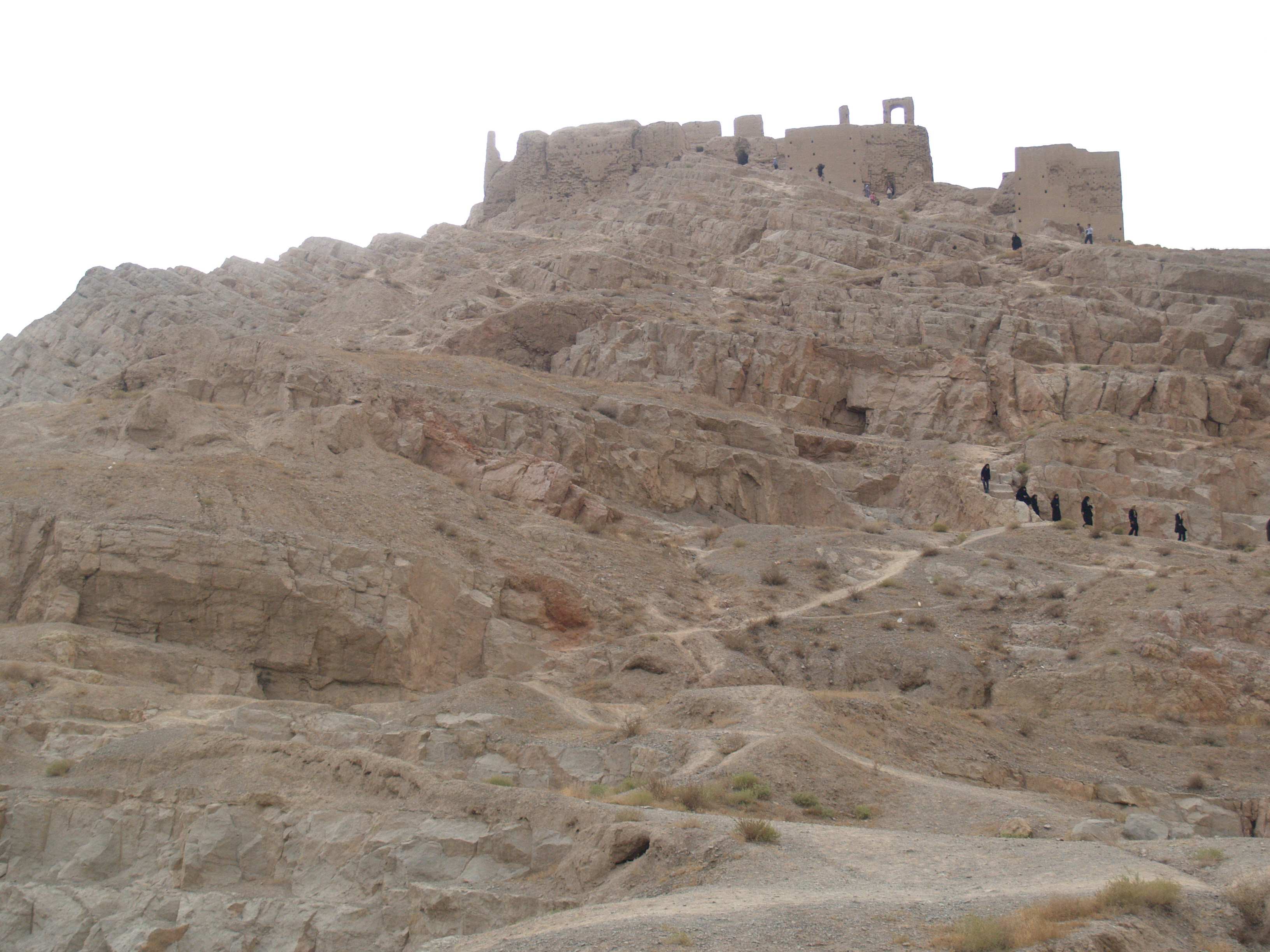
The hill rises 210 meters above the plain west of Isfahan, and from its summit you can see for kilometers in every direction. That visibility was the point. For the Zoroastrian priests who maintained sacred fires here during the Sasanian Empire, the elevation served both spiritual and practical purposes: the flames were closer to the sky they honored, and any approaching enemy was visible long before arrival. The Fire Temple of Isfahan, known locally as Atashgah, sits eight kilometers west of the modern city center, a crumbling complex of mud-brick ruins that once ranked among the most important fire temples in Persia. Arab historians called the hill Maras or Marabin, after a nearby village. The Zoroastrians knew what burned on top of it.
Four Arches for a Sacred Flame
The complex sprawls across the southern flank of the hill: the remains of roughly twenty buildings, some still standing as recognizable walls, others visible only as foundation traces in the clay. Several of these structures share a distinctive floor plan called the chahartaq, or "four arches," the signature design of Zoroastrian fire temples from the third century onward. In this layout, four arched openings face the cardinal directions, creating a sheltered but open space where sacred fire could burn, visible from every approach. The fires were not decorative. In Zoroastrian belief, fire represents truth and righteousness, a physical manifestation of Ahura Mazda's presence. Keeping the flame alive was a sacred obligation. Around these temple chambers, other buildings likely served as storage rooms, living quarters for priests, and lodgings for affluent pilgrims who traveled to tend their devotion.
The Tower of Sacrifice
At the very top of the hill stands a different kind of structure: the remains of a circular tower once at least twenty meters tall. Local people call it the Burj-i Gurban, the "Tower of Sacrifice," though its actual purpose appears to have been military rather than religious. This was a watchtower fitted with a beacon, a flare that could be lit to warn of approaching enemies. The combination makes strategic sense. Fire temples were valuable targets, and a hilltop location that offered spiritual elevation also provided defensive advantage. The tower's circular plan has drawn comparisons to the Chahak fire temple in Qom Province, suggesting a regional architectural tradition. Walls in parts of the complex exceed four meters in thickness, built from mud-brick made with clay, lime, and long stems of reeds, a construction method that has endured centuries of exposure to the Iranian climate.
Older Than Anyone Knew
For decades, scholars assumed the complex dated to the Sasanian period, roughly the third through seventh centuries. Then archaeologist Alireza Jafari Zand published his research on pre-Islamic Isfahan in 2002, and the timeline shifted dramatically. Based on radiocarbon dating, Jafari Zand argued that the site originated as an Elamite temple, which would push its founding to before the sixth century BC, centuries earlier than the Sasanian attribution. The Elamites were one of the oldest civilizations in the region, predating the Persian empires that made Isfahan famous. If Jafari Zand's dating is correct, the hill held sacred significance for more than a millennium before the Sasanian priests built their chahartaq chambers. The temple may have transitioned from Elamite worship to a Mithraic shrine before becoming the Zoroastrian complex whose ruins survive today. French archaeologist Andre Godard first identified the ruins' purpose in 1937, but it was not until architect Maxime Siroux produced the first proper drawings in 1960 that systematic study became possible. Klaus Schippmann confirmed Godard's identifications in 1971.
Crumbling Into the Clay
Today, the Fire Temple of Isfahan is dying by neglect. No formal maintenance program protects the site. Treasure hunters have dug holes throughout the complex, searching for artifacts or valuables rumored to be buried within the ancient walls. No paved path leads to the ruins; visitors pick their own way up the clay hillside, and every footstep on rainy days accelerates the erosion that is slowly melting the mud-brick structures back into the earth they were shaped from. The Zayanderud River flows nearby, the same waterway that gives Isfahan its life, but no preservation effort channels resources toward the hilltop. The site sits on Iran's National Heritage List, a designation that has not translated into active conservation. What remains is still remarkable: the outlines of the chahartaq chambers, the stumps of thick walls, the circular foundation of the watchtower, and the commanding view that explains why someone, thousands of years ago, decided this hill was where the sacred fire should burn.
From the Air
Located at 32.65°N, 51.57°E on a prominent hill approximately 8 km west of Isfahan's city center. From altitude, the Atashgah hill is visible as an elevated feature rising 210 meters above the surrounding plain, west of the Zayanderud River that threads through Isfahan. The archaeological ruins on the hilltop are small but the hill itself is a clear landmark. Isfahan International Airport (OIFM) lies approximately 30 km to the northeast. The Zagros foothills rise to the west; the broad Isfahan plain and city sprawl to the east. The river and its irrigated green corridor contrast sharply with the dry terrain surrounding the temple hill.