First Battle of Elephant Pass
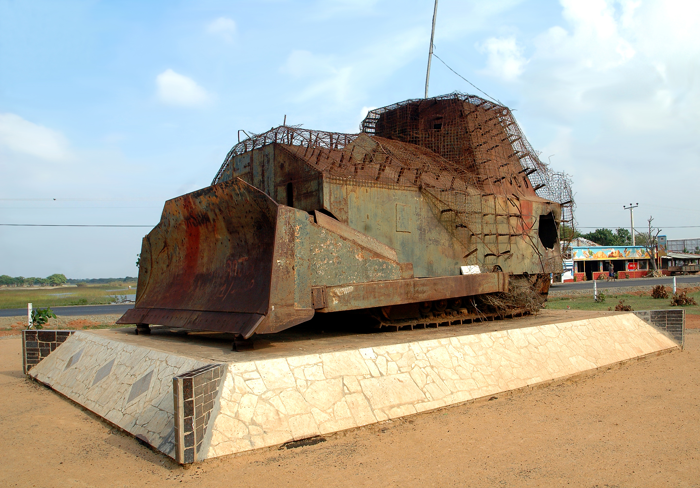
The defenders did not know what they were looking at. As dusk fell over the Elephant Pass base, an armored bulldozer emerged from the LTTE lines -- steel plates welded over an earth-moving vehicle, a machine gun mounted on top, ammunition packed inside. It looked, to the soldiers behind their fortifications, like a tank they had never been briefed on. This improvised weapon, crude and terrifying, became a symbol of the battle that raged through July and August 1991: a fight where conventional military doctrine collided with guerrilla ingenuity on a narrow strip of land that controlled access to an entire peninsula.
The Narrowest Chokepoint
Elephant Pass is geography distilled to a single strategic fact. The narrow causeway connects the Jaffna Peninsula to the Sri Lankan mainland, and whoever holds it controls the only land route between the two. The A-9 Highway and the railway line to Jaffna both thread through this bottleneck. A military base had occupied the site since 1760, when the Portuguese built a fort there. The Dutch rebuilt it in 1776. The British garrisoned it after them. When the Sri Lankan Civil War began, the Sri Lanka Army established a permanent base at Elephant Pass, understanding what every previous occupying power had understood: lose this strip of land and you lose Jaffna. By the summer of 1991, 800 troops of the 6th Battalion of the Sri Lanka Sinha Regiment held the base under the command of Major Sanath Karunaratne.
The Strangling Begins
The LTTE did not simply attack Elephant Pass. They isolated it first. In the weeks before the assault, fighters surrounded the base and blocked the roads north and south, cutting off any possibility of ground reinforcement. At the beginning of July, anti-aircraft guns were moved within range of the base, making helicopter resupply impossible. The 800 soldiers inside were trapped -- a garrison under siege in the oldest sense of the word. On July 10, the LTTE launched their assault from the south. It was, at that time, the most violent confrontation in the history of the civil war. Steel-plated earth-moving vehicles and tractors advanced on the base. Hundreds of mortar rounds fell on Sri Lankan positions. On the first day, the LTTE captured several forward bunkers. On the second day, a mortar attack killed the base's second-in-command.
The Relief That Took Eighteen Days
The Rest House camp in the southern sector fell. The defending troops, sustaining heavy losses, pulled back to their rearward positions. As night came, the LTTE launched wave after wave, surrounding the army's remaining fortifications with hundreds of fighters. Fierce fighting continued for four days before reinforcements could even begin moving. A force of 10,000 troops was dispatched, conducting an amphibious landing at Vettilaikerni, 12 kilometers east of the base. But the relief column met heavy resistance. Every kilometer of advance was contested. It took 18 days -- from mid-July until August 3 -- for the reinforcements to reach the base. Fighting continued for another six days after that before the LTTE began to withdraw on August 9.
The Cost of Holding On
The human toll was staggering by any measure. The Sri Lankan military reported 156 of its soldiers killed and 748 wounded. The LTTE lost 950 fighters killed, according to army figures, though they disputed the number. Later estimates put the combined dead on both sides at roughly 2,000 -- soldiers and fighters who died over a strip of land barely wider than a highway. The president called it the 'Mother of All Battles.' The base held. Major Karunaratne, who led the defense, would eventually reach the rank of Major General. But Elephant Pass was not finished with war. In 2000, the LTTE returned with a different strategy and overran the base in the Second Battle of Elephant Pass. The Sri Lankan Army did not retake it until the Third Battle of Elephant Pass in 2009, part of the final offensive that ended the civil war with the complete destruction of the LTTE. Three battles for the same narrow causeway, spanning 18 years, each one bloodier than the last.
From the Air
Located at 9.55N, 80.41E on the narrow causeway connecting the Jaffna Peninsula to the Sri Lankan mainland. From altitude, the strategic geography is immediately apparent: the Jaffna Peninsula extends northward, connected to the mainland by this thin strip of land flanked by lagoons. The A-9 Highway is visible running through the pass. Jaffna International Airport (VCCJ) is approximately 30 nautical miles to the north. Palaly Air Force Base is nearby. The area's flat, low-lying terrain and surrounding water make the chokepoint geography visible even from high altitude. A war monument now stands at Elephant Pass.