Flamenco Beach
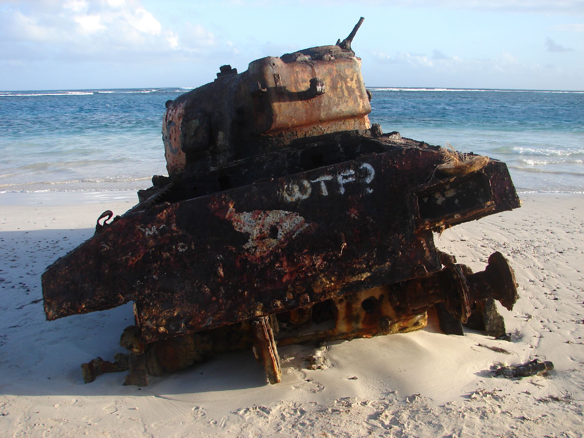
Two M4 Sherman tanks sit half-buried in the sand at one end of the beach, their hulls layered in decades of graffiti -- bright pinks, blues, yellows applied by visitors who probably don't know why the tanks are here. For over thirty years, the US Navy used Culebra as a bombing range, pounding this horseshoe bay with ordnance while residents lived just a few miles away. In 1970, the people of Culebra fought back -- not with weapons but with their bodies, forming human chains to block missile fire, building a chapel on the beach the Navy had claimed. By 1975, the Navy was gone. The tanks stayed behind, rusting slowly in the salt air, becoming what might be the most surreal photo opportunity in the Caribbean.
Where the Flamingos Were
The beach takes its name from the Caribbean flamingos that once gathered in the lagoon behind the shore -- Laguna del Flamenco, where flocks of Phoenicopterus ruber waded in shallow water. The flamingos are gone now, but the lagoon remains, separated from the sea by a mile-wide crescent of white sand that curves around Bahia Flamenco like a cupped hand. The reef breaks about a quarter mile offshore, and inside that barrier the water is startlingly calm -- shallow enough to wade far out, clear enough to see parrotfish and blue tang drifting over sea grass. The Culebra National Wildlife Refuge borders the beach, one of the oldest wildlife preserves in the United States. Each summer, some 50,000 sooty terns and other seabirds descend on the Flamenco Peninsula to nest, and leatherback and hawksbill sea turtles still come ashore to lay their eggs on quieter stretches of sand.
The Bombing Range Next Door
Starting in 1936, the US Navy designated Culebra for bombing practice. By the late 1960s, missiles were striking the island on 228 days a year as pilots trained for Vietnam. The residents of this small island-municipality of Puerto Rico -- fewer than a thousand people -- lived with the concussions, the craters, the unexploded ordnance scattered across their landscape. Flamenco Beach itself fell within the Navy's target zone. A church that had stood near the shore was demolished to make way for military exercises. The island was riddled with toxic waste. For the Navy, Culebra was a convenient piece of empty geography. For the people who lived there, it was home -- and they were determined to reclaim it.
The Fight for Culebra
In the summer of 1970, twenty Culebrans linked arms on the beach to form a human chain, blocking ship-to-shore missile fire. The Puerto Rican Independence Party organized a three-day encampment that drew 600 people. Activists with the Rescue Culebra Committee and A Quaker Action Group attempted to build a chapel on Flamenco Beach, right in the bombing range, on the site where the Navy had torn down the church. Authorities demolished the chapel and sent fourteen protesters, including independence leader Ruben Berrios Martinez, to federal prison for trespassing. But the arrests backfired -- students rose up at the University of Puerto Rico, daily vigils formed outside the jail, demonstrators gathered in Washington, and replica chapels appeared outside the Pentagon. Four years of sustained nonviolent resistance wore the Navy down. In 1974, President Nixon ordered the military to leave Culebra by 1975.
Paradise with a Past
Today Flamenco Beach regularly ranks among the best beaches in the world -- TripAdvisor named it third globally in 2013, and it regained its Blue Flag Beach certification in 2016. Ferry boats arrive from the town of Dewey carrying day-trippers who spread out along the sand, buy pina coladas and fish skewers from the half-dozen kiosks, and snorkel over reefs thick with wrasse and parrotfish. Campers pitch tents in a designated area with showers and potable water. The horseshoe bay provides a long walking path, and surrounding trails lead to bird-watching spots where the summer tern colonies wheel overhead. And at the far end of the beach, the Sherman tanks stand in their coats of spray paint -- corroding, cheerful, impossible to ignore. They are monuments, though not the kind anyone planned: monuments to what happens when a community decides that paradise is worth fighting for.
From the Air
Located at 18.33N, 65.32W on the northwestern coast of Culebra, Puerto Rico. The horseshoe-shaped Flamenco Bay is clearly visible from altitude as a bright turquoise crescent against the green island. Nearest airport is Culebra's Benjamin Rivera Noriega Airport (TJCP), a small single-runway field. Larger airports include Luis Munoz Marin International (TJSJ) in San Juan, approximately 17nm to the west. The island of Culebra sits between the main island of Puerto Rico and the US Virgin Islands. Approach from the north for the best view of the beach's full horseshoe shape. Clear conditions typical year-round; tropical afternoon showers possible.