Folsom Dam
On the morning of July 17, 1995, a diagonal brace between two struts on Spillway Gate 3 snapped. Within moments, the gate failed completely, releasing nearly 40 percent of Folsom Lake in an uncontrolled flood down the American River. The freshwater surge reached San Francisco Bay weeks ahead of schedule, confusing salmon and striped bass whose instincts told them fall rains had arrived. It was a summer day. This is the story of Folsom Dam: a 340-foot wall of concrete holding back one of California's most important reservoirs, where engineering, ecology, and the relentless power of water meet in constant negotiation.
A Dam Before the Dam
The current Folsom Dam replaced an earlier structure completed in 1893 by Horatio Gates Livermore. That first dam fed the Folsom Powerhouse, which transmitted electricity to Sacramento over what was then the longest electrical distribution line in the world. The remains of that pioneer dam can still be seen downstream from the modern Folsom Lake Crossing. When Congress authorized a new dam in 1944, it was for flood control alone. By 1949, the project had expanded to serve multiple purposes: flood protection, hydroelectric power, irrigation, and municipal water supply. Construction began in 1951. Flooding washed out the temporary cofferdam three times in 1953, delaying work and damaging the downstream Nimbus Dam then under construction. The final concrete was poured on May 17, 1955.
Engineering on a Massive Scale
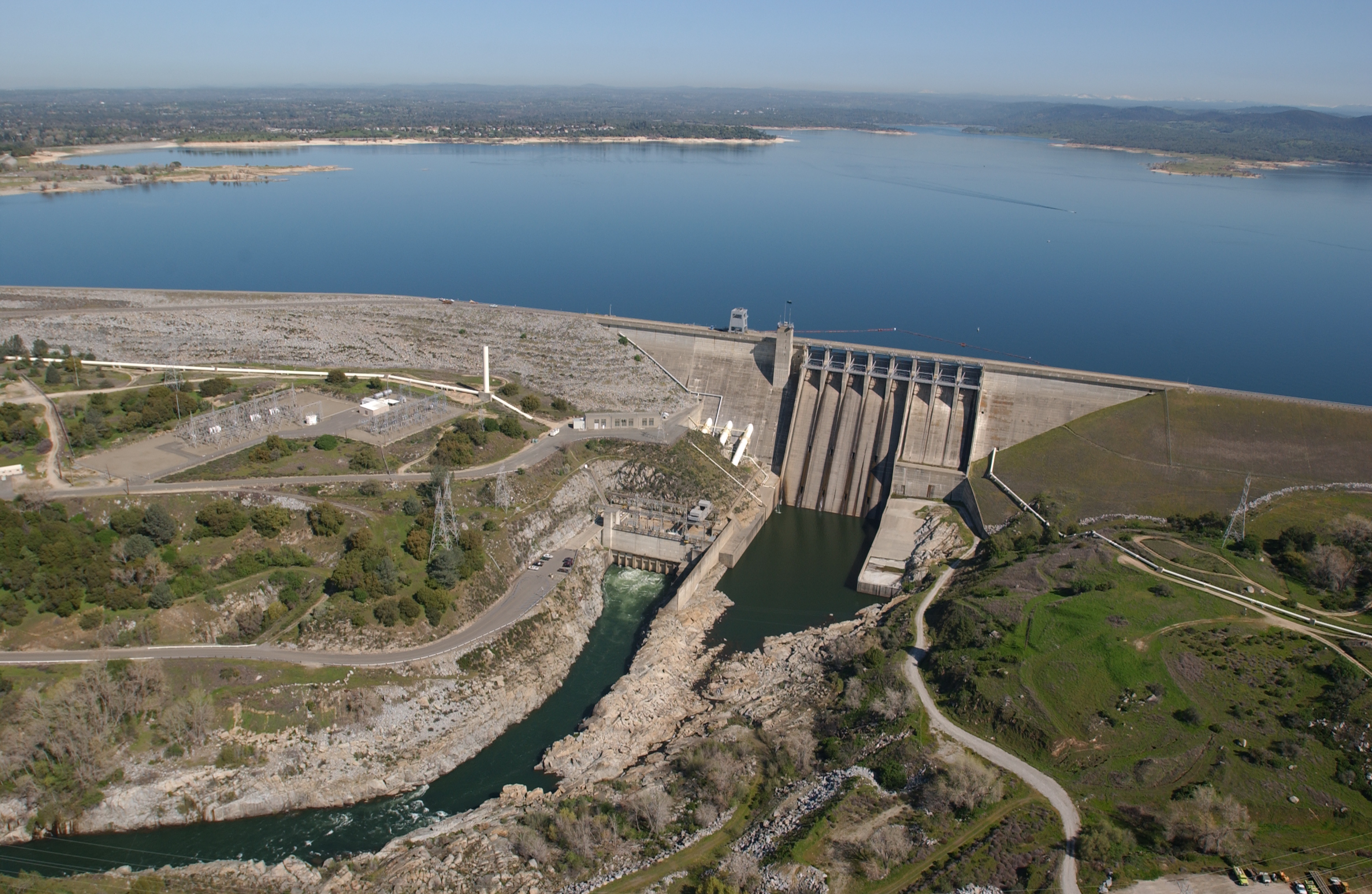
Folsom Dam rises 340 feet above the junction of the north and south forks of the American River, stretching 1,400 feet across the canyon. The hollow-core concrete gravity dam is flanked by wing dams and saddle dams that, combined with eight dikes, total more than four miles of barriers holding back the reservoir. Eight radial gates control the main spillway. Three Francis turbines in the powerhouse generate nearly 199 megawatts of electricity, upgraded from the original 162 megawatts in 1972. The dam and reservoir control runoff from 1,875 square miles, capturing 87.6 percent of the American River watershed. To build it, the government relocated families from 142 properties, including the settlements of Mormon Island and Salmon Falls, now submerged beneath Folsom Lake.
When the Gate Failed
The 1995 spillway failure traced to a slow accumulation of problems. The original design had not accounted for trunnion friction, the resistance at the pin-hub interface where the gate pivots. Over decades, corrosion gradually increased that friction. Budget constraints led to less frequent maintenance. A new environmentally-friendly lubricant proved insufficiently waterproof, allowing water into the mechanism. When Gate 3 was operated that July morning, the increased friction exceeded the capacity of the diagonal brace connection. The brace failed, redistributing load until the struts buckled. The gate collapsed. No one died, but the Bureau of Reclamation emerged from the year-long investigation facing hard questions about maintenance priorities and the gap between design assumptions and real-world degradation.
Floods and the City Downstream
Sacramento has always lived at the mercy of the rivers that made it prosperous. December 1964 brought record inflows to Folsom Lake. February 1986 forced engineers to open the spillway gates after heavy rains, threatening half a million residents. The New Year's Day storm of 1997 sent one million acre-feet of water into the reservoir over five days, equal to the lake's entire capacity. That storm was a rain-on-snow event: warm tropical moisture melted Sierra snowpack at lower elevations, effectively doubling the runoff. The Bureau of Reclamation's Safety of Dams Program has labeled Sacramento one of the most flood-vulnerable communities in America. In October 2017, the Corps of Engineers completed a new auxiliary spillway with gates set lower than the original, allowing operators to evacuate reservoir storage more efficiently before floods arrive.
Life in a Security Zone
After September 11, 2001, the Bureau of Reclamation closed Folsom Dam Road. The road over the dam had been a major artery for the city of Folsom, and its closure created severe rush-hour congestion. Residents and city officials petitioned for reopening, but security concerns prevailed. In 2009, the Folsom Lake Crossing bridge opened, bypassing the dam entirely. Today, half a million people live in the dam's shadow, their safety depending on concrete poured seven decades ago, maintained by agencies navigating budgets, climate change, and the unpredictable hydrology of a warming Sierra Nevada. The dam remains a critical piece of the Central Valley Project, one link in the system of reservoirs and canals that makes California's agricultural abundance possible.
From the Air
Located at 38.71N, 121.16W, approximately 25nm northeast of Sacramento. The dam spans the American River canyon with Folsom Lake extending into the Sierra foothills to the east. Visible landmarks include the main concrete dam, wing dams, powerhouse on the north bank, and the 2009 Folsom Lake Crossing bridge downstream. Sacramento Mather Airport (KMHR) lies 12nm southwest; Sacramento Executive (KSAC) is 20nm west. Lake elevation varies seasonally; spring often shows the reservoir at capacity while late summer may reveal the old mining settlements on exposed shorelines.