Ford Island
Ancient Hawaiians called it Mokuumeume -- "isle of attraction" -- and used it for a fertility ceremony that involved singing around bonfires while a tribal leader touched chosen men and women with a maile wand. Christian missionaries shut down the ritual in the 1830s. Since then, Ford Island has been a Spanish deserter's goat ranch, a sugarcane plantation, an Army airfield, a Navy air station, the epicenter of the most consequential military attack in American history, and a national historic landmark so neglected that the National Trust for Historic Preservation once listed it among the country's most endangered sites. All of this on 441 acres in the middle of Pearl Harbor.
From Bonfire to Barracks
Kamehameha I gave the island to Francisco de Paula Marin, a Spanish deserter who raised sheep, hogs, goats, and rabbits there to provision passing ships. The monarchy reclaimed it, and in 1865 it sold at public auction for $1,040 to James Isaac Dowsett, who immediately resold it to Caroline Jackson for one dollar. Dr. Seth Porter Ford married Jackson in 1866, and the island took his name. After Ford's death, his son sold the island to the John Papa Ii estate, which converted it into a sugarcane plantation. Aqueducts carried freshwater from reservoirs, and harvested cane went by barge to Waipio and then by rail to the mills. The U.S. military had been eyeing the island since 1873, when a commission recommended trading it for tax-free sugar imports. In 1917, the Ii estate finally sold part of Ford Island to the Army for construction of an airfield -- though the Army valued the land at $30 per acre against the estate's asking price of $600.
Runway and Runway
What began as a rough landing strip became, by 1918, a working military air station with steel-and-wood hangars, concrete seaplane ramps, a machine shop, and a photography laboratory. The Army took the west side, the Navy the southeast. Naval Air Station Pearl Harbor was commissioned on December 19, 1919, with nine officers and fifty-five men. Early aircrews flew Curtiss HS2L flying boats and N-9 trainers salvaged from World War I. Through the 1920s and 1930s, Ford Island grew into a strategic hub for Pacific operations. The Navy dredged the surrounding harbor to deepen the lochs for battleship mooring, building a concrete-and-stone quay around the entire island. Construction of Hickam Army Airfield on the mainland side of the harbor eventually drew Army aviation off the island, but the Navy expanded its facilities to accommodate the growing Pacific Fleet.
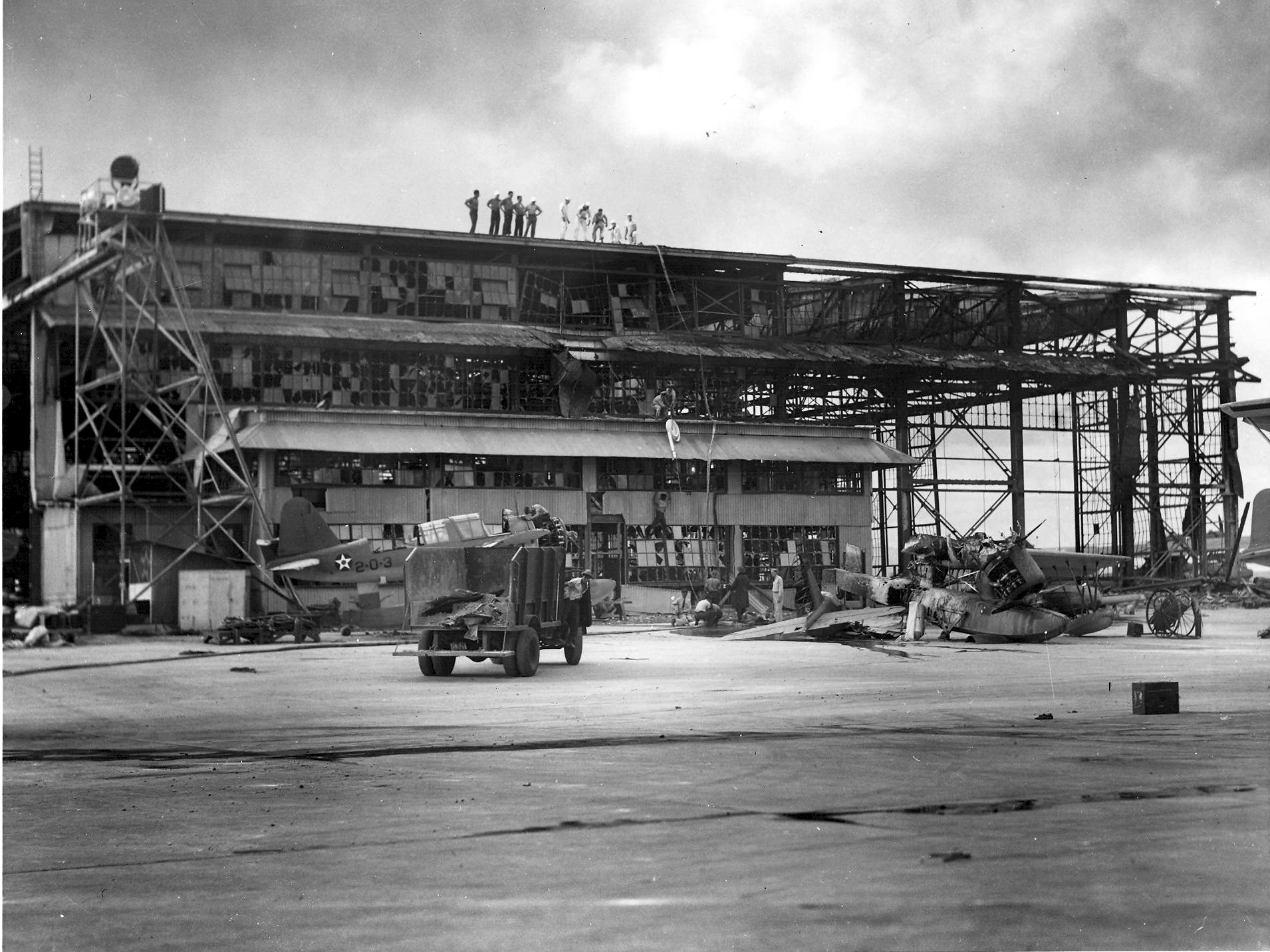
The Center of the Storm
On December 7, 1941, Ford Island sat at the literal center of the attack on Pearl Harbor. Battleship Row ran along its southeast shore, where eight battleships were moored in pairs at quays F6, F7, and F8. Japanese torpedo bombers flew at mast height across the harbor, their weapons aimed at the ships lining the island's edge. The island's airfield was hit simultaneously. Hangars burned, aircraft were destroyed on the ground, and personnel scrambled for weapons and cover. The Ford Island control tower transmitted the first radio alert of the attack -- the famous message that included the words "Air raid, Pearl Harbor. This is not a drill." By the time the second wave withdrew around 9:45 a.m., the harbor around Ford Island was burning, choked with oil and wreckage, and 2,403 Americans were dead.
Memorials in Every Direction
The island today is ringed by memory. The sunken hull of USS Arizona lies off its southeast shore, the white memorial structure visible from the island's roads. USS Utah, relegated to a target ship before the attack, remains capsized off the northwest side -- a memorial dedicated in 1972 to the fifty-eight men still entombed within. USS Missouri arrived in 1999, moored on the northeast side, and the USS Oklahoma memorial was dedicated nearby in 2007. The Pearl Harbor Aviation Museum opened in Hangar 37 in 2006, its walls still bearing bullet holes from the attack. The island's control tower, which sent the first alert, was leased for restoration in 2010. Access to Ford Island is via the Admiral Clarey Bridge, a unique structure with a floating section that opens to allow ship passage but cannot carry cable lines across the loch.
An Island Still at Work
Ford Island is not a museum frozen in time. It remains an active military installation within Joint Base Pearl Harbor-Hickam. Navy housing occupies parts of the island, and the Fleet Integrated Synthetic Training/Testing Facility, unveiled in 2013, uses simulators and virtual reality for naval warfare training. The Sea-based X-band Radar, a billion-dollar warhead-detection platform on a self-propelled floating base, has docked at Ford Island repeatedly since 2006 for maintenance. The Daniel K. Inouye Pacific Tsunami Warning Center operates from the island, though its location in a tsunami-vulnerable area, accessible only via a bridge that must open for ship evacuations, has drawn criticism. Ford Island's present is as layered as its past -- military operations, historic preservation, and the daily logistics of maintaining an island that has been at the center of American Pacific strategy for over a century.
From the Air
Ford Island is located at 21.364N, 157.960W in the center of Pearl Harbor's East Loch, clearly visible from the air as an oval-shaped islet roughly 1.5 miles long and 0.75 miles wide. The island has a visible runway (now closed to regular aviation since 1999), and is connected to the mainland by the Admiral Clarey Bridge on its south side. Battleship Row sites are along the southeast shore. USS Missouri is moored on the northeast side. The island is within Joint Base Pearl Harbor-Hickam restricted airspace. Nearest airport is PHNL (Daniel K. Inouye International). Do not overfly without authorization.