Fore Abbey
Count the wonders at Fore and you will get seven, though not all of them are what they seem. A monastery built on a bog. A mill that runs without a visible water supply. Water that flows uphill. A tree that will not burn. A well whose water never boils. An anchorite sealed in a cell. A massive lintel stone raised by prayer alone. These are the Seven Wonders of Fore, attributed to Saint Feichin, who founded a monastery here in 630 AD near Lough Lene in County Westmeath. Some are genuine mysteries. Others have practical explanations that make them no less remarkable -- like the mill "without a race," which actually draws water from Lough Lene through underground limestone channels.
Feichin's Community
Saint Feichin established his monastery at Fore -- from the Irish Fobhair, meaning "water-springs" -- in the 7th century. By the time of his death in 665, he had attracted about 300 monks to the community. The name itself came from Feichin's spring, which still flows beside the remains of the original church. But survival was never guaranteed. Between 771 and 1169, Fore Abbey was burned twelve times by successive waves of invaders: Vikings under Lord Turgesius, who had established a fort at nearby Lough Lene; the O'Reilly lords of Breifne; and others who saw the monastery's wealth as an invitation. A small high cross in solid masonry, possibly from the 10th century, still marks the original entrance -- a stubborn survivor of the same fires that claimed everything around it.
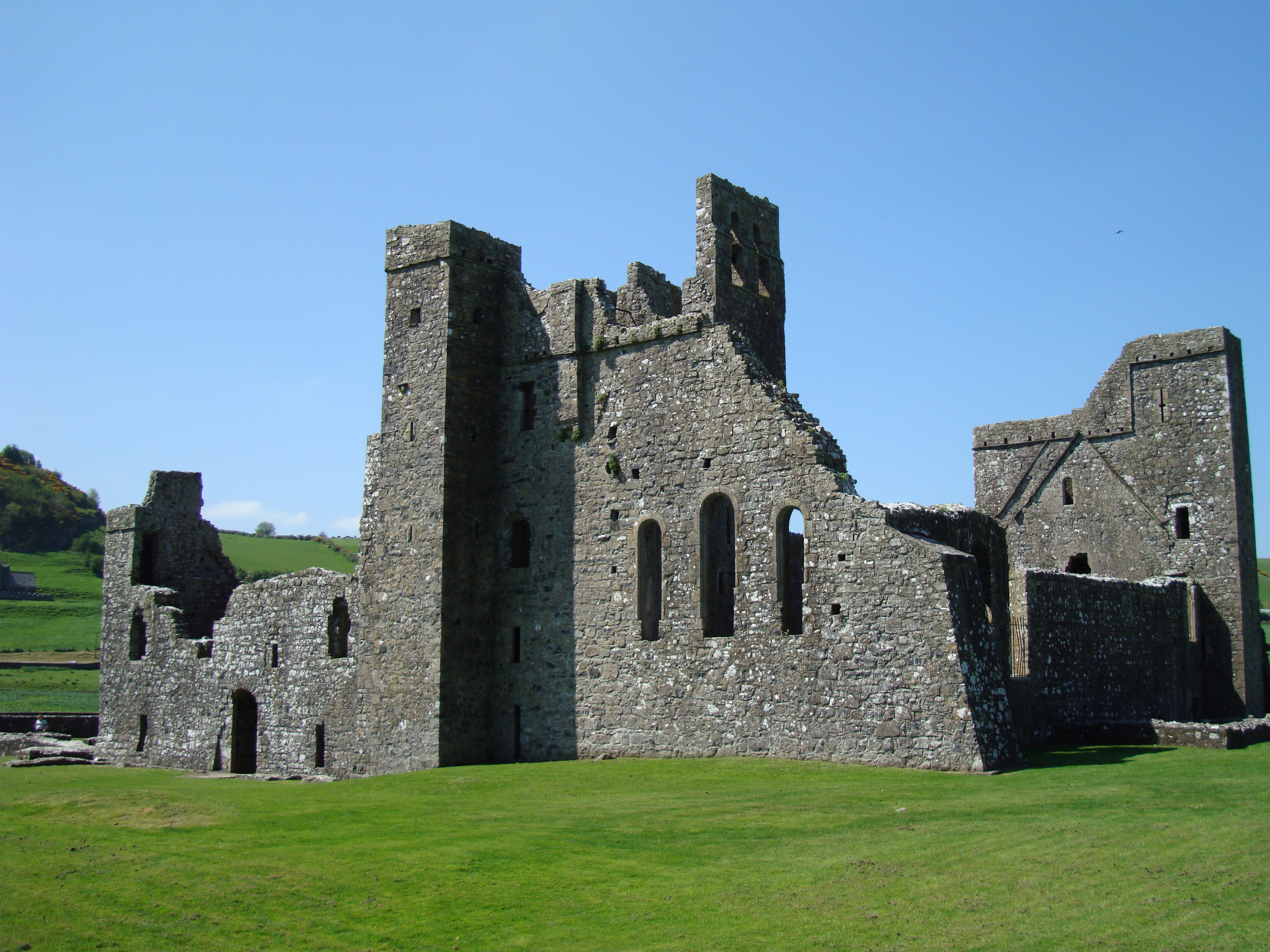
Norman Ambitions
Around 1200, the Gaelic abbey was secularized, and Hugh de Lacy, Lord of Meath, built a Benedictine priory in the valley nearby. Dedicated to both Saint Feichin and Saint Taurin of Evreux, it was established as a cell of the Abbey of Evreux in France. The ruins visible today -- the graceful arcaded cloister, the church with traces of painted plaster decoration, the broken walls of two towers -- date mostly from the 13th and 15th centuries, with 20th-century restoration work. The priory was always small. Despite claims of large monastic populations, medieval Fore likely never housed more than a handful of monks under a prior, most of them drawn from the Anglo-Norman aristocracy. As a cell of a foreign house, its lands were seized by the English Crown whenever England and France went to war.
The Wonders Endure
The Seven Wonders have outlasted every phase of Fore's history, accumulating layer upon layer of meaning. The "monastery built on a bog" reflects the genuine engineering challenge of constructing on waterlogged ground. The "tree that won't burn" -- also called the tree with three branches -- has become the "copper tree," its bark embedded with coins pressed into it by pilgrims over the centuries. The anchorite's cell, a small tower house on the slope above the churches, gained a 19th-century mausoleum for the Nugent family, giving the whole structure the misleading appearance of a church. And that enormous lintel stone above the doorway of the 7th-century church? Feichin reportedly raised it by prayer. Geology offers no better explanation for how Neolithic-scale engineering arrived at a modest country church.
Crosses on the Road
Beyond the abbey complex, eighteen stone crosses are scattered along roadways over a seven-mile radius -- the Fore Crosses, marking the extent of the monastery's medieval landholdings, which encompassed many townlands and parishes around Castlepollard. Some crosses remain intricately carved; others have been worn smooth by centuries of wind and rain, their details erased. One stands in the village of Fore itself. These markers remind visitors that the abbey was never just a cluster of buildings but the center of a vast ecclesiastical landscape. The lands associated with Fore in the Middle Ages were extensive, and the crosses served as boundary stones, wayside shrines, and declarations of sacred territory in a countryside that has been farmed continuously for over a thousand years.
From the Air
Located at 53.68°N, 7.23°W near the village of Fore in County Westmeath. The abbey ruins are visible from low altitude in the valley north of Lough Lene. Nearest airport: Abbeyshrule Aerodrome (EIAB), approximately 40 km to the southwest. The landscape is rolling midland farmland with Lough Lene as a visual reference point.