Fort Davidson
A crater in the Missouri earth tells the story. Not the slow work of geological erosion but a single violent instant -- the detonation of a powder magazine by Union soldiers fleeing a fort they had defended all day and chose to destroy rather than surrender. Fort Davidson, a hexagonal earthwork near the town of Pilot Knob, was never a grand fortification. It was a practical solution to a practical problem: protecting iron deposits and a railroad terminus in the rugged St. Francois Mountains. Built in 1863, occupied for barely a year and a half, and blown apart by its own garrison on the night of September 27, 1864, the fort's brief active life produced one of the most consequential engagements of the Civil War's Trans-Mississippi Theater.
Iron and Rails
Fort Davidson replaced an earlier fortification called Fort Hovey, later renamed Fort Curtis after Major General Samuel R. Curtis. That first fort, built in 1861 and armed with four 32-pounder cannons, three 24-pounder howitzers, and two Coehorn mortars, sat in the wrong place -- too far from the iron deposits and railroad it was supposed to guard. Fort Davidson was constructed in 1863 at the base of Pilot Knob itself, positioned to command both resources. Its builder chose a hexagonal plan with earthen walls, surrounded by a moat. Rifle pits extended to the north and southwest. The underground magazine was covered with layers of dirt and wood planking. The fort was named for Brigadier General John Wynn Davidson, who had commanded Union troops in the area in 1862.
A Fort Built for Hundreds, Holding Thousands
When Confederate Major General Sterling Price descended on the Arcadia Valley in September 1864 with roughly 13,000 men, the fort's garrison under Brigadier General Thomas Ewing Jr. numbered only 1,456. The hexagonal walls were packed well beyond capacity, but Ewing turned this overcrowding to advantage during the battle on September 27. While one line of soldiers fired, another reloaded, maintaining a withering rate of fire that shredded wave after wave of Confederate attacks. Few attackers even reached the moat. Those who did could not breach the walls. Brigadier General William Cabell's brigade charged three times; on the last attempt, some men crossed the moat only to be repelled by hand grenades. Confederate losses ran between 800 and 1,000. Union casualties totaled 213.
The Night the Fort Died
Price ordered ladders built for a renewed assault at dawn. Ewing had other plans. That night, the entire garrison filed out of the fort, slipping past Confederate sentries who never detected the movement. A rear detachment lit the fuse to the magazine. The explosion ripped open the fort's interior, creating a crater that remains visible more than 160 years later. The Confederates, astonishingly, did not react to the blast or discover the evacuation until morning. The men killed in the day's fighting were buried by Confederate soldiers in a mass grave on the site. The fort's active military life was over, less than two years after it was built.
From Livestock Corral to State Park
After the war, a mining company used the fort's enclosure as a livestock corral. Union veterans held commemorative gatherings at the site beginning in 1882, and Grand Army of the Republic meetings took place within the old walls. The Pilot Knob Memorial Association eventually acquired the property, though attempts to designate it a national battlefield failed. The land passed through private hands to the U.S. Forest Service, and in 1968, the Battle of Pilot Knob State Historic Site was established as a Missouri State Park. The fort was added to the National Register of Historic Places on February 26, 1970. The Missouri Department of Natural Resources took full control of the site in 1987.
Walking the Hexagon Today
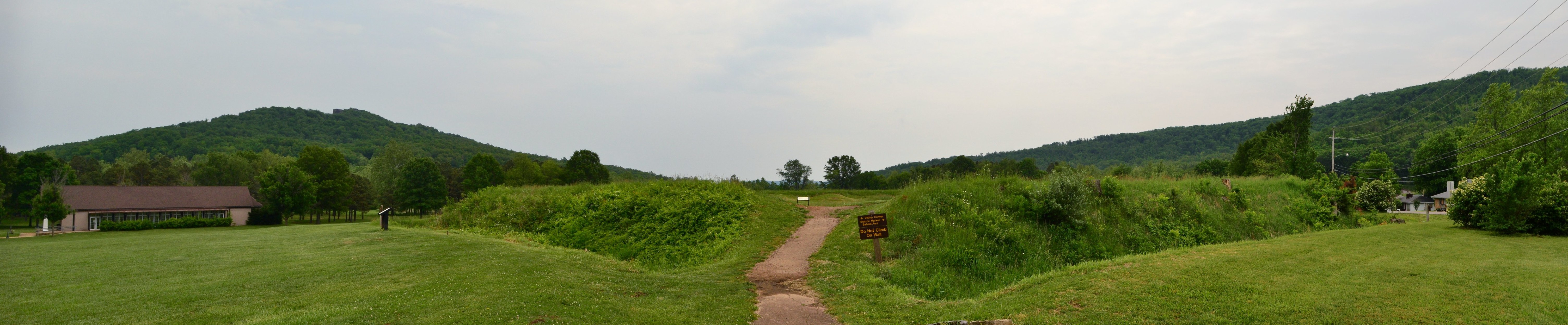
The ruins of Fort Davidson preserve the geometry of a desperate defense. The earthen walls still trace the hexagonal outline, reduced by time but unmistakable in shape. The magazine crater gapes in the fort's interior, a lasting scar from that September night. A granite monument over the mass grave bears the inscription: 'Whatever transgressions existed on either side, let the passage of time bury amid the ruins of the past.' The park logged 130,065 visitors in 2023. A visitors center houses artifacts, a fiber optic battlefield display, and Ewing's sword. The American Battlefield Trust has worked to preserve additional land around the site, and archaeological excavations continue to uncover projectiles and military artifacts from the fighting.
From the Air
Located at 37.6197°N, 90.6400°W near Pilot Knob, Iron County, Missouri, at approximately 900 feet MSL. The fort sits in a valley defined by four prominent hills: Pilot Knob (south), Shepherd Mountain (east), Rock Mountain (northwest), and Cedar Hill. The hexagonal earthwork and crater are visible from low altitude. Nearest airport is Farmington Regional Airport (KFAM) about 15 nm northwest. The surrounding landscape is characteristic rugged Ozark hill country with dense forest cover. Best viewing altitude 2,000-4,000 feet AGL.