Fort Ebey State Park
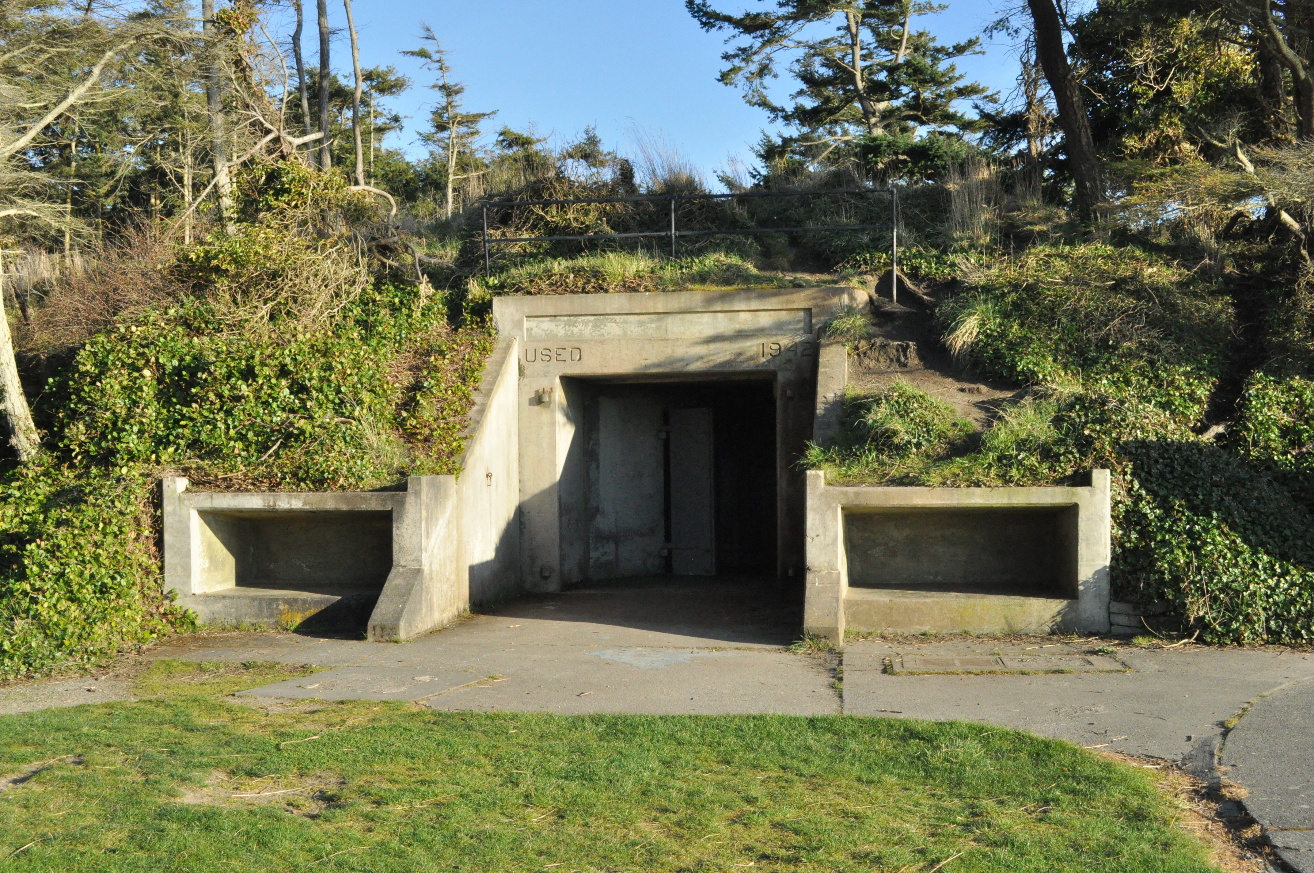
The concrete is cold even in August. Step inside one of Fort Ebey's gun emplacements and the temperature drops ten degrees, the ocean wind cut off by walls built to absorb naval bombardment. The six-inch gun batteries were installed here in 1942, part of a coastal defense network designed to defend the entrance to Puget Sound from Japanese attack. The attack never came, the guns were removed by 1950, and the fort was decommissioned. What the military left behind was 651 acres of bluffs, forest, and coastline overlooking the Strait of Juan de Fuca -- a landscape the State of Washington turned into one of Whidbey Island's finest parks.
The Triangle of Fire
Fort Ebey was established in 1942 as the fourth coastal defense installation guarding Admiralty Inlet, the narrow passage connecting the Strait of Juan de Fuca to Puget Sound. The original Triangle of Fire -- Fort Casey on Whidbey Island, Fort Worden at Port Townsend, and Fort Flagler on Marrowstone Island -- had been built at the turn of the century to defend the inlet from enemy fleets. When World War II brought a renewed threat, the Army added Fort Ebey to bolster the western approach from its position on Whidbey Island's exposed Pacific-facing shore. The six-inch guns could reach targets miles out into the strait. Together the four installations formed an overlapping defensive network that no enemy vessel could have passed through intact. The fortifications were a response to Pearl Harbor and the genuine fear that Japanese submarines or surface ships might push into Puget Sound. That threat faded as the war progressed, and Fort Ebey was closed in 1950, its guns stripped, its bunkers left to the salt air and the blackberry vines.
Bunkers and Bluff Trails
The park opened in 1965, and visitors today can explore the gun emplacements -- massive concrete structures sunk into the hillside, their interiors dark, echoey, and graffiti-tagged by decades of teenagers. The contrast with the surrounding landscape is startling. Step out of a bunker and you are standing on a bluff 200 feet above the Strait of Juan de Fuca, looking across open water toward the Olympic Mountains. Twenty-five miles of trails wind through second-growth Douglas fir and Sitka spruce forests, connecting the bunkers to beaches, a freshwater lake, and the coastal bluff trail that runs south toward Ebey's Landing. A four-mile section of the Pacific Northwest National Scenic Trail crosses the park, linking it to the larger long-distance route. The combination of military ruins and natural beauty gives Fort Ebey a character distinct from the typical Pacific Northwest state park.
Wind, Wings, and Waves
The bluffs at Fort Ebey face west-northwest, directly into the prevailing winds off the strait. That exposure, combined with the steep cliff face, creates powerful updrafts that have made the park one of the best paragliding sites in Washington State. On clear days, colorful canopies hang above the bluff edge, riders floating on columns of air with the Olympics as a backdrop. Below, the beach is a long sweep of sand and driftwood where beachcombers search for agates and Japanese glass floats. Fishing is popular in the nearshore waters, and the campground -- set back in the forest, sheltered from the wind -- fills quickly in summer. Fort Ebey is named for Colonel Isaac N. Ebey, the first permanent white settler on Whidbey Island, who was killed by northern raiders in 1857. His homestead at Ebey's Landing, just a few miles south, sits within the same National Historical Reserve that encompasses the park.
Within the Reserve
Fort Ebey State Park lies entirely within the boundaries of Ebey's Landing National Historical Reserve, the first such designation in the United States. The park contributes a military layer to a reserve that already tells stories spanning Indigenous habitation, pioneer homesteading, Victorian-era town building, and agricultural continuity. Walking from the World War II bunkers north along the bluff trail toward Coupeville, you pass through centuries of Pacific Northwest history in a single afternoon. The park is five miles west of Coupeville and about ten miles south of NAS Whidbey Island, whose EA-18G Growlers occasionally thunder overhead -- a reminder that the military's relationship with Whidbey Island did not end when the fort's guns fell silent.
From the Air
Located at 48.22N, 122.68W on the west side of central Whidbey Island. The park occupies a prominent headland with visible bluffs facing the Strait of Juan de Fuca. Gun battery emplacements may be visible as cleared areas on the bluff. Lake Pondilla is a small freshwater lake within the park. Nearest airport is KNUW (NAS Whidbey Island), 7 nm north. Recommended viewing altitude 1,500-2,500 ft AGL. Paragliders may be present along the bluffs on windy days.