Fort Gibraltar: Where the Fur Trade's Fiercest Rivals Fought Over a River Fork
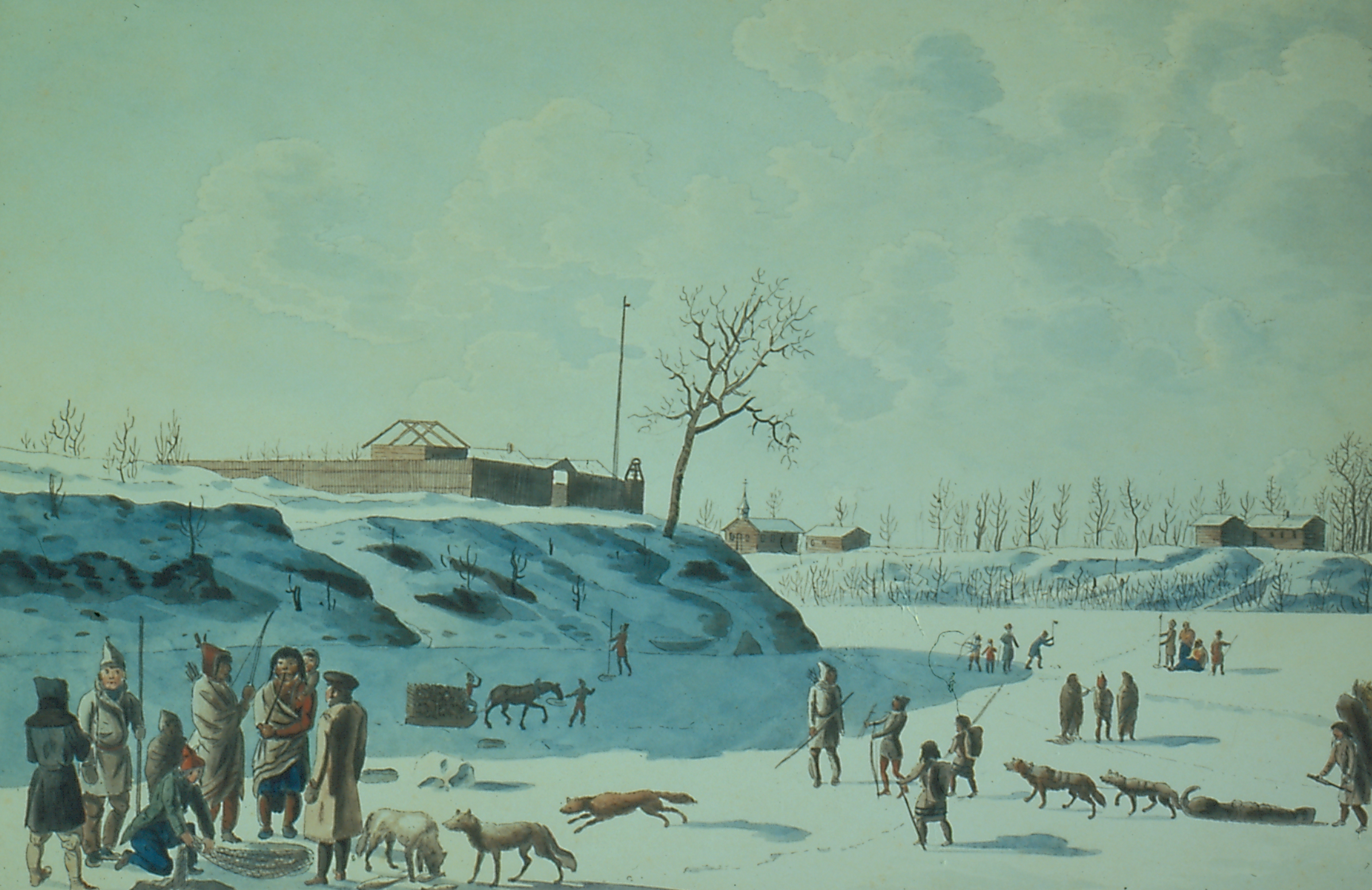
In the winter of 1822, Andrew Bulger drove his family in a horse-drawn cariole across the frozen Red River while the palisade walls of a recently renamed fort loomed behind them. That fort had already been built, burned, rebuilt, and handed from one empire to another. Fort Gibraltar, raised in 1809 by the North West Company at the junction of the Red and Assiniboine rivers, sat at the exact spot where geography forced every canoe route in the northwest to converge. Control this fork and you controlled the fur trade. The struggle over that control would produce one of the most volatile chapters in Canadian frontier history.
Two Companies, One Fork
By the early 1800s, the fur trade was Western Canada's dominant industry, and two corporate giants were locked in ruthless competition. The Hudson's Bay Company operated out of London with a distinctly English character. The North West Company, based in Montreal, drew its strength from French-Canadian voyageurs, Scottish merchants, and First Nations partners. The voyageurs were legendary travelers who paddled massive birchbark canoes across thousands of miles of waterway, and they established temporary camps at the forks of the Red and Assiniboine rivers long before anyone built permanent walls. In 1809, Alexander Macdonell of Greenfield chose this strategic confluence for the North West Company's new post. He named it Fort Gibraltar. Half a mile to the north, the Selkirk settlers and Hudson's Bay Company employees would soon raise Fort Douglas, completed in 1815. Two rival forts, barely a musket shot apart, facing each other across the frozen prairie.
Seized, Burned, Rebuilt
The proximity bred violence. The Pemmican War -- a clash over food supplies, trade routes, and territorial claims -- made the forks a battleground. On March 17, 1816, Robert Semple, the new governor of the Red River Colony, captured Fort Gibraltar and ordered it destroyed. The action was decisive but illegal. British authorities ruled against Semple, and the North West Company received permission to rebuild in 1817. The rebuilt fort would not fly its original flag for long. On March 26, 1821, the North West Company merged with its bitter rival under the Hudson's Bay Company name. Fort Gibraltar continued operations under the new standard, and by 1822 it had been renamed Fort Garry. When the catastrophic Red River flood of 1826 destroyed the structure, it was rebuilt once more and rechristened Upper Fort Garry in 1835 -- a name that would endure as the settlement around it grew into Winnipeg.
From Frontier Post to National Landmark
The site where rival fur traders once squared off was designated a National Historic Site in 1924 as part of the Forts Rouge, Garry, and Gibraltar National Historic Site of Canada. The name acknowledges all three posts that once stood within a short distance of each other at the forks, recognizing the location's layered history of trade, conflict, and eventual reconciliation under a single company. The original fort is gone, consumed by floods, fires, and the expanding city, but its footprint underlies one of Winnipeg's most visited areas -- The Forks, now a public gathering space that has drawn people for over six thousand years.
A Fort Rebuilt in Festival Spirit
In the late 1970s, a reconstructed Fort Gibraltar rose in Parc Whittier Park in St. Boniface, Winnipeg. This replica was built for the Festival du Voyageur, Western Canada's largest winter festival, which celebrates the French-Canadian and Metis heritage of the fur trade era. Every February, the fort's wooden walls enclose a world of fiddle music, jigging, bannock baking, and voyageur games. In summer, the museum runs living history demonstrations recreating daily life inside a fur trading post as it would have been in 1815 -- complete with period clothing, blacksmithing, and the cramped quarters where traders wintered through months of deep cold. Located at 866 rue St Joseph Street, the reconstructed fort stands as proof that the fur trade's most contentious crossroads can be remembered with celebration rather than conflict.
From the Air
Located at 49.89°N, 97.13°W in Winnipeg, Manitoba, at the confluence of the Red and Assiniboine rivers. The reconstructed fort sits in Parc Whittier Park in the St. Boniface neighborhood, on the east bank of the Red River. From altitude, the two rivers converging at The Forks are clearly visible, with the city grid spreading outward from the junction. Winnipeg James Armstrong Richardson International Airport (CYWG) lies approximately 7 km to the west. The flat prairie terrain makes the river confluence unmistakable from any approach direction.