Fort Harney
By January 1879, 543 prisoners huddled at Camp Harney, Bannock and Paiute men, women, and children awaiting removal to distant reservations after the last major tribal war in Oregon. A decade earlier, at this same remote outpost in the high desert, General George Crook had signed a peace treaty with Wewawewa, chief of the dominant Paiute band. The treaty promised a reservation. The reservation was created. Then white settlers grazed their cattle on tribal lands anyway, igniting the very war that filled the fort with prisoners. Today, nothing remains of Fort Harney but a small cemetery, stone markers in the sagebrush where this story played out.
Rattlesnake Camp
The Army called it Rattlesnake Camp at first, an unofficial supply drop along the creek of the same name in what is now Harney County. As wagon trains increased through eastern Oregon and miners flooded the backcountry, the demand for military protection grew. Rattlesnake Creek sat near the geographic center of eastern Oregon, an ideal location for a headquarters. On August 16, 1867, the Army established a permanent outpost near the creek's mouth. They named it Camp Steele, but Major General Henry W. Halleck, commander of the Military Department of the Pacific, had other ideas. He suggested honoring Brigadier General William S. Harney, who had commanded the Department of Oregon in 1858 and 1859. By September 14, 1867, the post was officially Camp Harney.
Enemies as Scouts
General Crook's campaign against the Northern Paiute from 1867 to 1868 deployed an unlikely force. Companies from the 1st and 8th Cavalry Regiments, mounted infantry from the 9th and 23rd Infantry Regiments, and scouts from the Wasco and Warm Springs tribes, peoples who had fought the Paiute for generations. Camp Harney resupplied these columns as they pursued bands across eastern Oregon and into northern California in the conflict known as the Snake War. The campaign succeeded. In 1869, Crook and Wewawewa signed a treaty at Fort Harney ending the raids. The Paiutes agreed to settle on a reservation north of Malheur Lake. Camp Harney sat within those boundaries, Army soldiers assigned to keep white trespassers out and Paiutes in.
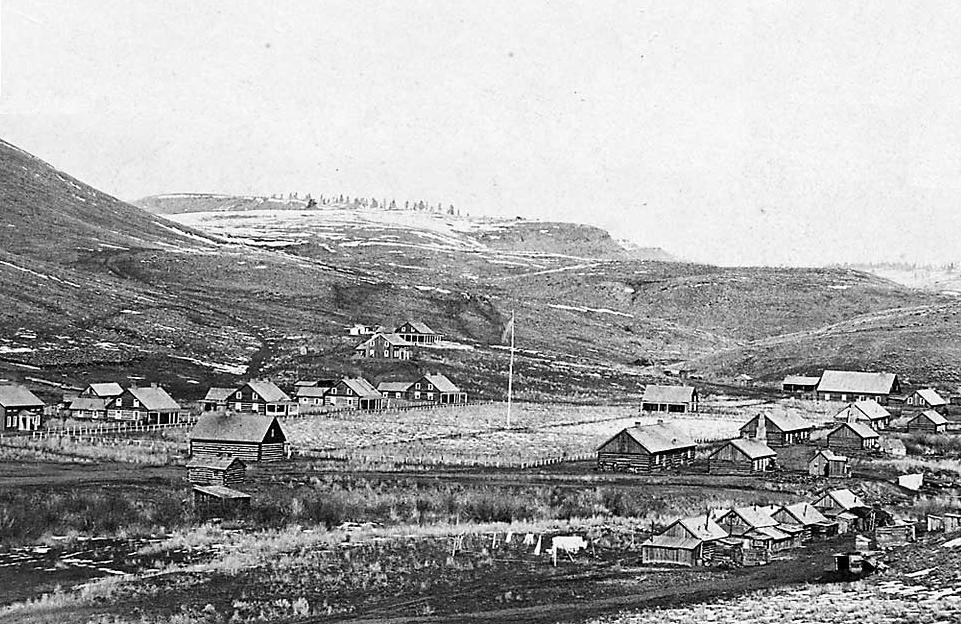
A Town in the Wilderness
By 1877, Camp Harney had grown into a proper frontier town. A large parade ground ran north to south, flanked by a headquarters building and guardhouses. The commanding officer had his own home, five additional officers' quarters stood nearby, two of logs, three of frame construction. Three log barracks housed enlisted men, four more log buildings sheltered soldiers with families. To feed this population, the camp maintained mess halls, kitchens, a bakery, and a slaughterhouse. Quartermaster's storehouses and a military commissary supplied everything from ammunition to flour. A hospital treated the sick and injured. A sawmill cut timber from the pine stands north of the camp. A blacksmith shop and stables for 150 horses kept the cavalry mobile. Four civilian clerks, two masons, a saddlemaker, shoemaker, painter, baker, and four laundry maids completed the community.
The War That Shouldn't Have Been
The Paiutes kept the peace. The settlers did not. Despite the Army's presence, ranchers grazed cattle on reservation land throughout the 1870s. This unchecked encroachment helped spark the Bannock War of 1878. Newspapers reported Camp Harney in imminent danger of being overrun. They exaggerated, but the camp did return to its wartime role as supply depot and military headquarters, positioned at the center of the conflict zone. General Oliver O. Howard defeated the Bannocks and Paiutes within months. The prisoners that followed, those 543 souls held through the winter of 1878-79, would be scattered to reservations across the West. The fort lingered until 1880, then closed. The high desert slowly reclaimed its buildings. Today, only gravestones mark where Fort Harney once stood.
From the Air
Located at 43.67N, 118.81W in Harney County, Oregon, approximately 18 miles east of Burns. The site lies in high desert terrain at an elevation of roughly 4,200 feet, on a flat west of Rattlesnake Creek between steep ridges. Nothing remains visible except a small cemetery. Nearest airport is Burns Municipal (KBNO) 18nm west. The ghost town of Harney City lies 2 miles south of the fort site along a gravel road north of US Highway 20. Best viewed at lower altitudes to spot the creek drainage and ridge formations that dictated the fort's layout.