Fort Harssens
In September 1885, the artillery officers at Den Helder fully loaded their new Krupp guns for the first time and fired. Hundreds of windows broke across the town. Politicians filed compensation requests. The shock wave rolled out across the Nieuwediep and rattled steamboats as far as Terschelling, where startled crews assumed a ship was in distress. The guns belonged to Fort Harssens, a brick-and-iron fortress crouched on a shoal at the edge of the naval base, designed for one job: keep enemy battleships far enough offshore that they could not hit anything that mattered. To do that, it needed the heaviest naval cannon Krupp could sell.
Napoleon Picked the Spot
The site only existed because of a French emperor. In 1811 Napoleon visited Den Helder, looked across the Marsdiep at the Texel anchorage, and saw what every Dutch admiral before him had also seen - that this stretch of coast was the lock on Amsterdam's back door. He ordered fortifications, a naval base at Willemsoord, and the network of works that became the Stelling Den Helder. Earlier proposals had imagined dropping a fortress straight into the water near the channel, manned by 500 men and bristling with 80 guns. The water-fort never happened. But the idea of armed islands defending the deep-water anchorage took hold, and Fort Harssens, completed seventy years after Napoleon's visit, was its descendant - a hardened gun platform on a shoal on the east bank of the Nieuwediep.
Why Two Cupolas, and Why Krupp
By the 1860s the Dutch had watched the Battle of Hampton Roads transform naval warfare. Wooden hulls were obsolete; armoured ships ruled the coastal approaches. Coastal forts now needed to penetrate iron plating at long range, and the Minister of War, Jacobus den Beer Poortugael, argued for the heaviest guns available. The Krupp 30.5 cm MRK L/25, his ministry calculated, could punch through a 40-centimetre armour plate at 2,900 metres. A lighter 28-centimetre weapon could only manage 1,700 metres. The difference mattered, because it determined how close an enemy battleship could approach before becoming dangerous. In 1879 the Dutch parliament approved 300,000 guilders for Fort Harssens; by November 1881 the projected total had climbed to 1,455,160 guilders. The plan called for two armoured cupolas, each housing two of the Krupp guns - four heavy barrels in total, rotating to track ships in the Marsdiep. The cupolas themselves came from Gruson in Magdeburg, hauled across the water on a special rail-equipped barge.
The Test That Almost Killed the Concept
On 22 October 1883 the Dutch ordered a real-world test of Gruson's chilled-iron armour against the Krupp guns they had just bought. The German artillery test commission attended. So did Henri Alexis Brialmont, the famed Belgian fortification engineer, and the ambassadors of Japan and China. The target was a mock-up cupola of three different armour plate types. The 'front plate', a fixed shield 1,060 millimetres thick, was hit four times from twenty-seven metres. On the fourth shot it cracked, and fragments fell inside. The side plates failed similarly. Only a separate test in May 1884, against the top plate, gave the cupola a passing grade. Experts argued about what the results meant. Some declared Gruson's chilled-iron armour obsolete now that Krupp had switched to steel grenades; others noted that the first three rounds had not penetrated. The Dutch commission concluded that the front plates needed redesign and better support. Gruson improved the plates. The fortress was built anyway. Whether the armour would have held against an actual battleship's main guns in a real engagement was a question that never had to be answered.
Obsolete by 1906, Still Standing in 2026
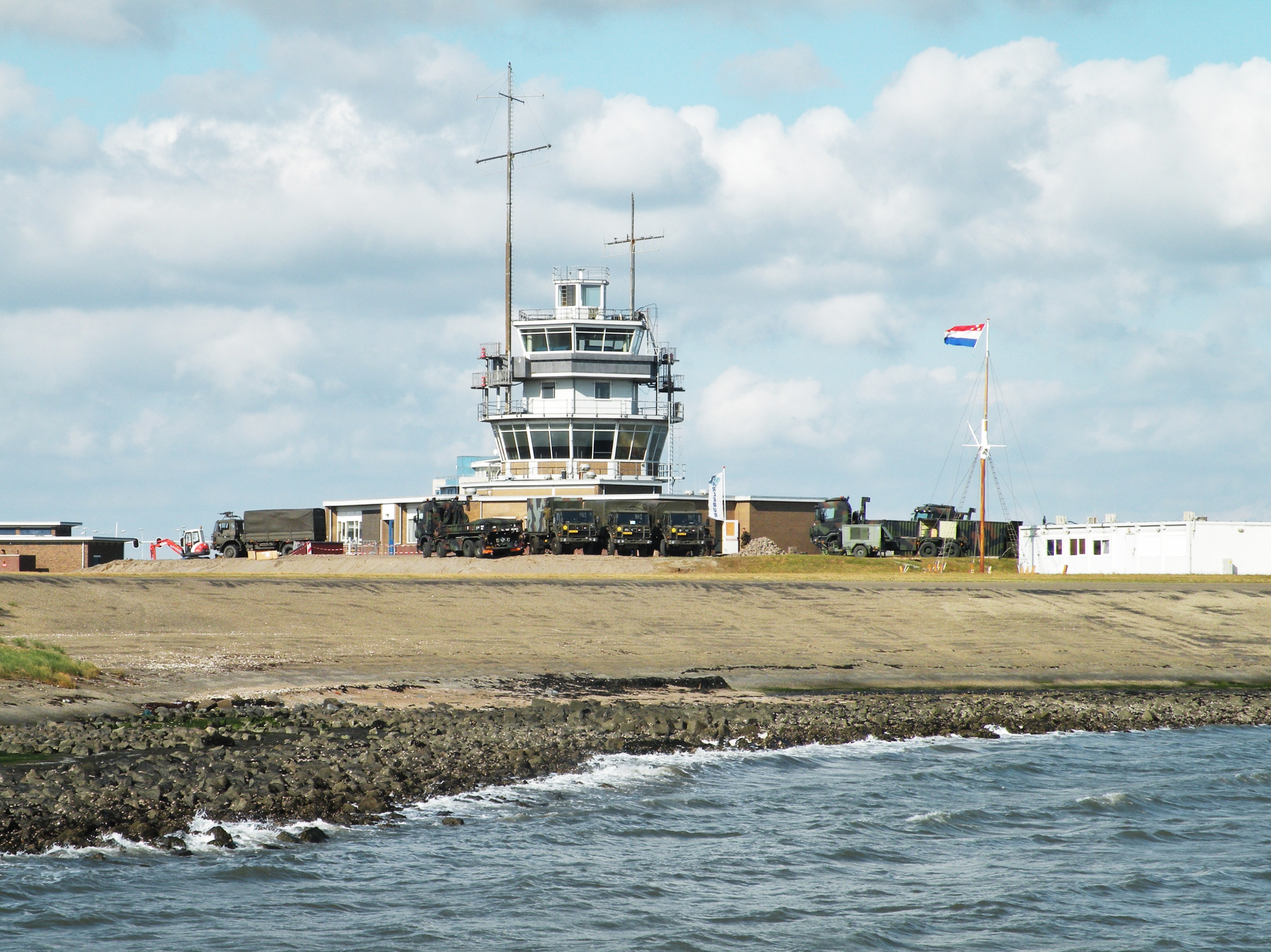
By 1906 naval guns and battleship armour had moved past anything Fort Harssens could threaten. The 30.5 cm Krupps were still serious weapons in theory, but the rest of the Stelling Den Helder - with its 24 cm guns from the 1870s - was, in honest assessment, useless against modern capital ships. The Dutch government economised through the interwar period. Around 1930 the big guns at Harssens were quietly relinquished from service. In May 1940, when German forces took the fortress, they dismantled the guns and cupolas to melt down the metal. The fort kept its bones. In 1952 the Royal Netherlands Navy built an office on top of the structure, filled in the dry moats, and effectively buried Harssens under its own future. The buildings of the Nieuwe Haven grew up around it. Then in 2009 the navy excavated one of the dry moats to see what remained. On 12 July 2011, a new Vessel Traffic Control Centre - the Haven Coördinatie Centrum Den Helder - was opened above the fortress, controlling military and civilian shipping into the base. A serious renovation began in 2016. The fortress, the office, and the traffic centre now form a layered single building on Harssens shoal.
Visiting and Viewing
Fort Harssens is still military terrain - it sits inside the working naval base - but the Stichting Stelling Den Helder runs guided tours. The first Pantserfort Compagnie that manned the cupolas was founded on 1 May 1886. Today the fortress is a museum stop on the network of preserved Dutch coastal works that also includes Fort Erfprins, Fort Kijkduin, and Fort Westoever. From the air the structure is largely invisible - swallowed by the harbour buildings and the modern traffic tower - but the geometry of the old moats can still be traced in satellite views, and the wide flat shoal of Harssens still angles into the Nieuwediep just where Napoleon's engineers said the British, the Spanish, or anyone else trying to reach Amsterdam from the sea would have to come.
From the Air
Coordinates: 52.9641°N, 4.7816°E. Located on the Harssens shoal on the east bank of the Nieuwediep, inside the Den Helder naval base in North Holland. Active military terrain - overflight subject to restrictions; check NOTAMs and military airspace status. Nearest airport: De Kooy heliport (EHKD) about 2 km southwest. Schiphol (EHAM) about 65 km south. The Marsdiep channel and the Texel ferry route are immediately to the north.