Fort Lennox
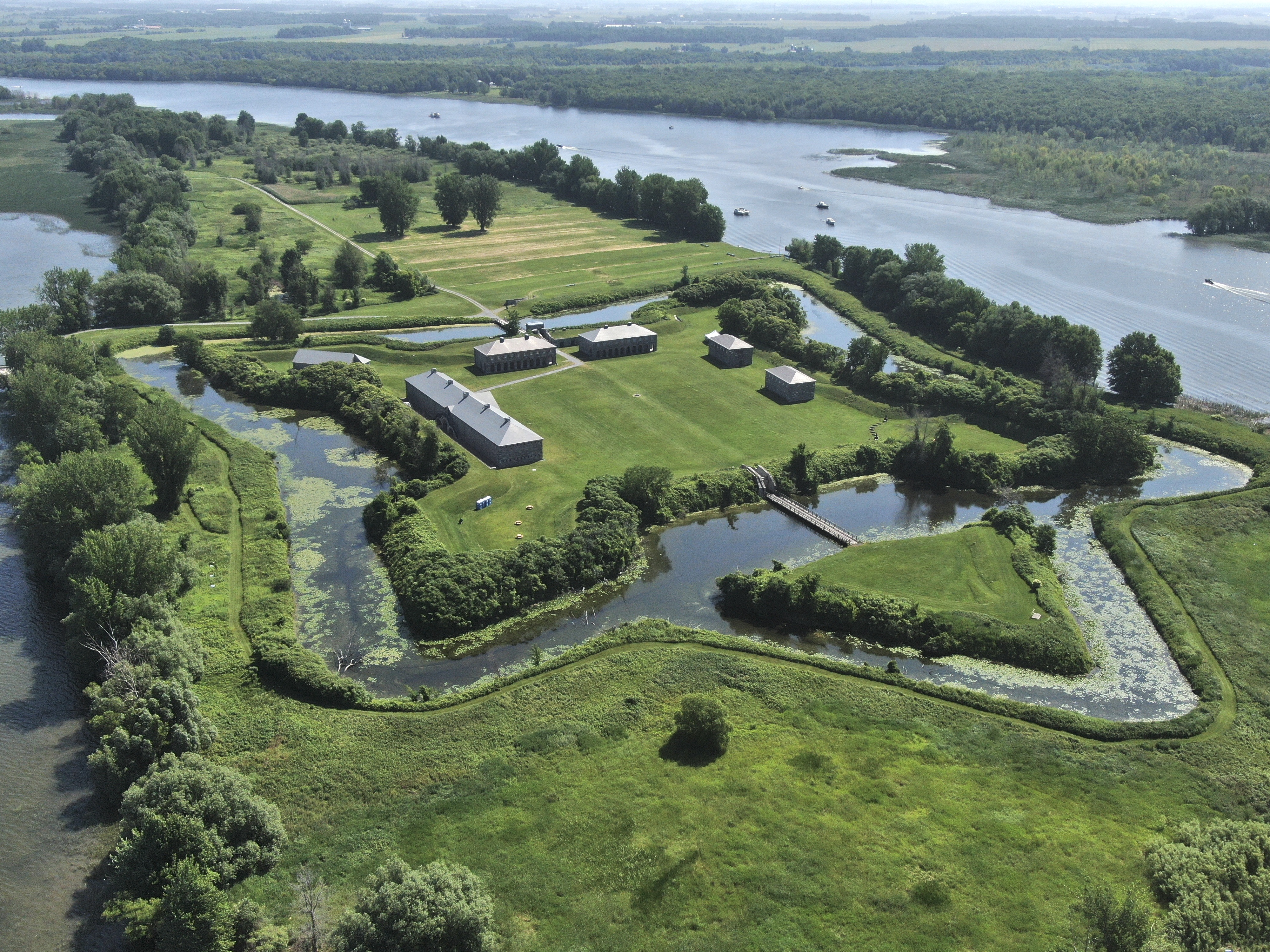
From the air, it looks like a geometric puzzle dropped into the middle of a river -- a perfect star-shaped moat surrounding stone ramparts on a small island, the dark waters of the Richelieu flowing past on all sides. This is Fort Lennox, a National Historic Site of Canada that occupies most of Ile aux Noix, a strategic island that has been fortified, fought over, and rebuilt for nearly three centuries. The fort sits in the parish of Saint-Paul-de-l'Ile-aux-Noix, Quebec, just a few kilometers from the Canada-United States border, exactly where generations of military planners expected trouble to come from.
The Invasion Corridor
The Richelieu River flows north from Lake Champlain to the St. Lawrence, and for centuries it served as the most direct water route between Montreal and New York. Any army marching north from the American colonies -- whether British, American, or potentially hostile -- would travel this corridor. Ile aux Noix sits in the middle of that river like a cork in a bottle. The French recognized this in 1759, during the final desperate years of the Seven Years' War, and built the island's first fortifications to block the advancing British. It did not save New France, but the logic of the location endured. Whoever held this island controlled the river, and whoever controlled the river held the key to Montreal.
Built for a War That Never Came
The fort visible today is not the French original but a British construction, built between 1819 and 1829 in the aftermath of the War of 1812. The conflict had exposed how vulnerable British North America remained to American invasion, and the Crown invested heavily in defensive infrastructure. Fort Lennox was designed to stop any repeat of the American incursions that had threatened Montreal during that war. Named after Charles Lennox, the 4th Duke of Richmond, who served as Governor General of British North America and died in 1819, the fort was constructed with thick stone walls, ordnance and artillery magazines, a guardhouse, officers' quarters, barracks, and casemates. The star-shaped moat surrounding the entire complex made the island essentially impregnable to a direct assault. Yet the anticipated American invasion never materialized. The border between Canada and the United States gradually settled into the peaceful line it remains today, and Fort Lennox's cannons never fired in anger.
Garrison Life on the Island
Despite never seeing combat, Fort Lennox was a functioning military post for decades. Soldiers of the British garrison lived and drilled on this small island, their world bounded by the river and the star-shaped walls. The officers' quarters, which visitors can still tour, reflect the hierarchies of 1820s military life -- comfortable rooms for the officers, spartan dormitories for the enlisted men. The barracks, the guardhouse, the powder magazines -- each building served a precise function in the daily rhythm of garrison duty. During summer weekends today, Parks Canada stages living history demonstrations that bring this mid-19th century routine back to life, with interpreters donning the uniform of the 24th British Infantry Regiment and demonstrating the drills, discipline, and daily grind that defined a soldier's existence at this remote river outpost.
Passages Through Time
Fort Lennox closed for extensive renovations and reopened to the public in spring 2023 with a new exhibition called Passages, Experiences of this Island. Spread across twelve alcoves in the newly restored barracks, the exhibit traces the many different groups who passed through Ile aux Noix -- French soldiers, British regulars, American invaders, and the generations of Canadians who eventually inherited this remarkable place. The fort was designated a National Historic Site of Canada in 1920, recognizing its importance to the country's military and colonial heritage. In 1985, Canada Post honored it with a stamp in the Forts Across Canada Series, designed by Rolf P. Harder. To reach the fort today, visitors take a short ferry from the parking lot and visitor center on the river's west shore -- a fitting arrival for a place whose entire identity is shaped by the water that surrounds it.
The Star in the River
Seen from above, Fort Lennox's geometry is striking. The star-shaped moat and angled bastions follow the principles of European fortress design perfected in the 17th and 18th centuries, where every wall angle was calculated to eliminate blind spots and allow defenders to lay down overlapping fields of fire. That this sophisticated military architecture sits on a wooded island in a quiet Quebec river, surrounded by farmland and the gentle landscape of the Monteregie, gives it an almost surreal quality. The fort stands as a monument to a time when this peaceful border was anything but, when the Richelieu was not a scenic waterway but a highway for armies, and when the fate of nations could hinge on who held a small island in the middle of a river.
From the Air
Located at 45.12N, 73.27W on Ile aux Noix in the Richelieu River, just north of the Canada-US border. The star-shaped fort and moat are clearly visible from low altitude. The Richelieu River runs north-south, connecting Lake Champlain to the St. Lawrence. Nearby airports include Montreal-Saint-Hubert (CYHU) approximately 45 km northwest and Plattsburgh International (KPBG) roughly 40 km south across the border. Best viewed at 2,000-3,000 feet AGL to appreciate the star geometry.