Fort Livingston
Before the U.S. government built a fort on Grand Terre Island, it first had to evict the pirates. Captain Jean Lafitte had been running his smuggling and privateering operation from this low-lying barrier island at the mouth of Barataria Pass since the early 1800s, using it as a staging ground for contraband flowing into New Orleans. The Navy forced Lafitte out in 1814, and within two decades the government began constructing a coastal defense fort on the same ground. That fort -- named for Edward Livingston, who served as both a U.S. Senator from Louisiana and Secretary of State under Andrew Jackson -- was never finished. Construction halted when the Civil War began, and no one ever came back to complete the job. Today Fort Livingston stands in ruins on an island reachable only by boat, slowly losing ground to the Gulf that surrounds it.
From Pirate Haven to Sugar Fields to Fortress
Grand Terre Island passed through remarkably different hands in a short span of years. After Lafitte's expulsion, the island was purchased by Jean Baptiste Moussier, who ran it as a sugar plantation from 1821 until his death in 1831. The U.S. government then acquired a tract on the island's west end from Moussier's creditor, Etienne De Gruy, and broke ground on construction in 1834. Work stopped almost immediately that same year, and did not resume until 1840. The fort itself began rising in 1841 under the direction of Major P.G.T. Beauregard -- who would later become one of the most prominent Confederate generals of the Civil War. A lighthouse was added near the fort in 1856, but by the time war broke out in 1861, Fort Livingston remained unfinished.
A Fort That Never Fired a Shot
The Confederacy garrisoned Fort Livingston early in the Civil War, stationing four companies totaling 300 men under General Lovell. They armed it with 15 guns: a 32-pounder, an 8-inch columbiad, seven 24-pounders, four 12-pounders, and two howitzers. The fort's strategic purpose was to protect blockade runners slipping through Barataria Pass on their way to and from New Orleans. Yet for all its armament, Fort Livingston never saw combat. The garrison eventually withdrew, and the fort passed the remainder of the war in silence. After the conflict, the U.S. Army left a single Ordnance Sergeant to mind the crumbling property beginning in 1866. A hurricane destroyed most of the structure in 1872, and the fort was permanently abandoned. The last ammunition was removed on February 16, 1889.
Shrimp, Science, and Storms
The island's postmilitary history is as layered as its past. In 1867, a commercial shrimp cannery opened adjacent to the fort ruins -- a facility that produced the first canning of shrimp in America. The U.S. government transferred control of both the fort and the island to the State of Louisiana in 1923, and Grand Terre was designated a state Wildlife and Fisheries reservation in 1955. The island became home to the Louisiana Department of Wildlife and Fisheries' Marine Laboratory, which operated there until Hurricane Gustav destroyed it in 2008. Fort Livingston was listed on the National Register of Historic Places in 1974, and the Louisiana legislature created the Fort Livingston State Commemorative Area in 1979.
The Gulf Closes In
Fort Livingston is Louisiana's only fort on the Gulf of Mexico, and the Gulf is slowly reclaiming it. Tropical storm systems in 2002 dramatically accelerated erosion along West Grand Terre Island, forcing the Louisiana Department of Natural Resources to construct a rock dike to protect the fort and conserve the shoreline. The ruins remain accessible only by boat and are closely monitored by the U.S. Coast Guard, whose station sits directly across Barataria Bay on Grand Isle. Visitors who make the crossing find a classic example of early 19th-century American coastal fortification -- thick masonry walls open to the sky, overgrown with salt-tolerant vegetation, battered by wind and tide. It is a place that has outlasted pirates, planters, soldiers, and cannery workers, but whether it can outlast the rising waters is another question entirely.
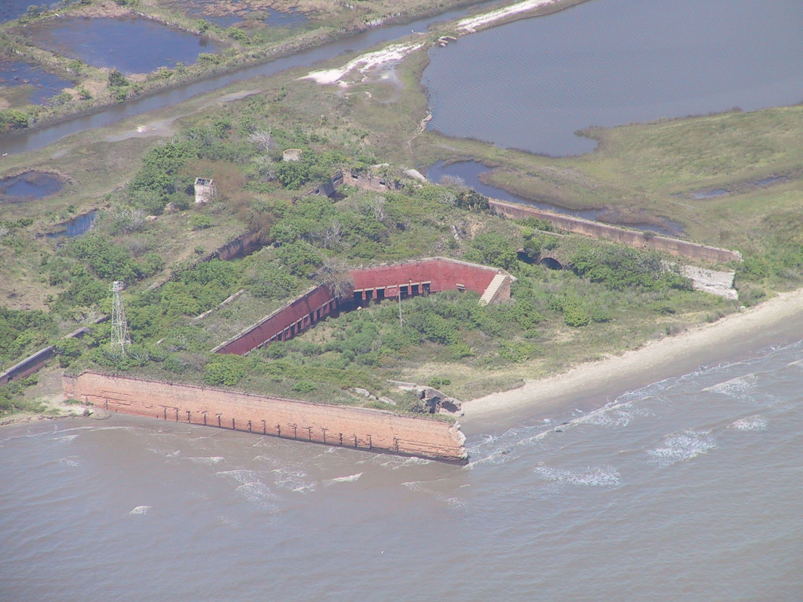
From the Air
Located at 29.27N, 89.95W on Grand Terre Island at the mouth of Barataria Pass, Jefferson Parish, Louisiana. The fort ruins are visible from low altitude on the western end of the island. Grand Isle and its Coast Guard station lie directly to the west across the pass. Nearest airport: Grand Isle Airport (unattended) approximately 3nm west; Louis Armstrong New Orleans International (KMSY) approximately 55nm north-northwest. The barrier island chain is a prominent visual feature -- look for the narrow strips of land separating Barataria Bay from the Gulf of Mexico. Water on all sides; sea-level terrain. Expect coastal haze and potential for convective weather, especially in summer.