Fort Mackinac
A British cannonball solved Lieutenant Porter Hanks's legal problems in the most permanent way imaginable. Hanks had surrendered Fort Mackinac to a combined British and Native American force on July 17, 1812 - before he even knew war had been declared. Charged with cowardice upon reaching Detroit, he awaited court-martial. But before proceedings could begin, British forces attacked Fort Detroit, and a cannonball ripped through the room where Hanks stood, killing him instantly along with the officer beside him. It was the kind of grim irony that defined Fort Mackinac across its 115 years of military service: a place where the stakes were always high, the garrison always too small, and fate always had the last word.
The Fort Nobody Knew They'd Lost
Fort Mackinac began as a British stronghold, built in 1780 on limestone bluffs 150 feet above the Straits of Mackinac. The British had moved their garrison here from the mainland fort at Michilimackinac, seeking a position that was more defensible. Despite the Treaty of Paris ending the American Revolution in 1783, Britain refused to hand over the fort until the Jay Treaty was ratified in 1796. When the War of 1812 erupted, Major General Isaac Brock moved fast: he dispatched orders to Fort St. Joseph, and on July 17, 1812, Captain Charles Roberts landed on the island's north end with about 200 soldiers and Canadians plus several hundred Native American warriors. Roberts dragged two 6-pounder cannons to the high ridge overlooking the fort and trained them on the garrison below. Lieutenant Hanks, with only 60 men and no word from his superiors for months, surrendered without a fight. Two American supply ships from Fort Dearborn in Chicago arrived shortly after, unaware of either the war or the surrender. The British raised the American flag as a ruse, and captured both vessels when they tied up at the pier.
The Window Into a Living Stomach
Fort Mackinac's most extraordinary chapter had nothing to do with combat. On June 6, 1822, a fur trader named Alexis St. Martin was waiting to trade his pelts when a gun accidentally discharged inches from his abdomen, blowing a hole through his stomach wall. The post surgeon, Dr. William Beaumont, treated what seemed a fatal wound. Against all expectations, St. Martin survived - but his stomach never fully closed. A permanent opening, or fistula, remained. Beaumont recognized a once-in-history opportunity. He took St. Martin into his home, cared for him for several years, and began conducting experiments through the opening - observing digestion in real time, testing how different foods broke down, measuring the stomach's temperature and acid content. Beaumont's published findings described the process of human digestion in unprecedented detail. He became known as 'The Father of Gastric Physiology,' and the accidental wound of a fur trader at a remote frontier post became one of the most important medical discoveries of the 19th century.
Explorers, Agents, and a President's Brother
Between wars, Fort Mackinac served as a staging area for American expansion into the northern wilderness. The expedition of 1820 under Lewis Cass departed from here to explore the headwaters of the Mississippi River. Henry Rowe Schoolcraft served as U.S. Indian agent at the fort in the 1830s, conducting extensive studies of Native American languages and culture - work aided by his marriage to Jane Johnston, the Ojibwe-British daughter of a wealthy Sault Ste. Marie fur trader. From 1816 to 1821, the post was commanded by Benjamin Kendrick Pierce, the older brother of future President Franklin Pierce. Pierce married the daughter of Magdelaine Laframboise, a prominent fur trader of Odawa and French descent, connecting the fort's military establishment to the mixed Indigenous and European culture that defined the Great Lakes frontier. The fort was never merely a military installation; it was a crossroads where cultures, commerce, and ambition converged.
Confederate Prisoners and a Long Winter
Fort Mackinac saw its oddest chapter during the Civil War. The Army had largely emptied the garrison, leaving an ordnance sergeant as its lone caretaker during stretches of both the Mexican-American War and the Civil War. But in the summer months, three Confederate political prisoners were shipped to the island. Their confinement was remarkably relaxed - guarded by volunteer militia, the prisoners enjoyed relative freedom on the small island. The arrangement worked fine through the warm months. Then autumn arrived, and the prospect of a long, brutal northern Michigan winter in an island fort with no escape loomed. Two of the three Confederates signed loyalty oaths and were released. The third refused, and the Army eventually transferred him to another post. The fort's final military distinction came in 1875 when it was incorporated into Mackinac National Park - the second national park in the United States, after Yellowstone. For twenty years, soldiers served as park caretakers, drilling on the parade ground and maintaining what had become more of a scenic post than a strategic one.
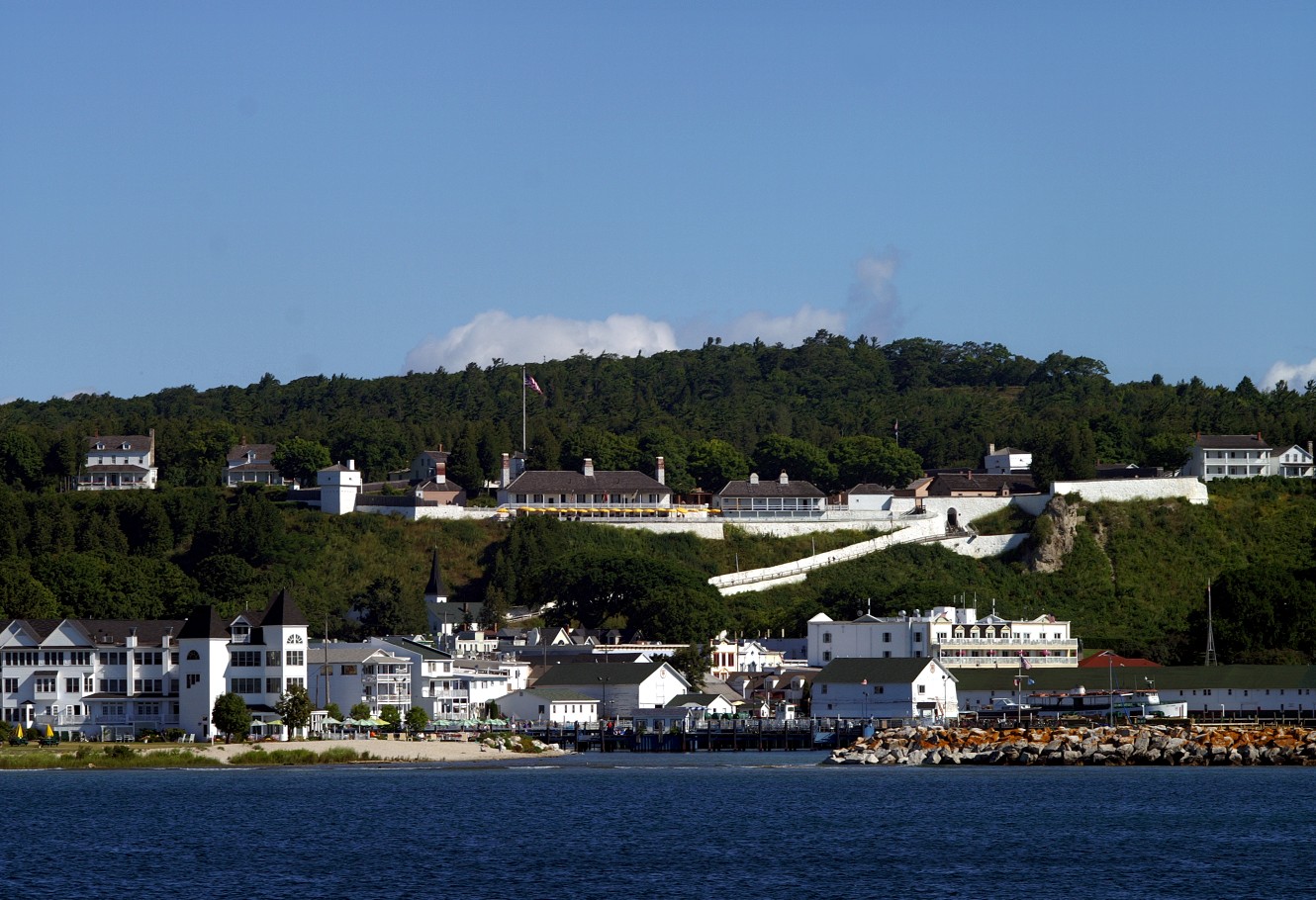
Stone Walls and Living History
In 1895, Congress closed Fort Mackinac and transferred it to the State of Michigan, creating Mackinac Island State Park - Michigan's first state park. The Mackinac Island State Park Commission pioneered a financial model borrowed from the Mackinac Bridge: rather than depending on public subsidies, the commission funds more than three-quarters of its budget through admission fees and self-generated revenue. Today, the fort's 14 original buildings stand as one of the most complete early American forts in the country. The Officer's Stone Quarters, dating to 1780, is Michigan's oldest building. Costumed interpreters portray life in the 1880s, firing the 1841-model six-pounder cannon multiple times daily - the second-largest cannon regularly demonstrated on the Great Lakes. Visitors can explore the soldiers' barracks, the post hospital where surgeons once treated frontier ailments, and the guardhouse with its prison cell in the back. From the ramparts, 150 feet above the Straits of Mackinac, the view stretches across the same waters that carried British war canoes, American warships, and fur-laden bateaux for more than a century.
From the Air
Located at 45.85°N, 84.62°W on the southern bluffs of Mackinac Island, overlooking the Straits of Mackinac. The fort's white stone walls are visible on the limestone bluffs above the harbor. Fort Holmes (the former Fort George) sits on the higher ridge to the north. The Mackinac Bridge is visible about 5 miles to the southwest. Nearest airports: Mackinac Island Airport (MCD) on the island, Pellston Regional Airport (PLN) approximately 12 miles south. From 1,500-2,500 feet, the fort's position commanding the harbor and straits is immediately apparent - the strategic logic of its placement reads clearly from the air.