Fort Mahon
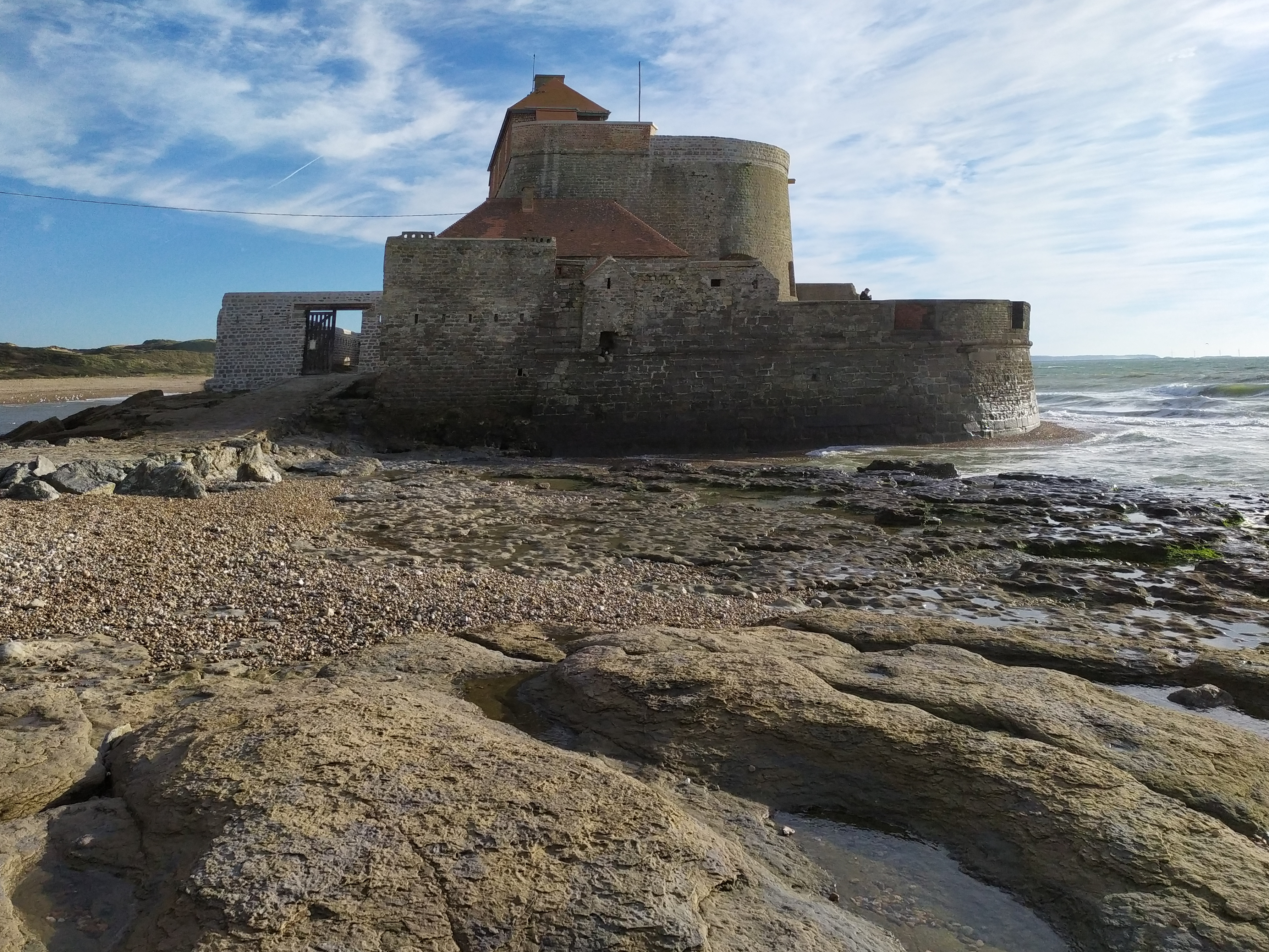
The fort is not actually called Fort Mahon. Its real name, written into every official French document since the Napoleonic cadastre of 1803, is Fort d'Ambleteuse - named for the village a short walk inland from the dunes where it stands. "Fort Mahon" first appears in English-language texts around 1840 and is almost certainly the result of someone, somewhere, copying down the wrong word and never being corrected. The misnomer stuck. It is now what English speakers call this squat granite bastion at the mouth of the river Slack, and it is what the locals patiently explain it is not, every weekend from April to November, when visitors climb the spiral stairs to the viewing platform on top.
Vauban's Tide Trick
Work on the fort was completed in 1690, ordered by Louis XIV and designed by Sebastien Le Prestre de Vauban - the architect-engineer whose star forts and sieges defined the late seventeenth century. Vauban's signature move here was the site itself. He placed the fort where the Slack empties into the English Channel, on a patch of foreshore that can only be reached on foot at low tide. At high water it becomes an island. Inside the stone-lined bastion, five-piece coastal artillery faced seaward through embrasures cut into walls up to three meters thick. An outer sea wall sheltered the gun terrace from breaking waves. On the landward side Vauban added a small parade ground and a barracks for the garrison, with musket-slits for close defense. Approach by land meant crossing wet sand within range of the guns; approach by sea meant approaching guns that could not be silenced by the surf.
The Atlantic Wall
The fort was still standing when German troops occupied this stretch of the Pas-de-Calais in the Second World War. They incorporated it into their coastal defenses. The open gun platform inside the bastion, untouched since the 1680s, was divided in two by a concrete partition. A pillbox sprouted on the landward side. Vauban's seventeenth-century geometry was overlaid with the brutal angles of twentieth-century war. Inside the walls, the Germans imprisoned foreign forced laborers - the men they had conscripted from across occupied Europe to build the fortifications a few miles up and down the coast. The Frank Falla Archive in Britain still records the names of Channel Islanders held here against their will. When the war ended, two sea mines went off near the fort in 1945, blowing apart the outer defenses that had stood for two and a half centuries.
Bought for One Franc
By the 1960s the fort was a ruin, slated for the indifferent decay that finished off most of the coastal defenses between Cherbourg and the Belgian border. A physician named Dr. Jacques Méreau and a geologist named Destombes saw something the bureaucrats had missed. In 1967 they assembled a team of volunteers, and their newly formed Association des Amis du Fort d'Ambleteuse bought the entire fort from the French government for a single symbolic franc. Restoration came in three campaigns: first the ramparts, then the ancillary buildings, then in 2010 a complete re-roofing funded by the state and heritage organizations including the Fondation du patrimoine, France's equivalent of the National Trust. The wall destroyed by the 1945 mines was rebuilt with its original battlements. The result is the only complete coastal fort still standing on the entire coastline from Cherbourg to Belgium.
What You See From the Top
Climb to the viewing platform on a clear Sunday afternoon and the interpretation board does most of the work for you. North-east, twenty miles across the Strait of Dover, the white cliffs of England rise out of the water - close enough on a good day to count the wind turbines turning above the chalk. Below you, the river Slack pools across the sand at low tide, dotted with the dark hulls of beached fishing boats. The dunes of the Cote d'Opale stretch in both directions, broken by villages that were heavily bombed during Operation Cockade in 1943. Behind the fort, in Bewdley, Worcestershire, there is a street called Fort Mahon Place named for this very building - one of those small ribbons of memory that thread back across the Channel, joining the coast where England once landed armies to the towns it sent men home to.
From the Air
Located at 50.81 degrees North, 1.60 degrees East, on the Pas-de-Calais coast just south of Cap Gris-Nez. The fort sits on the foreshore at the mouth of the river Slack, isolated at high tide. Cruise 1,500 to 4,000 feet for clear sight of the fort and the dunes flanking it. Nearest airfields: Calais-Dunkerque (LFAC) 30 km north-east, Le Touquet (LFAT) 40 km south. The Strait of Dover is heavily trafficked; expect significant maritime activity. Crosswind from the Channel is the rule, not the exception.