Fort Mangochi
On October 28, 1895, Major Edwards walked into a village that should have held 25,000 people. It was empty. The Yao who had lived on this mountain plateau for generations had fled before the advancing British-led force, abandoning the settlement their chief Jalasi had defended for years. Within months, fired-brick walls would rise on the same ground where Yao families had built their homes, and the place would be renamed in the language of its conquerors. Fort Mangochi, perched between 4,200 and 4,500 feet in the mountains of southeastern Malawi, preserves both stories in its crumbling walls.
The Chief Who Fought Back
Chief Jalasi, also known as Zarafi, was one of several powerful Yao leaders who controlled the highlands near Lake Malawi in the late nineteenth century. Along with chiefs Mponda and Makanjila, he profited from the East African slave trade, which had devastated the region for decades. When the British declared their Central Africa Protectorate in 1891, these chiefs had every reason to resist -- the British explicitly intended to suppress the slave trade that underpinned Yao power. Jalasi fought off the initial British incursion that year, holding his ground on the mountain plateau. But the 1895 assault, carried out by a diverse colonial force of Indian Sikh soldiers alongside Makua, Atonga, and Yao men enlisted by the British, proved overwhelming. Jalasi fled across the border into Portuguese-ruled Mozambique, where he died in 1906. Many of his people eventually returned to the area.
Bricks on the Bones of a Village
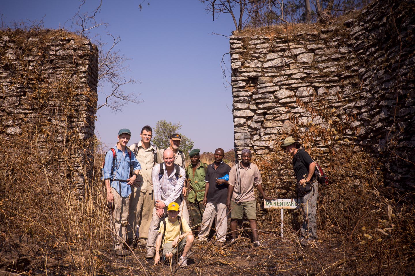
Lieutenant E. G. Alston received the commission to build a permanent fortress on the conquered plateau. The name itself -- Mangochi -- derives from the Yao word "magoji," referring to a local tree whose bark was used as rope for tying. The fort that rose on this site was substantial: thick rock walls several feet across and two to three meters high enclosed a complex of fired-brick buildings. Sign posts still mark the guardroom and armory, the district commissioner's quarters, servants' quarters, a flag post, a parade ground, and an Indian hospital -- the last a reminder that Sikh soldiers from British India garrisoned this remote African outpost. A gun sight still peers out from the walls, aimed at an approach route that no enemy ever used again. Below and to the north, Mangochi mountain climbs to its 5,713-foot peak, the fort nestled in its shoulder like a sentry refusing to leave its post.
A Fort's Second Life
After the frontier pacification that justified its construction, Fort Mangochi found new purposes. From 1907 to 1910, it served as a prison -- the thick walls and remote location making it as effective at keeping people in as it once was at keeping them out. When World War I reached East Africa, the King's African Rifles used the fort as a training camp, preparing soldiers for a theater of war that most histories overlook. German forces in neighboring Tanganyika and Portuguese Mozambique made this region strategically relevant, and the mountain fortress suddenly had military utility again. After the war, the fort gradually fell into disuse, its buildings surrendering to weather and vegetation while the district's administrative center shifted to more accessible locations in the lowlands.
Walking the Ruins Today
Visitors who make the journey to Fort Mangochi near the town of Namwera find a site caught between preservation and neglect. The walled compound remains largely intact, its rock construction more durable than the tropical rains that have erased lesser structures across Malawi. Inside, the fired-brick buildings stand roofless but recognizable, their labeled sign posts offering a guided tour of colonial administration frozen in time. A dam outside the fort walls hints at the infrastructure required to sustain a garrison on a mountaintop. The surrounding landscape is striking -- the high plateau ringed by mountains, the air cooler than the lowlands around Lake Malawi to the east. Below, the descendants of the Yao people whom Jalasi once led continue to live in the Mangochi District, their history layered into the same ground where the fort's walls stand. The ruins hold the memory of both the displaced and the displacing, asking visitors to reckon with both.
From the Air
Located at 14.35S, 35.48E in the mountains of Mangochi District, southeastern Malawi. The fort sits on a plateau between 4,200 and 4,500 feet elevation, just north of Mangochi mountain's 5,713-foot peak. Nearest significant airfield is Mangochi (no ICAO code assigned). Chileka International Airport (FWCL) near Blantyre is approximately 200 km to the southwest. The mountainous terrain and plateau are visible from altitude in clear weather. Lake Malawi lies to the east.