Fort Massachusetts
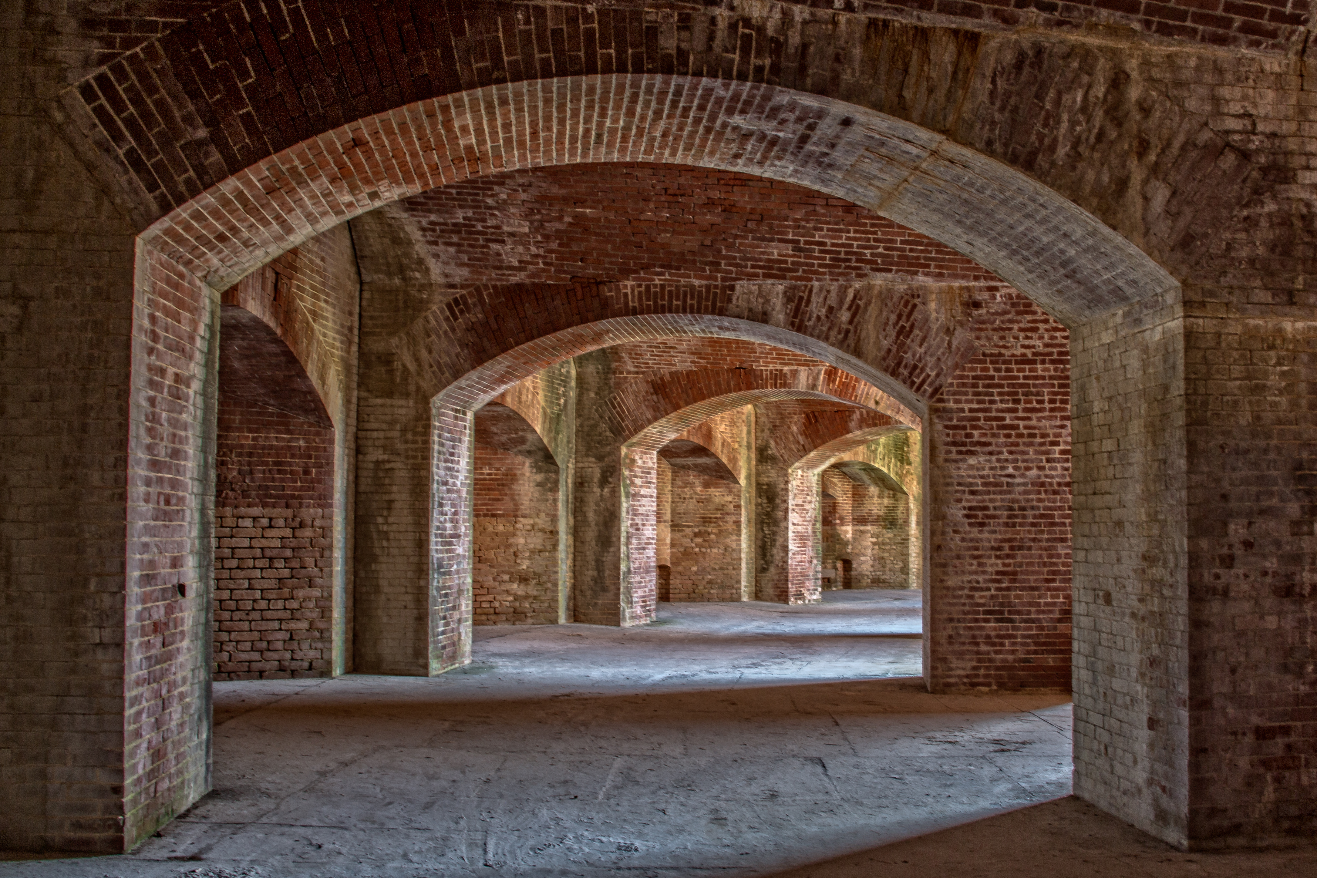
Look closely at the curved brick walls of Fort Massachusetts and you can read the Civil War in their color. The lowest courses are warm Louisiana red, laid by civilian crews before Mississippi seceded in January 1861. Above them, a band of cooler New England gray - bricks shipped thousands of miles down the Atlantic coast and around Florida's peninsula because the Union could no longer buy from Southern suppliers. And at the top, Louisiana red again, from after the war ended. Three distinct layers of brick, three chapters of American history, still visible on a wind-scoured barrier island twelve miles off the Mississippi coast.
A Fort That Never Fired in Anger
Ship Island's deep-water harbor made it strategically vital long before anyone laid a brick. It was the only natural harbor between Mobile Bay and the Mississippi River, sitting astride the shipping lanes that fed New Orleans. The War Department declared it a military reservation in 1847, and Congress authorized a fort in 1856. Construction began in June 1859 under the Army Corps of Engineers, with crews of up to 100 carpenters, stonemasons, blacksmiths, and stonecutters raising the walls. By early 1861, those walls stood six to eight feet above the sand. Then Mississippi seceded. An armed militia seized the unfinished fort, abandoned it, returned with Confederate troops who mounted cannons, and on July 9, 1861, exchanged twenty minutes of cannon fire with the Union Navy. That brief skirmish was the only direct military engagement the fort would ever see.
Staging Ground for New Orleans
After the Confederates abandoned Ship Island in September 1861, Union forces moved in and transformed the island into a massive military staging area. At its peak, 18,000 Union troops were stationed here, preparing for the campaign that would capture New Orleans in the spring of 1862. The island's harsh conditions - relentless sun, salt air, storms, and disease - proved deadlier than combat. More than 230 Union soldiers died and were buried on Ship Island during the war, their remains later moved to Chalmette National Cemetery near New Orleans. Nearly 40 buildings went up: a hospital, barracks, mess hall, bakery. The 2nd Louisiana Native Guard, one of the first African American regiments in the United States Army, was stationed here for almost three years. The fort itself was probably named for the USS Massachusetts, though it was never officially christened - in Army records, it remained simply the 'Fort on Ship Island.'
Pop Stone's Vigil
The Army Corps of Engineers worked on the fort until the fall of 1866, then handed it over to a civilian caretaker named C.H. 'Pop' Stone, whose job was to keep the place ready for a war that never came again. Eventually an ordnance sergeant took over, caring for the mounted cannons until 1903, when the last sergeant was relieved of duty and the Ship Island lighthouse keeper added the fort to his responsibilities. For decades the fort sat quietly, salt air eating at the mortar, waves lapping closer as the barrier island shifted beneath it. The northeast bastion eroded badly. Unlike the Cape Hatteras Lighthouse, which could be picked up and moved inland, Fort Massachusetts - tons of brick and concrete shaped into a massive arc - was going nowhere.
Sand as Shield
A 'Save the Fort' movement launched by Mississippians in the 1960s helped establish the Gulf Islands National Seashore, bringing federal protection. But protection from the sea requires more than a designation. The National Park Service devised an ingenious solution: piggybacking on Army Corps of Engineers dredging projects. When the Corps removes sand from ship channels, they pump it toward the fort, building a sandy beach that absorbs wave energy before it reaches the walls. In December 2001, a Historic Preservation Training Center crew arrived to repoint, replace, and reset the brickwork - the first hands to maintain the masonry since 1866, a gap of 135 years. Today Fort Massachusetts stands within the Gulf Islands National Seashore, accessible only by boat, its three-toned walls still holding against the Gulf.
From the Air
Located at 30.21°N, 88.97°W on the north shore of West Ship Island, roughly 12 miles south of Gulfport, Mississippi. The fort is a distinctive curved masonry structure visible on the western end of the island. Ship Island appears as a narrow white sand barrier island running east-west in the Gulf of Mexico. Gulfport-Biloxi International Airport (KGPT) is 12nm north; Keesler Air Force Base (KBIX) in Biloxi is 15nm northeast. Approach from the north over Mississippi Sound for the best view of the fort against the Gulf backdrop. The island chain - Cat Island to the west, Horn Island and Petit Bois to the east - provides excellent visual references at low altitude.