Fort Mills
Most coastal forts of the early 1900s had small underground facilities, maybe a magazine or two. Fort Mills had thirteen miles of electric railway, an underground hospital, a tunnel complex large enough to shelter an entire government, and enough firepower to command the entrance to Manila Bay from every angle. Named for Brigadier General Samuel Meyers Mills Jr., Chief of Artillery from 1905 to 1906, the fort covered nearly all of Corregidor Island and represented the most ambitious seacoast defense the United States ever built outside its own borders.
The Taft Board's Grand Design
The United States acquired the Philippines after the Spanish-American War in 1898 and quickly recognized Manila Bay's strategic vulnerability. The Taft Board of 1905 recommended a ring of modern fortifications at the bay entrance. The islands there had already been declared military reservations on April 11, 1902, and construction began almost immediately. By 1915, the Coast Defenses of Manila and Subic Bays were substantially complete: Fort Mills on Corregidor, Fort Hughes on Caballo Island, Fort Drum on El Fraile Island, and Fort Frank on Carabao Island. Only Fort Wint, on Grande Island in Subic Bay, sat outside the bay mouth. Corregidor, as the largest island, received the heaviest concentration of batteries, along with barracks, garrison buildings, and infrastructure for controlling two underwater minefields. The fort's disappearing guns could rise above their parapets to fire, then drop back behind concrete walls to reload, a mechanism designed for an era when naval warfare still meant ships trading broadsides with shore batteries.
A Tunnel Built on Borrowed Time
The Malinta Tunnel complex, Fort Mills' most remarkable feature, was constructed between 1932 and 1934, with work continuing until the Japanese invasion in December 1941. The Washington Naval Treaty prohibited new fortifications in the Pacific, so the Army found creative ways to build it without appropriated funds. Filipino convict labor handled unskilled tasks, and explosives slated for disposal were put to use blasting through Malinta Hill. The result was the largest tunnel complex in the entire American coastal defense system. The main east-west tunnel stretched roughly 1,400 feet, with lateral branches extending in both directions. During the siege, it sheltered General MacArthur's headquarters, President Quezon's wartime government, a thousand-bed hospital, and hundreds of civilians. The tunnel proved that some of the most consequential military engineering happens not in open daylight but underground, where improvisation matters more than budget lines.
The Guns Fall Silent
After Bataan fell on April 9, 1942, Japanese artillery turned exclusively on Corregidor. The bombardment was relentless: nine 240mm howitzers, thirty-four 149mm howitzers, and thirty-two additional artillery pieces joined 614 air missions that dropped 365 tons of bombs. On May 4 alone, more than 16,000 shells struck the island. Fort Mills' great guns, designed to fight ships, had no overhead protection against plunging fire. One by one, the batteries fell silent. Battery Geary was destroyed when a 240mm shell penetrated a magazine, detonating a blast so powerful it launched a 13-ton mortar 150 yards through the air and embedded another entirely inside a neighboring magazine. Battery Way's four 12-inch mortars, which had been out of service for years and were only partially restored in late April, were down to one operational weapon by May 5. Only Fort Drum's turrets, built inside a concrete battleship shape on El Fraile Island, proved impervious to the bombardment and kept firing until the surrender on May 6.
Assault from Above and Below
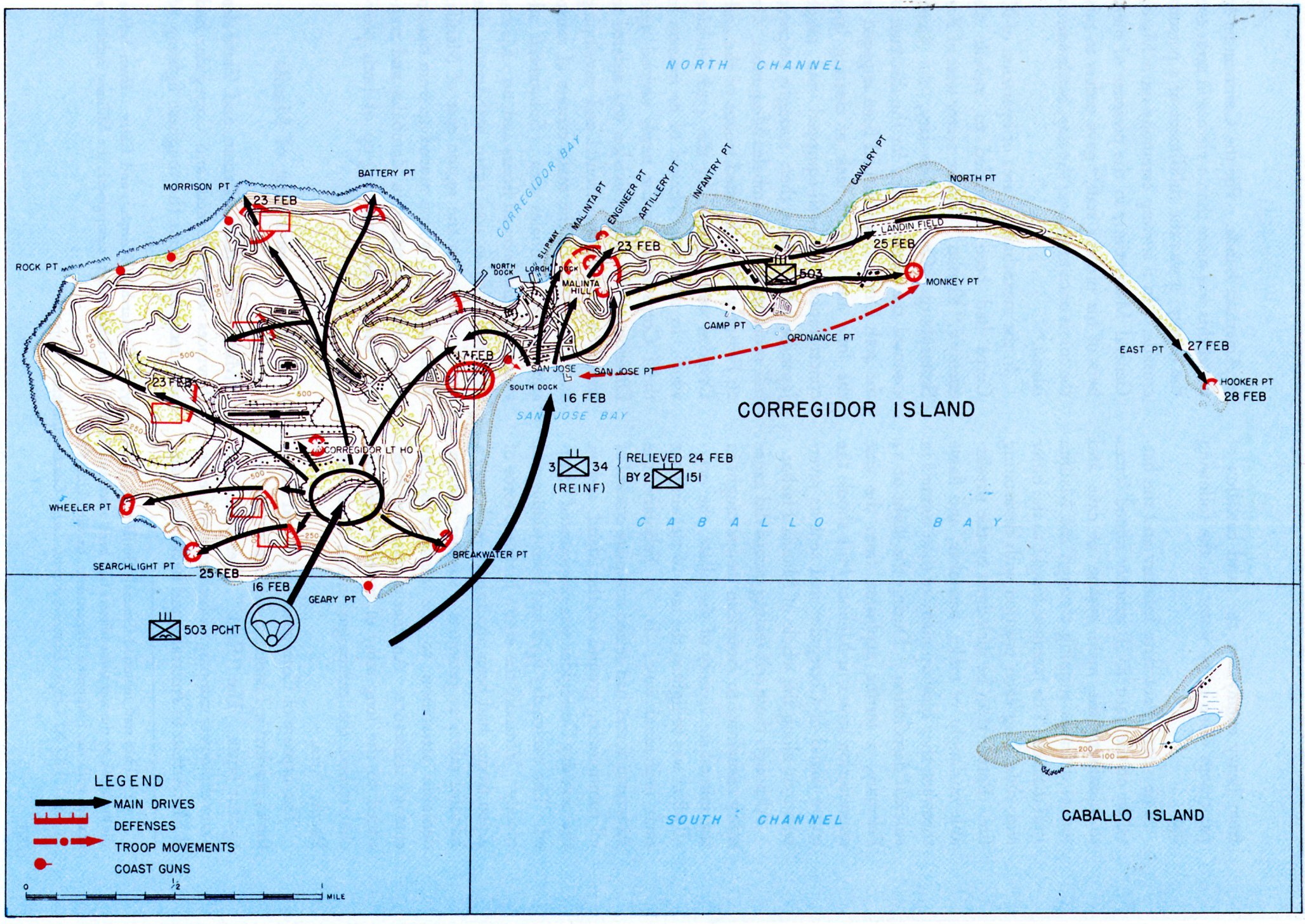
When American forces returned in February 1945, Corregidor was the final obstacle to reopening Manila Bay. Intelligence estimated 850 Japanese defenders. There were actually about 5,000, primarily naval forces under Captain Akira Itagaki. The plan called for a near-simultaneous airborne and amphibious assault, a combination rarely attempted on such difficult terrain. On February 16, the 503rd Parachute Regimental Combat Team jumped onto Topside, aiming for two drop zones barely adequate for the purpose: a former parade ground and a golf course. Each C-47 made two or three passes over the tiny targets. Stronger winds than forecast scattered paratroopers across the ruined landscape, producing a 25 percent injury rate. One stick of jumpers landed directly on the Japanese commander's observation post and killed him. The amphibious force, the 3rd Battalion of the 34th Infantry, hit the south shore two hours later. The Japanese fought with fierce determination, and the battle lasted ten days, but the high ground belonged to the Americans from the first morning.
Concrete and Memory
Fort Mills never returned to active service. Its shattered batteries, crumbling barracks, and tunnel mouths remain largely as the war left them, deliberate ruins maintained as a national shrine. The disappearing gun carriages that once rose and fell with mechanical precision now sit frozen in their last positions. Vegetation has reclaimed the electric railway tracks. The Malinta Tunnel, where a government sheltered and a general made his reluctant departure, hosts an audio-visual memorial. What makes Fort Mills remarkable is not just its scale, though thirteen miles of railway on a six-kilometer island is extraordinary, but the gap between its design and its fate. The Taft Board built it to repel battleships. It was destroyed by artillery firing from the hills of Bataan, barely twelve miles away. The fort's great guns pointed seaward, but the threat came from the land behind them.
From the Air
Located at 14.383N, 120.567E, Fort Mills occupied most of Corregidor Island at the entrance to Manila Bay. The island is tadpole-shaped, approximately 6 km long. Topside (western end) held the major batteries and is the highest ground. Look for Battery Way and Battery Geary positions on the southern coast. The Malinta Tunnel entrance is visible at the narrow Bottomside area. Kindley Field airstrip runs along the Tail End to the east. Surrounding fortified islands: Caballo (Fort Hughes) to the south, El Fraile (Fort Drum, shaped like a concrete battleship) further south, Carabao (Fort Frank) to the southeast. Nearest major airport: Ninoy Aquino International (RPLL/MNL), 48 km east.