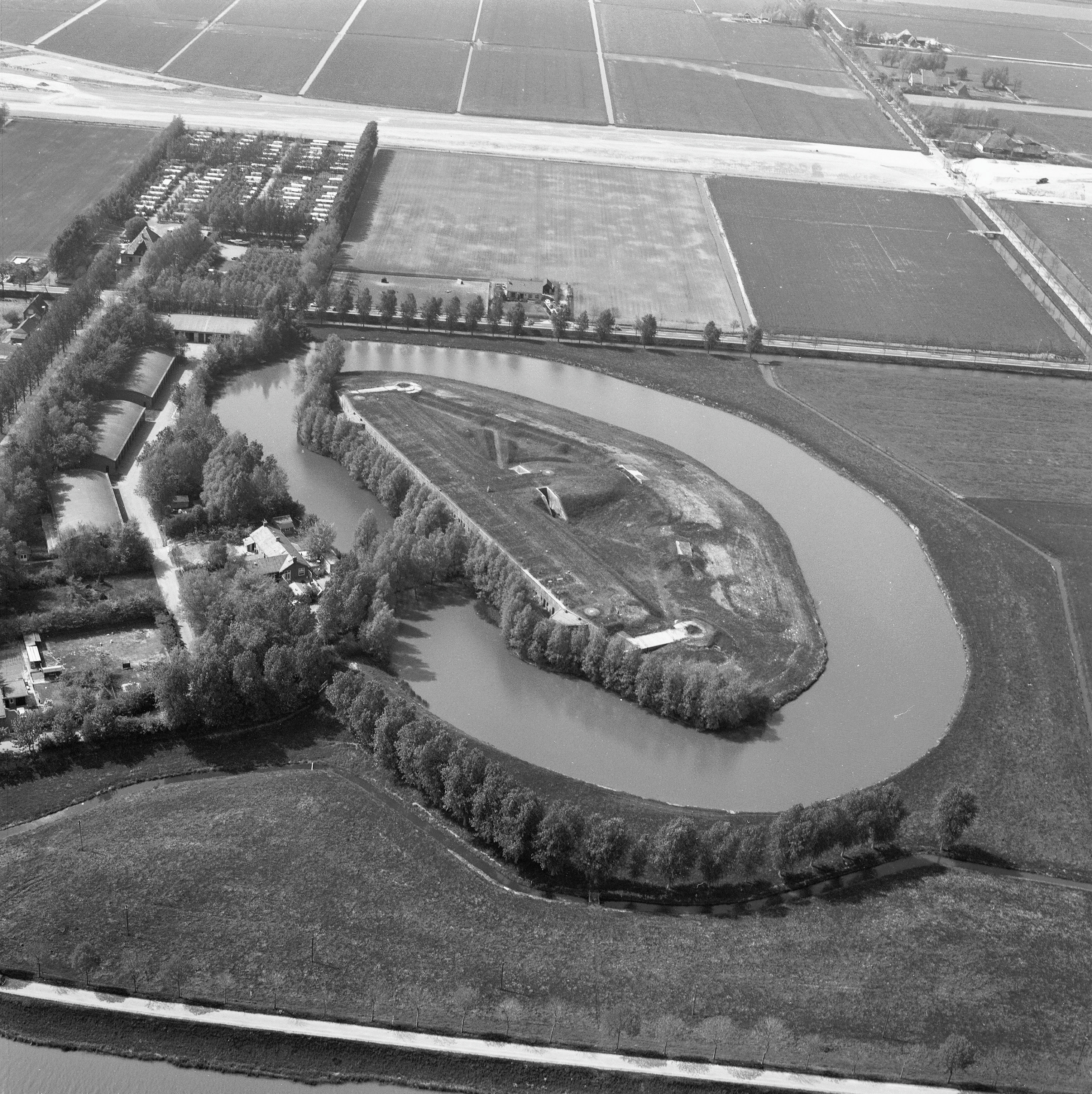
Fort North of Purmerend
The thick concrete that was poured to absorb artillery shells turned out, a century later, to be excellent for holding Bordeaux. Fort benoorden Purmerend was finished in 1912 to defend a corner of the Defence Line of Amsterdam. It never fired its guns in anger. By the 1980s a Dutch wine importer had moved in, drawn by the constant 12-degree temperature behind walls more than a meter thick. The army wanted bomb-proof. The wine merchants wanted bottle-proof. Same chambers, same answer. The fort still sits in the perfectly geometric Beemster polder, a UNESCO World Heritage Site twice over, now smelling more of oak and cork than of gunpowder.
The Geometry of the Beemster
The land around the fort is itself a heritage site. The Beemster was a lake until 1612, when a consortium of Amsterdam merchants drained it with windmills as an investment, creating a roughly forty-square-kilometer rectangle of new land below sea level. The reclamation engineers laid the polder out in a perfect Renaissance grid, the roads, canals and field boundaries set on cardinal axes, a piece of mathematical idealism rendered in soil. UNESCO inscribed the Beemster on the World Heritage List in 1999 as Droogmakerij de Beemster, the Beemster Polder, citing it as the first lake reclamation of its kind to retain its original geometric pattern. Fort benoorden Purmerend sits inside this grid. It is one of the few sites in the world listed twice on UNESCO's roster, once for the fort and once for the polder it stands in.
A Fort with a Specific Worry
Like every fort of the Stelling van Amsterdam, this one had a particular job: to defend the places that could not be drowned. The defenders' plan, laid out between 1881 and 1914, was to flood the countryside around Amsterdam with a sheet of shallow water, deep enough to stop wagons and infantry, too shallow for boats. But certain features stayed dry. The Beemster ring dike, raised above the surrounding land to keep the polder from refilling, would have stood out of the water. So would the Purmerenderweg and the Rijperweg, two elevated roads that crossed the line. An attacking army could march along these dry corridors. Fort benoorden Purmerend was placed exactly where it could sweep those roads and the ring dike with fire, plugging the gaps in the inundation. Its earth walls were finished in 1885; the concrete buildings inside followed between 1909 and 1912.
Built Late, Obsolete Sooner
The later forts of the Stelling, including this one, were built to handle artillery that had grown alarmingly powerful in the decades leading up to 1900. Reinforced concrete and earth cover were piled on to defeat the explosive shells that gun designers were producing. By the time the fort was complete in 1912, those shells had already outpaced the designers. Two years later, the First World War demonstrated what high-explosive bombardment did to even the heaviest forts; Belgium's modern fortresses at Liege and Antwerp were shattered within days. The Stelling never had to find out the hard way. The Netherlands held its neutrality through the war and the forts kept guard over a frontier no army crossed. When German forces did invade in May 1940, they came too fast and from too many directions for a static water defense to slow them, and the line never carried out its design.
From Magazine to Cellar
After 1945 the Dutch Army kept the forts on standby for a while, then began letting them go. Fort benoorden Purmerend was sold in 1982 to a wine merchant who had already been quietly using it since the late 1970s. The reasoning was simple. Wine wants a steady cool temperature, no light, no vibration, and high humidity. Bomb-proof concrete with two-meter walls under an earth blanket delivers all four without needing any climate control at all. The wine importer J. Bart now operates from the fort, storing pallets of European wine where ammunition once sat in racks. The conversion has preserved the fort better than most of its sister sites, which fell into disrepair before the heritage movement caught up with them.
What You Can Still See
Visitors can walk parts of the fort grounds and, by appointment, see inside the cellars. The earth banks are mowed for hay and dotted with wildflowers; the moat reflects poplar trees and a sky that, in this corner of the Netherlands, often runs to the kind of high cloudscape Dutch painters made famous. The polder is laid out so cleanly that the surrounding farms still echo the seventeenth-century plan: long rectangles of pasture, dead-straight ditches, the occasional white farmhouse marking a corner. From the dike road, the fort is barely visible, just a low green rise. The plan worked, in a way the planners never expected. Camouflage by landscape architecture has kept the fort whole, and the wine, by all accounts, ages beautifully.
From the Air
Located at 52.54N, 4.96E, in the southeast corner of the Beemster polder roughly 3 km north of Purmerend. The fort sits at the intersection of the Purmerenderweg and the Beemster ring dike. From 1,500-3,000 feet AGL the Beemster's perfect rectangular grid is one of the most striking polder patterns in the Netherlands. Schiphol (EHAM) is about 25 km southwest; Hilversum (EHHV) about 32 km southeast; Lelystad (EHLE) about 30 km east across the IJsselmeer. Amsterdam's city skyline is visible to the south in clear weather.