Fort of Bost
Pull a 100 afghani note from your pocket in Afghanistan and you will see it: a soaring arch framed against an empty sky, its brickwork still sharp after a thousand years. The Qala-e-Bost arch is the most recognizable architectural image in the country, a national symbol printed on currency and postage stamps alike. But stand at its base, six miles south of Lashkargah where the Helmand and Arghandab rivers converge, and the reality is more complicated than the banknote suggests. The arch is beautiful. It is also nearly all that remains of a fortress and settlement that once sprawled across 10 kilometers of river-fed terrain -- a site that some believe dates back 3,000 years, to an era before Alexander the Great marched through this same landscape.
Where Two Rivers Meet
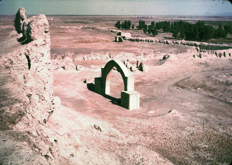
The Fort of Bost occupies a position that explains its long history. Situated near the confluence of the Helmand and Arghandab rivers in Helmand Province, the site commanded one of the few reliable water sources in a landscape that is otherwise unyielding desert. The rivers made agriculture possible here -- visitors throughout history have described the area as green with date palms and fruit trees, an oasis quality that contrasts sharply with the arid terrain visible in every direction. That combination of water, arable land, and a defensible position made Bost a natural gathering point for civilizations stretching back millennia. The archaeological site is vast, covering roughly 10 kilometers, though much of it has never been systematically excavated.
The Arch That Outlasted Everything
Of all that Bost once contained, the arch is what survives. Standing 25 meters tall, it is a four-centered pointed arch dating from the 11th century, part of the iwan -- the vaulted entrance hall -- of what was once a grand mosque or religious building. Its construction is a masterwork of medieval Islamic craftsmanship: baked carved bricks arranged in intricate geometric patterns, with stucco insets and calligraphic inscriptions woven into the design. The brickwork is not merely structural but ornamental, each brick shaped and placed to create repeating geometric patterns that catch light and shadow differently as the sun moves. Around the arch, the ruins of an imposing fortress wall and the mud-brick foundations of private houses from the Islamic period are still traceable -- the bones of a community that flourished under successive empires.
From Michener's Pages to Modern Ruin
American readers encountered Bost through James A. Michener's 1963 novel Caravans, which used the fortress -- referred to as Qala Bist -- as a backdrop for its story of an American diplomat searching for a missing woman in Afghanistan. Michener's novel romanticized the landscape, but the reality of Bost's modern history has been harsher. In 2006, construction began on a cobblestone road connecting Lashkargah to the arch, an attempt to make the site more accessible to visitors. By 2008, adventurous travelers could descend into an ancient shaft at the site -- 20 feet across and 200 feet deep -- equipped with a spiral staircase and dark side chambers whose original purpose remains unknown. Restoration work began in 2020, an effort to preserve what decades of conflict and neglect had eroded.
Shelter Among the Ruins
In 2021, as Taliban forces fought for control of Lashkargah in the battle that would ultimately topple the provincial government, hundreds of displaced families fled to the ruins of Bost. The ancient fortress became an emergency shelter, its crumbling walls offering the only cover available to people caught between advancing fighters and American airstrikes. It was a bitter irony: a site that had endured three millennia of conquest and empire was now sheltering the latest generation of Afghans displaced by war. Thousands of people still visit the fort during holidays like Eid, walking the same ground where refugees once huddled. The arch rises above them all -- above the tourists and the displaced, above the archaeologists and the soldiers -- indifferent to the centuries, its geometric brickwork still casting the same shadows it cast when the Ghaznavids ruled from the palaces next door.
From the Air
Located at 31.50N, 64.36E, approximately 6 miles south of Lashkargah at the confluence of the Helmand and Arghandab rivers. The monumental arch is the most visible feature from the air, rising 25 meters above the surrounding ruins. The archaeological site extends over approximately 10 km. Nearest significant airfield is Camp Shorabak/Bastion (OAZI), roughly 20 km to the southwest. Best viewed from 2,000-4,000 feet AGL where the arch, river confluence, and the contrast between irrigated land and desert are all visible. The green corridor of the Helmand River valley provides a clear visual reference.