Fort of Santa Catalina, Lima
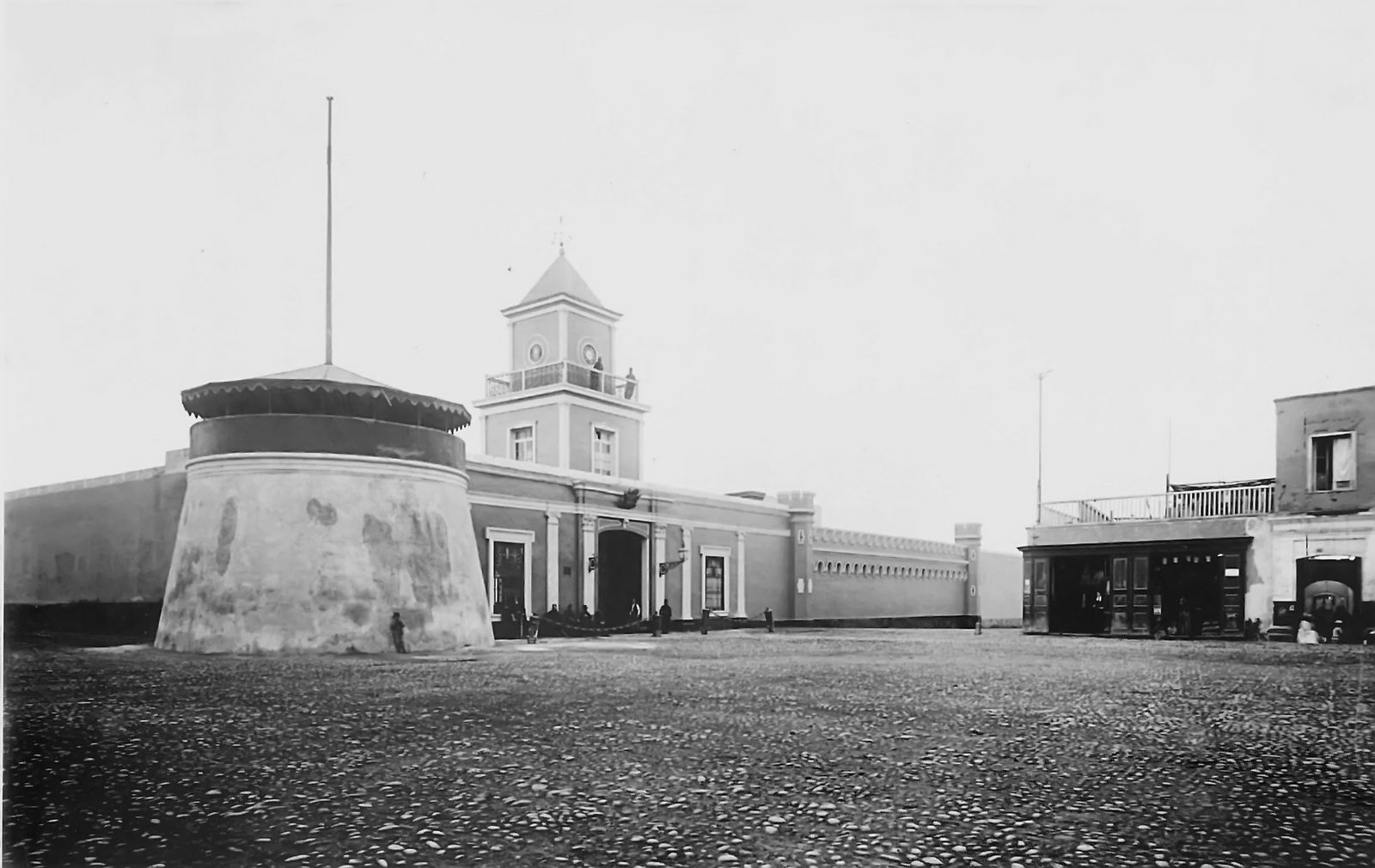
Old cannons jut from the ground on either side of the entrance, repurposed as bollards -- or what Lima's colonial builders called "gutters" -- guarding a massive wooden doorway framed by neoclassical pilasters. The Fort of Santa Catalina is easy to overlook in the dense urban fabric of Barrios Altos, one of Lima's oldest neighborhoods. But behind its adobe corner tower and merlon walls lies one of the few remaining examples of Spanish colonial military architecture in Peru, a barracks that witnessed the last decades of viceregal rule and the violent birth of a republic.
Orchards to Armory
The land where the fort stands was once agricultural, known as the "Huerta de los Llanos" and "Huerta Perdida," belonging to the Monasteries of Santa Catalina de Siena and de la Concepcion. In 1698, the Monastery of la Concepcion granted the land in emphyteusis -- a long-term lease -- that passed through several hands over the following century. The property eventually reached Colonel Joaquin de la Pezuela, General Commander of Spanish Artillery, who converted it into a purpose-built barracks for the artillery corps. According to the Liman traditionalist Ricardo Palma, construction began during the government of Viceroy Gabriel de Aviles, who served from 1801 to 1806. Pezuela, who oversaw the project, would later become Viceroy of Peru himself, only to be deposed in a coup by his own officers in 1821 as the independence wars closed in.
Stone, Adobe, and Arrowslits
The fort's facade blends defensive pragmatism with neoclassical ambition. A corner tower made of adobe rises at a slope, designed to deflect projectiles. The main entrance features a large wooden door flanked by pilasters with Corinthian and Ionic capitals, capped by a reduced arch. Flanking towers with merlons -- the tooth-like battlements that crown fortress walls -- are pierced with arrowslits, a medieval defensive feature adapted for colonial use. A square wooden tower once held a clock, now gone. Inside, a cobblestone entryway paved with pebbles leads to the main courtyard, the plaza de armas, where an original flagpole still stands beside an artillery cannon. The architect Hector Velarde, one of Lima's most notable scholars of colonial architecture, noted the building's distinctive character as a rare fusion of military function and architectural elegance in a city better known for its churches and palaces.
From Viceroys to Independence
The fort served as an active military installation through the turbulent final years of Spanish colonial rule. Artillery units stationed here would have been among the forces defending Lima against the independence movements that swept South America in the 1810s and 1820s. Pezuela's connection to the barracks adds a layer of historical irony: as viceroy, he tried to negotiate with the liberating forces of Jose de San Martin, only to be overthrown by hardline royalist officers who considered him too conciliatory. The barracks continued in military use after independence, passing through Peru's various republican governments. The original complex was considerably larger than what survives today -- approximately five times its current footprint, covering a total area that records list at 25,250 square meters.
Restoration and Renewal
Only about one-fifth of the original fort remains standing, but what survives is in remarkably good condition. The frontispiece, outer walls, and the Chapel of Saint Barbara have weathered two centuries of Lima's earthquakes and urban development. The National Institute of Culture took ownership of the building, and archaeological excavations helped document its original layout. Today the fort houses the Escuela Taller de Lima, a restoration school subsidized by the Spanish Association of International Cooperation, where students learn the craft of preserving colonial buildings by working on the very structure that shelters them. It is an elegant solution: a Spanish-built barracks, constructed to project imperial power in the colonies, now sustained by Spanish development funds dedicated to preserving the heritage of the country that broke free from that empire.
From the Air
The Fort of Santa Catalina sits at 12.056°S, 77.027°W in Lima's Barrios Altos neighborhood, east of the historic center. From 3,000-5,000 feet AGL, the fort is within the dense urban grid of central Lima but difficult to distinguish from surrounding buildings. The Rimac River runs to the north, and the colonial center with the Plaza Mayor is approximately half a mile to the west. Jorge Chavez International Airport (SPJC/LIM) is about 7 miles northwest. Lima's characteristic garua fog often limits visibility below 1,000 feet between June and November.