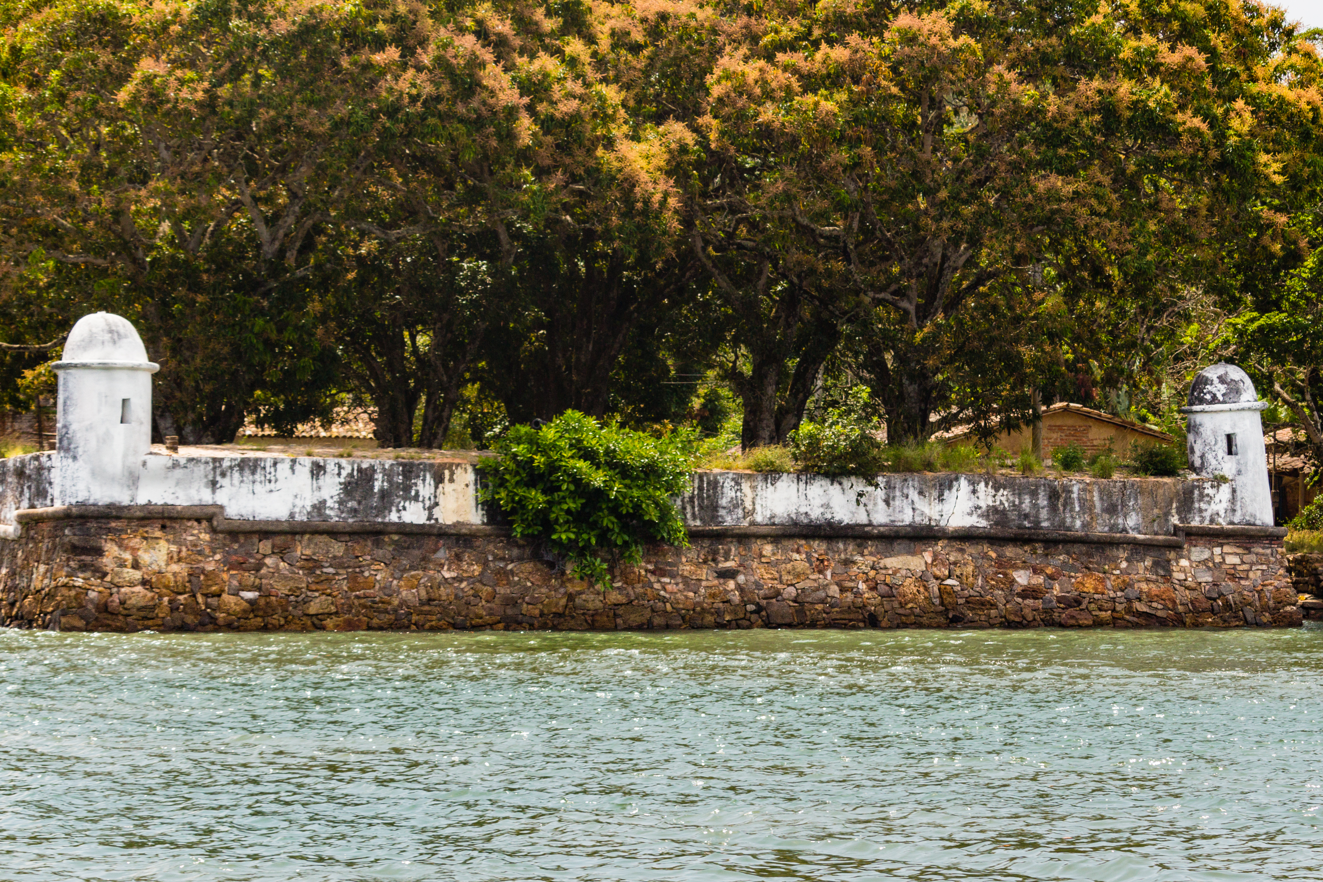
Fort Santa Cruz do Paraguaçu
By 1659 there were three forts guarding the mouth of the Paraguacu River, and the most important of them faced the water on a low point of land near what is now Maragojipe. Its job was straightforward: if you wanted to reach the sugar mills of Iguape, the towns of Maragogipe and Cachoeira, or the whole wealthy hinterland behind Salvador, you had to sail past Fort Santa Cruz and its sister fort across the river. For about a century and a half the crossfire worked. Then the fort stopped mattering - and in the way of coastal forts that stop mattering, it was forgotten slowly and completely. What stands now is a stone courtyard, a domed sentry turret, and a single cannon.
Stone on a Strategic Bend
The current shape of the fort - a six-sided plan with three sides flanking the water - probably dates to the early eighteenth century, built over an older structure from the first half of the seventeenth. Scholars cannot agree on who raised the first version. What is clear is the logic of the location. The Paraguacu River is the main artery of the Reconcavo Baiano, the arc of sugar country wrapping the inland shore of All Saints Bay. Whoever controlled the river mouth controlled the commerce of the entire inland. Across the water sat the Fort of Forca, and the two forts could crossfire any vessel moving upriver. Brick sentry boxes stood at the corners of the Santa Cruz. The walls were built of stone, the best available technology for stopping shot from approaching ships.
The Dutch Invasion
The fort's biggest moment came during the Dutch-Portuguese war. The Dutch West India Company, seeking to pry Brazil from Portuguese Iberian control during the Iberian Union, captured Salvador briefly in 1624 and 1625 and held Pernambuco from 1630 to 1654. From the Santa Cruz, Portuguese gunners watched the Dutch try to push up the Paraguacu to reach the sugar mills. They did not get through. The fort's crossfire with the Fort of Forca protected the entire inland productive zone - the engenhos, the towns, and with them the wealth that bankrolled Portuguese resistance. Every barrel of sugar that left the Reconcavo during those years passed, in effect, under the guns of this fort.
Slow Decline and an Unfinished Restoration
By 1759 the fort's military condition was poor. An engineer named Jose Antonio Caldas inspected it and reported seven dismounted artillery pieces and barracks in ruin. A small single-storey building above the courtyard still held the command house, the troop quarters, and the mess. A captain commanded the garrison. In 1762 the government of Bahia restored the barracks - probably under the direction of Joao Abreu de Carvalho Contreiras - after Caldas returned for another inspection. The Peninsular War, which brought the Portuguese royal family fleeing to Brazil in 1808, prompted a brief round of maintenance. But by 1816 the fort was declared militarily useless and decommissioned. One final moment of glory came during the Brazilian wars of independence (1822-1823): local fighters from Cachoeira - the cachoeiranos - captured a Portuguese ship, and the abandoned fort, already nicknamed a fortim (a little fort), prevented the Portuguese from taking it back. Emperor Pedro II's court chronicler Epiphanio Pessoa recorded that the squadron passed the fortlet on the morning of 10 November 1859 and noted that small stronghold's small but telling victory.
What Remains
The federal heritage service claimed the ruins for the Union in 1938. A restoration plan was drawn up in 1959. It was never implemented. Today a visitor reaches the fort by dirt track and finds a courtyard of stone walls, a single surviving sentry turret with its circular dome, and one cannon left over from a garrison long since departed. Tidal water comes up around the low point. Gulls work the mud. The Paraguacu still carries boats upstream toward the towns the fort was built to protect, and the old fortresses across the water are also ruins now. It is one of those places where silence has a shape - a reminder that most of history's strategic geography turns, eventually, into gentle countryside, and that someone once thought this little point of land was worth dying on.
From the Air
Located at 12.80 degrees south, 38.86 degrees west on the right (east) bank of the mouth of the Paraguaçu River, near Maragojipe, Bahia. Elevation near sea level. The fort sits within the Recôncavo Baiano at the inland end of All Saints Bay (Baía de Todos os Santos). Low-level aerial views reveal the river's broad, serpentine mouth and the agricultural patchwork of the sugar hinterland. Nearest airports: Salvador (SBSV/SSA) about 60 km northeast (direct line across the bay), and Feira de Santana (SBQM) about 75 km north. Generally clear coastal weather; afternoon sea-breeze showers common in summer.