Fort Sherman
Soldiers who trained at Fort Sherman called it "The Green Hell." The nickname was earned. Half of the installation's 23,100 acres consisted of unbroken tropical jungle on Toro Point, where the Caribbean meets the western bank of the Panama Canal. From 1951 to 1999, roughly 9,000 troops per year slogged through this terrain as students of the Jungle Operations Training Center, learning to fight, survive, and navigate in one of the most punishing environments on Earth. But the fort's story began decades earlier and involved something far heavier than backpacks and machetes: disappearing gun carriages, coastal defense mortars, and the first operationally deployed early warning radar in the United States military.
Steel at the Water's Edge
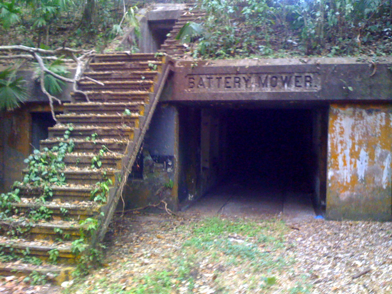
Construction of Fort Sherman began in January 1912, part of the original 1910 defensive plans developed concurrently with the Panama Canal itself. Named by War Department General Order No. 153 in honor of General William Tecumseh Sherman, the fort served as the primary Caribbean-side infantry base, while Fort Amador protected the Pacific entrance. The defensive arsenal was formidable. Battery Baird and Battery Howard each mounted four 12-inch Model 1896 mortars capable of lobbing shells in high arcs onto the decks of approaching warships. Batteries Stanley and Mower carried 14-inch guns on disappearing carriages -- mechanisms that raised the gun to fire, then lowered it behind the parapet wall to reload, making it nearly invisible to ships at sea. Batteries Kilpatrick, Sedgwick Pratt, and Alexander Mackenzie added 6-inch and 12-inch guns. During World War I, supplemental batteries with 155mm and 75mm field pieces reinforced the position.
Radar Before Pearl Harbor
In 1941, Fort Sherman became the site of the U.S. military's first operationally deployed early warning radar when an SCR-270 system was installed on the base. This was the same type of radar that would famously detect the approaching Japanese aircraft at Pearl Harbor on December 7 of that year -- though the warning was tragically disregarded. At Fort Sherman, the SCR-270 scanned the Caribbean approaches to the canal, part of a broader effort to protect what was then among the most strategically vital waterways on the planet. The developed areas of the fort included housing, barracks for 300, a small airstrip, and recreational facilities, but the radar installation underscored the base's primary purpose: keeping enemy forces from ever reaching the canal locks.
Jungle School
After the Coast Artillery Corps was decommissioned, Fort Sherman's dense jungle found a new military purpose. The United States Army South established the Jungle Operations Training Center in 1951 to train both American and allied Central American forces in tropical warfare. The curriculum was grueling: students learned to move, fight, and survive in triple-canopy forest with limited supplies and hostile terrain. A ten-day Air Crew Survival Course prepared downed pilots for jungle bailouts, while the four-week Engineer Jungle Warfare Course taught combat engineering in tropical conditions. Graduates earned the Jungle Expert Patch. During the Vietnam War, the JOTC became an essential pipeline for troops headed to Southeast Asia, where the skills learned in Panama's Caribbean lowlands proved directly applicable. Between 1966 and 1979, the site also served a more exotic purpose: 1,160 sounding rockets were launched from the base, reaching altitudes of up to 99 kilometers.
Hollywood and Handover
Fort Sherman had one last unexpected role before its closure. The base's atmospheric jungle ruins and decaying colonial-era fortifications caught the eye of filmmakers, and in 2008, scenes for the James Bond film Quantum of Solace were shot on location here. The fort officially closed in 1999 under the terms of the canal treaties, and the JOTC relocated to Hawaii. Panama took over the base and designated it Base Aeronaval Cristobal Colon, operating it as a naval station and jungle warfare school. In January 2026, the U.S. Army Security Cooperation Group-South took command of a new Combined Jungle Operations Training Center at the site, reviving the partnership that had defined Fort Sherman for half a century. The new course runs 18 days and covers fire-building, shelter construction, tracking, and patrol exercises. Soldiers who complete it earn the Jungle Warfare Tab -- a lineage that stretches back to The Green Hell.
From the Air
Fort Sherman sits at 9.363N, 79.953W on Toro Point at the Caribbean entrance to the Panama Canal, directly across the waterway from the city of Colon. From 3,000-5,000 feet AGL, the extensive cleared areas and remnants of coastal battery positions are visible along the shoreline, with dense jungle covering the interior. The Gatun Locks are visible to the southeast. France Field/Enrique Adolfo Jimenez Airport (MPEJ) near Colon is approximately 5 miles to the east. Tocumen International Airport (MPTO) in Panama City is the region's primary commercial airport. Expect tropical maritime conditions with frequent low clouds, rain showers, and afternoon thunderstorms.